# 24.10.14 Land Biomes

Part one: Land biomes

Hawaii biomes:

<span>[https://www.youtube.com/watch?v=ajpGScyuPiE](https://www.youtube.com/watch?v=ajpGScyuPiE)</span><span></span>

[Download mod12-land\_biomes.pdf (application/pdf, 6.2 MB)](https://bookstack.kamuela.org/attachments/233)

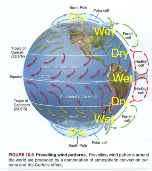
Look:Here's what we learned so far:
<figure id="bkmrk-cd6cd.png">![cd6cd.png](https://bookstack.kamuela.org/uploads/images/gallery/2026-09/KD2lZkausKgelmKl-cd6cd-ajbowhsk.png)<figcaption>cd6cd.png</figcaption></figure>  
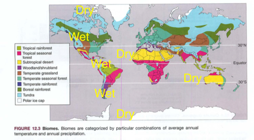
Now look at this map, and compare with your trusty globe:<div id="bkmrk-6a22f.pngsee-the-pat"><figure>![6a22f.png](https://bookstack.kamuela.org/uploads/images/gallery/2026-09/5a1ix7ts2Q1BfL2w-6a22f-bzbonkyh.png)<figcaption>6a22f.png</figcaption></figure>See the pattern? Pay close attention to cause and effect:

- onshore moist air from the Pacific ocean hits the mountains near Seattle=rainy there
- onshore moist air from the lower Atlantic ocean hits the amazon basin=rainy there
- dry air moving down from the Mediterranean moves over the Sahara Desert=dry there
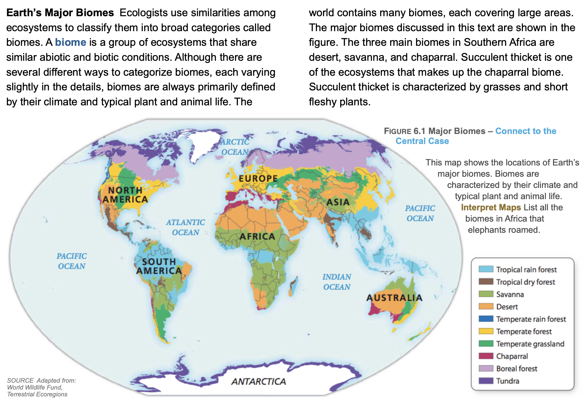
<div><figure>![Screenshot 2024-10-14 at 2.14.31 PM.png](https://bookstack.kamuela.org/uploads/images/gallery/2026-09/mYDfFPIM2XhCowiZ-screenshot-2024-10-14-at-2-14-31-pm-7gd9xbic.png)<figcaption>Screenshot 2024-10-14 at 2.14.31 PM.png</figcaption></figure></div><figure>![Screenshot 2024-10-14 at 2.14.43 PM.png](https://bookstack.kamuela.org/uploads/images/gallery/2026-09/NcmN3nJtrxkdmrTl-screenshot-2024-10-14-at-2-14-43-pm-442sosch.png)<figcaption>Screenshot 2024-10-14 at 2.14.43 PM.png</figcaption></figure><figure>![Screenshot 2024-10-14 at 2.14.54 PM.png](https://bookstack.kamuela.org/uploads/images/gallery/2026-09/gSVb9WIDpzyZNDem-screenshot-2024-10-14-at-2-14-54-pm-nhiqj7pd.png)<figcaption>Screenshot 2024-10-14 at 2.14.54 PM.png</figcaption></figure>There are about 9 Biomes, usually defined by <span style="font-weight: bold;">precipitation</span> (rain, fog, others) and <span style="font-weight: bold;">temperature</span>. </div><div id="bkmrk-the-big-island-has-8">

- The Big Island has 8 of the 9 biomes, or in the 12 biome model, we have 11/12, or 9 of 13, or 10 of 14 in another model.
- Many models...[https://www.hawaiimagazine.com/content/hawaii-has-10-worlds-14-climate-zones-explorers-guide-each-them](https://www.hawaiimagazine.com/content/hawaii-has-10-worlds-14-climate-zones-explorers-guide-each-them)
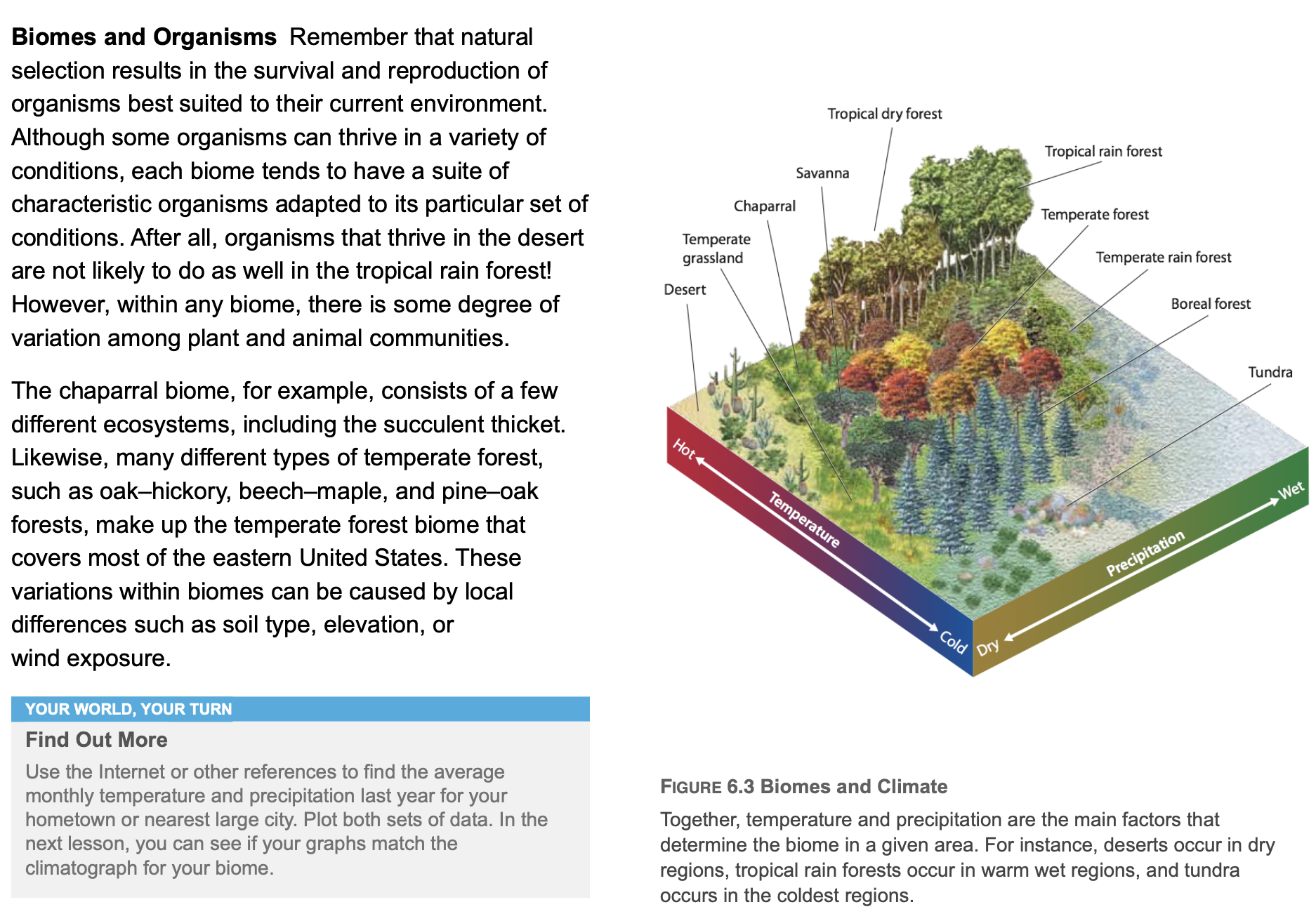
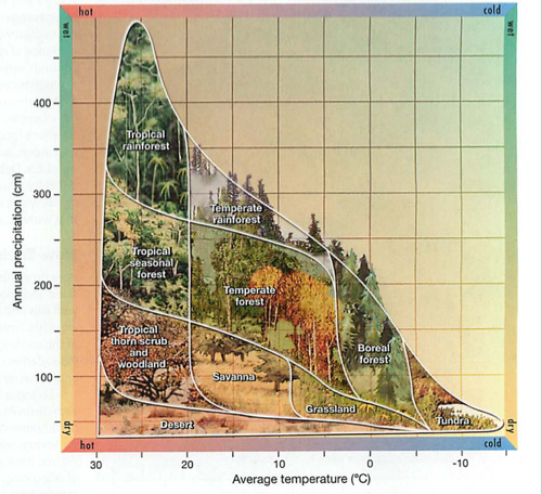
- Traveling up a mountain is like crossing biomes. Check this out:

</div><div id="bkmrk-302cd.png"><figure>![302cd.png](https://bookstack.kamuela.org/uploads/images/gallery/2026-09/I7xXTzlesjTRDJwV-302cd-iq0syn3i.png)<figcaption>302cd.png</figcaption></figure></div><div id="bkmrk--2">  
</div><div id="bkmrk-imagine-driving-from">

- Imagine driving from Hamakua or Hilo up to the summit of Mauna Kea: tropical rain forest to temperate (mild) rain forest to boreal (north) forest to tundra.
- There is even a glacier up on Mauna Kea. Cool.
- This would be like starting in the upper right corner of the diagram and moving diagonally down and to the left.

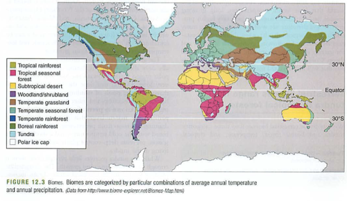
Now check out the planet again:</div><div id="bkmrk-703d0.pngnotice-the-"><figure>![703d0.png](https://bookstack.kamuela.org/uploads/images/gallery/2026-09/vqPfxKr1iVCLc9w0-703d0-eejzuteo.png)<figcaption>703d0.png</figcaption></figure>  
Notice the horizontal bands. If you've read "Guns Germs and Steel" you know that humans migrated horizontally, so their crops and livestock would thrive in similar biomes. See? Migrating north to south is tough.How is this changing?[https://climate.nasa.gov/interactives/climate-time-machine](https://climate.nasa.gov/interactives/climate-time-machine)</div><div id="bkmrk-%3D%3D%3D%3D%3D%3D%3D%3D%3D%3D%3D%3D%3D%3D%3D%3D%3D%3D%3D%3D">=======================</div><div id="bkmrk-climate-change-and-b"><span style="font-weight: bold;">Climate change and biomes</span></div><div id="bkmrk-find-your-home-here%3A"><span style="font-weight: bold;">Find your home here:</span></div><div id="bkmrk-https%3A%2F%2Fimpactlab.or">[https://impactlab.org/map/#usmeas=absolute&amp;usyear=1986-2005&amp;gyear=1986-2005](https://impactlab.org/map/#usmeas=absolute&amp;usyear=1986-2005&amp;gyear=1986-2005)</div><div id="bkmrk-then-zoom-ahead-to-w">Then zoom ahead to when you are 100 years old in 2008 or so...</div><div id="bkmrk-https%3A%2F%2Ffitzlab.shin">[https://fitzlab.shinyapps.io/cityapp/](https://fitzlab.shinyapps.io/cityapp/)</div><div id="bkmrk--3">  
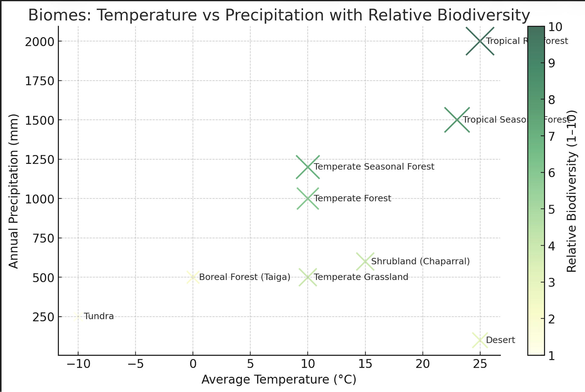
</div><div id="bkmrk-biomes-and-biodivers"><span style="font-weight: bold;">Biomes and biodiversity:</span></div><div id="bkmrk-biomes-provide-the-p"><span style="font-weight: bold;">Biomes provide the physical and climatic framework, while biodiversity fills that framework with living systems.</span> Warmer and wetter biomes usually support greater biodiversity, while harsher biomes restrict it.

<span style="font-weight: bold;">B</span><span style="font-weight: bold;">iodiversity</span> is complex (genes, species, ecosystems), ecologists usually talk in <span style="font-weight: bold;">relative terms</span>: how species richness compares across biomes. I’ll use the <span style="font-weight: bold;">classic global biodiversity gradient</span> (warm + wet = highest; cold + dry = lowest).

## <span style="font-weight: bold;">Relative Biodiversity by Biome</span>

<span style="font-weight: bold;">1 = very low diversity</span> and <span style="font-weight: bold;">10 = very high diversity</span>, based on species richness patterns.

<div class="table" id="bkmrk-biome-relative-biodi"><div id="bkmrk-biome-relative-biodi-1"><div id="bkmrk-biome-relative-biodi-2"><div><div class="container"><table class="__wikiTableVersion:Lion headingrow gridlines alternating" frame="box" rules="all" style="" width="1px"><tbody><tr><td class="cell" id="bkmrk-biome"><div><div><div><div><div><span style="font-weight: bold;">Biome</span>

</div></div></div></div></div></td><td class="cell" id="bkmrk-relative-biodiversit-1"><div><div><div><div><div><span style="font-weight: bold;">Relative Biodiversity (1–10)</span>

</div></div></div></div></div></td><td class="cell" id="bkmrk-rationale"><div><div><div><div><div><span style="font-weight: bold;">Rationale</span>

</div></div></div></div></div></td></tr><tr><td class="cell" id="bkmrk-tundra"><div><div><div><div><div><span style="font-weight: bold;">Tundra</span>

</div></div></div></div></div></td><td class="cell" id="bkmrk-1"><div><div><div><div><div>1

</div></div></div></div></div></td><td class="cell" id="bkmrk-harsh-climate-%28cold%2C"><div><div><div><div><div>Harsh climate (cold, dry, short growing season) → very few species.

</div></div></div></div></div></td></tr><tr><td class="cell" id="bkmrk-boreal-forest-%28taiga"><div><div><div><div><div><span style="font-weight: bold;">Boreal Forest (Taiga)</span>

</div></div></div></div></div></td><td class="cell" id="bkmrk-2"><div><div><div><div><div>2

</div></div></div></div></div></td><td class="cell" id="bkmrk-cold%2C-conifer-domina"><div><div><div><div><div>Cold, conifer-dominated, acidic soils → moderate productivity but low species richness.

</div></div></div></div></div></td></tr><tr><td class="cell" id="bkmrk-temperate-grassland"><div><div><div><div><div><span style="font-weight: bold;">Temperate Grassland</span>

</div></div></div></div></div></td><td class="cell" id="bkmrk-4"><div><div><div><div><div>4

</div></div></div></div></div></td><td class="cell" id="bkmrk-fewer-plant-species-"><div><div><div><div><div>Fewer plant species (mostly grasses), but supports large herbivore and predator diversity.

</div></div></div></div></div></td></tr><tr><td class="cell" id="bkmrk-shrubland-%28chaparral"><div><div><div><div><div><span style="font-weight: bold;">Shrubland (Chaparral)</span>

</div></div></div></div></div></td><td class="cell" id="bkmrk-4-1"><div><div><div><div><div>4

</div></div></div></div></div></td><td class="cell" id="bkmrk-moderate-climate%2C-se"><div><div><div><div><div>Moderate climate, seasonal drought → adapted plant/animal communities, but limited overall richness.

</div></div></div></div></div></td></tr><tr><td class="cell" id="bkmrk-desert"><div><div><div><div><div><span style="font-weight: bold;">Desert</span>

</div></div></div></div></div></td><td class="cell" id="bkmrk-3"><div><div><div><div><div>3

</div></div></div></div></div></td><td class="cell" id="bkmrk-very-low-precipitati"><div><div><div><div><div>Very low precipitation → low species count, though high specialization.

</div></div></div></div></div></td></tr><tr><td class="cell" id="bkmrk-temperate-forest"><div><div><div><div><div><span style="font-weight: bold;">Temperate Forest</span>

</div></div></div></div></div></td><td class="cell" id="bkmrk-6"><div><div><div><div><div>6

</div></div></div></div></div></td><td class="cell" id="bkmrk-mixed-tree-communiti"><div><div><div><div><div>Mixed tree communities, moderate climate → higher diversity than grasslands/taiga.

</div></div></div></div></div></td></tr><tr><td class="cell" id="bkmrk-temperate-seasonal-f"><div><div><div><div><div><span style="font-weight: bold;">Temperate Seasonal Forest</span>

</div></div></div></div></div></td><td class="cell" id="bkmrk-6%E2%80%937"><div><div><div><div><div>6–7

</div></div></div></div></div></td><td class="cell" id="bkmrk-deciduous-dominance%2C"><div><div><div><div><div>Deciduous dominance, rich soils, clear seasons → supports more species than conifer forests.

</div></div></div></div></div></td></tr><tr><td class="cell" id="bkmrk-tropical-seasonal-fo"><div><div><div><div><div><span style="font-weight: bold;">Tropical Seasonal Forest</span>

</div></div></div></div></div></td><td class="cell" id="bkmrk-8"><div><div><div><div><div>8

</div></div></div></div></div></td><td class="cell" id="bkmrk-high-productivity%2C-s"><div><div><div><div><div>High productivity, seasonal rainfall → slightly less rich than rainforests but still very diverse.

</div></div></div></div></div></td></tr><tr><td class="cell" id="bkmrk-tropical-rainforest"><div><div><div><div><div><span style="font-weight: bold;">Tropical Rainforest</span>

</div></div></div></div></div></td><td class="cell" id="bkmrk-10"><div><div><div><div><div>10

</div></div></div></div></div></td><td class="cell" id="bkmrk-highest-biodiversity"><div><div><div><div><div>Highest biodiversity on Earth: stable warm/wet climate, extremely high productivity.

</div></div></div></div></div></td></tr></tbody></table>

</div></div></div></div></div>## <span style="font-weight: bold;">Key Patterns</span>

1. <span style="font-weight: bold;">Latitude Gradient</span>: Biodiversity increases from poles (tundra) → tropics (rainforest).
2. <span style="font-weight: bold;">Precipitation Effect</span>: Wetter biomes generally support more plant species → more niches for animals.
3. <span style="font-weight: bold;">Seasonality vs. Stability</span>: Seasonal environments (temperate/seasonal forests, savannas) have moderate-high diversity, but not as high as stable, year-round productive environments (rainforests).
4. <span style="font-weight: bold;">Extremes Are Low</span>: Very cold (tundra) and very dry (deserts) are biodiversity “deserts.”
<div><figure>![Screenshot 2025-09-22 at 8.09.03 AM.png](https://bookstack.kamuela.org/uploads/images/gallery/2026-09/8QD0yy1wGhigkEeR-screenshot-2025-09-22-at-8-09-03-am-ffxtghqt.png)<figcaption>Screenshot 2025-09-22 at 8.09.03 AM.png</figcaption></figure></div><div><div><div><div class="container"><div class="image">  
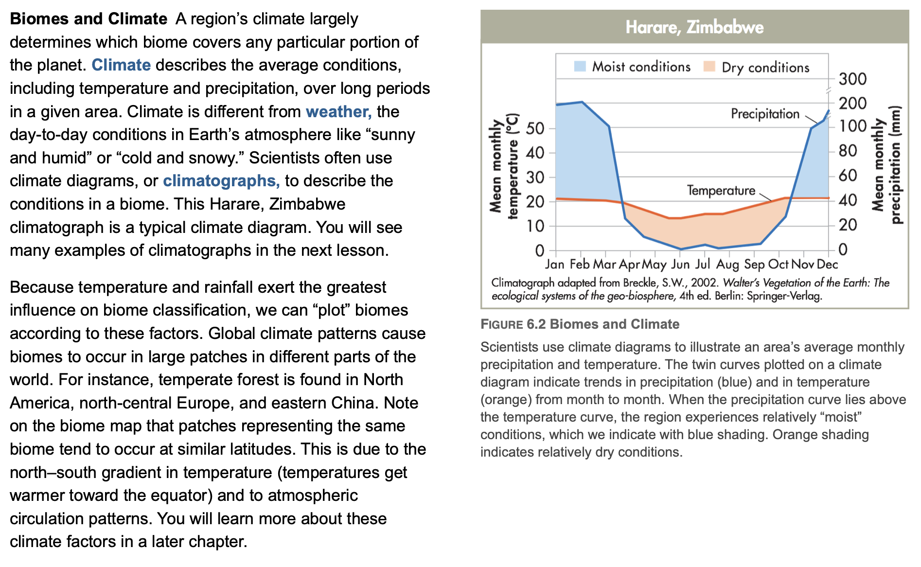
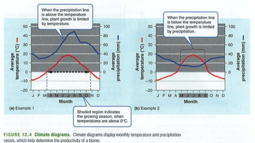
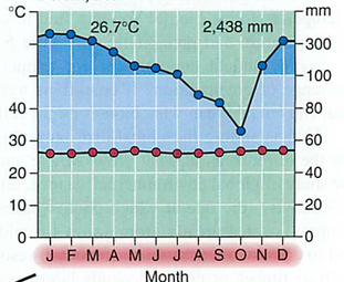
</div></div></div></div></div></div><div id="bkmrk-decoding-climatogram"><span style="font-weight: bold;">Decoding Climatograms:</span></div><div id="bkmrk-you-will-need-to-und">You will need to understand these when you create your green dream home:</div><div id="bkmrk-fce37.pngthese-diagr"><figure>![fce37.png](https://bookstack.kamuela.org/uploads/images/gallery/2026-09/IU5wOkkOD5F0cdpk-fce37-x1v89npw.png)<figcaption>fce37.png</figcaption></figure>  

- These diagrams are how climatologists describe biomes without a cool map.
- The blue line is the amount of rainfall, with units on the RIGHT side of the graph.
- The red line is the temperature, with units on the LEFT side of the graph.
- The shaded region in the months below (jfmamjjasond) is the growing season when temperatures are above freezing.
- When the precipitation line is above the temperature line, growth is limited by temperature (e.g. freezing).
- When the blue line is below the red line, growth is limited by precipitation (e.g. the desert).
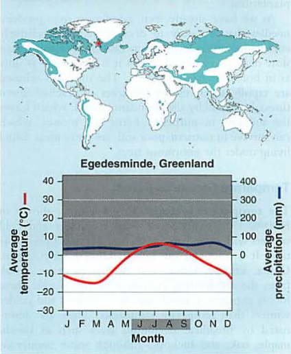
- Start with the north: Tundra is what you'd see in Alaska.
- Permafrost is soon to be in the news.
- It is made of permanently frozen ground a few feet below the surface.
- Even roots cannot penetrate it, so some trees grow in a stunted fashion.
- It is also composed of frozen organic matter, which when it melts will decompose, releasing CO2 and CH4 (methane), which is 20x as powerful as CO2 as a greenhouse gas.

</div><div id="bkmrk-tundra%3A-%28like-in-pal"><span style="font-weight: bold;">Tundra: (like in Palmer, Alaska, away from the water)</span></div><div id="bkmrk-2879f.pngnote-the-co"><figure>![2879f.png](https://bookstack.kamuela.org/uploads/images/gallery/2026-09/fitTdEluBIM232fQ-2879f-3olgpjn0.png)<figcaption>2879f.png</figcaption></figure>  
Note the cool temp, so growth is determined by temp, not rainfall. Lots of snow here, and little liquid water for plants, so yeah, mainly snow and glaciers.</div><div id="bkmrk-boreal-%28north%29-fores">  
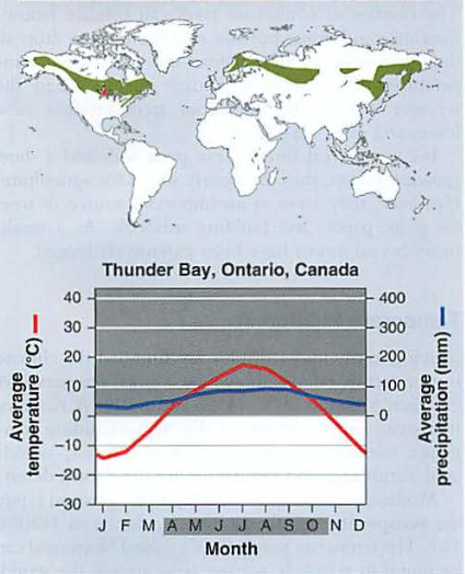
<span style="font-weight: bold;">Boreal (north) forest: (think of the aurora-lights, borealis-northern)</span>  
</div><div id="bkmrk-contrast-that-with-t">Contrast that with the boreal (north) forest:</div><div id="bkmrk-ea2c0.pngnote-the-sh"><figure>![ea2c0.png](https://bookstack.kamuela.org/uploads/images/gallery/2026-09/B5cklOq0jJnGAJOx-ea2c0-xna6sdv8.png)<figcaption>ea2c0.png</figcaption></figure>

- Note the short growing season.
- Any plants that survive usually have an oily sap (pine trees, evergreens) that does not freeze.
- Also note the serious cold in the winter-animals have to adapt to these (fur, hibernation, etc.)

<div><span style="font-weight: bold;">Temperate (mild) forests: (maybe Skagway, AK, on the water)</span>  
</div>

- Temperate (mild) forests are nicer, longer growing season, and rarely freeze.
- They are usually near the ocean, so they do not freeze (ocean is a huge heat sink).
- They often have lots of rain (think of Seattle).
- You may recall these are places where the surface parts of Ferrell and Polar cells converge, bringing in clouds and as these clouds rise into the atmosphere, they release their water as precipitation.

</div><div id="bkmrk-3e1cb.pngtemperate-%28"><figure>![3e1cb.png](https://bookstack.kamuela.org/uploads/images/gallery/2026-09/8dwmkXJgMtxBW0vm-3e1cb-ldmahkqn.png)<figcaption>3e1cb.png</figcaption></figure>  
<span style="font-weight: bold;">Temperate (mild) seasonal forest:</span>  
</div><div id="bkmrk-temperate-%28mild%29-sea">

- Temperate (mild) seasonal forest actually has seasons
- Deciduous trees can live here, like maple and oak. It gets close to freezing, but no real dry season.

</div><div id="bkmrk-8028b.png"><figure>![8028b.png](https://bookstack.kamuela.org/uploads/images/gallery/2026-09/PkrxyVoFUXSSohbe-8028b-ftgadt0s.png)<figcaption>8028b.png</figcaption></figure>  
</div><div id="bkmrk--4">  
</div><div id="bkmrk-woodland%2Fshrubland%C2%A0">  
<span style="font-weight: bold;">Woodland/shrubland</span></div><div id="bkmrk-is-like-much-of-sout">

- Is like much of southern California, or the Mediterranean.
- Wine can grow here. It is also known as the mediterranean (medi=middle, terra=earth) biome.
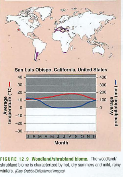
</div><div id="bkmrk-99264.pngnote-it-nev"><figure>![99264.png](https://bookstack.kamuela.org/uploads/images/gallery/2026-09/GnoaXEOfCL793q77-99264-gov9ierf.png)<figcaption>99264.png</figcaption></figure>Note it never really freezes, but growth is determined by precipitation (blue line is below the red line). This is also known as "chaparral" or the "fynbos" or "nice forest" in Afrikaans (South Africa). Look up the main wine regions of the world, they will fit this biome. Also consider how many Italians could start vineyards in northern California...</div><div id="bkmrk--5">  
</div><div id="bkmrk-temperate-grassland%2F">  
<span style="font-weight: bold;">Temperate grassland/cold desert:</span></div><div id="bkmrk-is-a-dry%2C-grassy-are">

- Is a dry, grassy area, like Oklahoma, although it does get very cold there, so think more of Texas, or the Gobi desert.
- Again, growth is rain limited: (you may recall these are near Hadley/Ferrel cell subsidence, so dry air from space falls here).
- These areas tend to be far from large bodies of water, so they have more extreme temperatures than similar latitudes near water (e.g. Italy, France, California)

</div><div id="bkmrk-7e59f.pngtropical-ra"><figure>![7e59f.png](https://bookstack.kamuela.org/uploads/images/gallery/2026-09/skn9rKrLs5AANEz3-7e59f-qpdaqtm3.png)<figcaption>7e59f.png</figcaption></figure>  
<span style="font-weight: bold;">Tropical rainforest</span></div><div id="bkmrk-is-the-rainiest-of-t">

- Is the rainiest of them all, and much of our island has this near the shore.
- Warm temperatures, and paradoxically poor soil nutrition (all of the nutrients are in the plants).
- On Mt. Waialeale on Kauai, the rainfall is 480 INCHES per year, 2.5 times as high as the high point on the chart below:
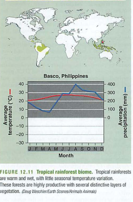
</div><div id="bkmrk-4d9c8.pngsavanna-or-"><figure>![4d9c8.png](https://bookstack.kamuela.org/uploads/images/gallery/2026-09/NEv7NeKwxMpZ2qwA-4d9c8-rhdowovz.png)<figcaption>4d9c8.png</figcaption></figure><span style="font-weight: bold;">Savanna or tropical seasonal forest:</span>  

- Africa and Brazil hold the next biome: <span style="font-weight: bold;">Savanna or tropical seasonal forest</span>.
- Think of Madagascar (the film): not many large trees, room for animals to roam, lots of grass, happy lions, maybe a bossy penguin or two...Growth dependent on rainfall: (blue line below red one)

</div><div id="bkmrk-95665.pngsubtropical"><figure>![95665.png](https://bookstack.kamuela.org/uploads/images/gallery/2026-09/4dwy7BPtoU7qQ62H-95665-j5pvct6d.png)<figcaption>95665.png</figcaption></figure>  
<span style="font-weight: bold;">Subtropical desert biome</span>  
</div><div id="bkmrk-finally%2C-the%C2%A0subtrop">

- Finally, the <span style="font-weight: bold;">subtropical desert biome</span>, like what you'd see in the Sahara desert (another film), or most of Australia, the Atacama in Chile, the Mojave desert in California, and some of Mexico.
- Note the Gobi desert is not on this list-too cold. Again, note these areas are where dry air subsides (falls) from the Hadley and Ferrell cells.
</div><div id="bkmrk-c48f1.pngmajor-human"><figure>![c48f1.png](https://bookstack.kamuela.org/uploads/images/gallery/2026-09/8Aaab6qTjjN0g8GN-c48f1-xruegy9s.png)<figcaption>c48f1.png</figcaption></figure><span style="font-weight: bold;">Major Human Impacts by Biome</span>

<span style="font-weight: bold;">Tundra</span>: Oil &amp; gas drilling, pipelines, mining scars; melting permafrost releases greenhouse gases.

<span style="font-weight: bold;">Boreal Forest (Taiga)</span>: Logging, oil extraction, mining; climate change → fires &amp; pest outbreaks.

<span style="font-weight: bold;">Temperate Forest</span>: Deforestation, urban expansion, pollution (acid rain), invasive species.

<span style="font-weight: bold;">Seasonal Temperate Forest</span>: Habitat fragmentation, overhunting, climate change alters cycles.

<span style="font-weight: bold;">Woodland–Shrubland</span>: Urbanization &amp; wildfires, overgrazing, agriculture (vineyards/olive groves).

<span style="font-weight: bold;">Temperate Grassland</span>: Converted to cropland, overgrazing causes erosion, fire suppression alters

balance.

<span style="font-weight: bold;">Tropical Rainforest</span>: Deforestation for logging, cattle, palm oil; mining &amp; roads reduce biodiversity.

<span style="font-weight: bold;">Tropical Soils</span>: Slash-and-burn, monocultures deplete nutrients, fertilizer runoff pollutes water.

<span style="font-weight: bold;">Savanna</span>: Poaching, overgrazing → desertification, fire suppression disrupts ecosystem.

<span style="font-weight: bold;">Subtropical Desert</span>: Off-road vehicle damage, urban sprawl, water depletion from irrigation.

<span style="font-weight: bold;">Aquatic Biomes</span>: Pollution (plastic, fertilizer), overfishing, dams alter rivers, ocean acidification.

<span style="font-weight: bold;">Chesapeake Bay</span>: Agricultural runoff → eutrophication, overfishing, sediment pollution, sea level rise.


[Download Biomes\_Study\_Sheet\_with\_Human\_Impacts.pdf (application/pdf, 4.5 KB)](https://bookstack.kamuela.org/attachments/240)

## Biome Game:

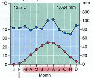
Clues:</div><div id="bkmrk-cffbb.pngfind-these-"><figure>![cffbb.png](https://bookstack.kamuela.org/uploads/images/gallery/2026-09/wyT6IHZ0SrKAaPub-cffbb-cin4uwtv.png)<figcaption>cffbb.png</figcaption></figure><span style="font-weight: bold;">Find these places in the first three climatographs: </span>Philadelphia, PennsylvaniaSan Diego, CaliforniaBelem, Brazil  
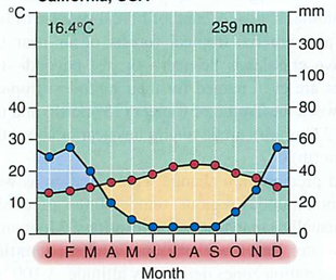
  
<figure>![de227.png](https://bookstack.kamuela.org/uploads/images/gallery/2026-09/ltL8Fju2cT3UfVcH-de227-vcdahv4i.png)<figcaption>de227.png</figcaption></figure>  
<figure>![9139d.png](https://bookstack.kamuela.org/uploads/images/gallery/2026-09/538A8JtpwcQ8BRFp-9139d-u50c6fzy.png)<figcaption>9139d.png</figcaption></figure>  
<figure>![86a5a.png](https://bookstack.kamuela.org/uploads/images/gallery/2026-09/J3l0KjWUXEmmxo7x-86a5a-ka0b48mo.png)<figcaption>86a5a.png</figcaption></figure>[Download Find these biomes below:.pdf.pdf (application/pdf, 980.2 KB)](https://bookstack.kamuela.org/attachments/231)

Google this: [aquatic biome game](https://www.google.com/search?client=safari&rls=en&q=aquatic+biome+game&ie=UTF-8&oe=UTF-8)</div>---

<small>Migrated from Apple Server Wiki. Original page ID: V5v9M8</small>