# 24.10.15 Aquatic biomes
Google [aquatic biome game](https://www.google.com/search?client=safari&rls=en&q=aquatic+biome+game&ie=UTF-8&oe=UTF-8)
Recall terrestrial biomes are defined by temperature and precipitation (rain)
Aquatic biomes are by definition underwater, so they are defined by
- Depth: how deep is the deepest part, how much photosynthesis is possible
- Distance from shore: shallow water has more life, more things to attach to, more biodiversity
We separate aquatic biomes into freshwater (lakes, rivers, streams) and saltwater (oceans, estuaries)
Freshwater biomes:
Riparian=river
Limnotic=lakes
Lakes:
- Shallow shore area=littoral (means shallow), see the "littoral Navy", photosynthesis here (shallow, light shines through)
- Open water area=limnetic zone, no rooted plants (too deep), phytoplankton here, only as deep as sunlight can penetrate
- Deep water=profundal ("profound") or deep zone: no light penetrates, bacterial decomposition.
- Bottom=benthic zone: mud, dark, cloudy
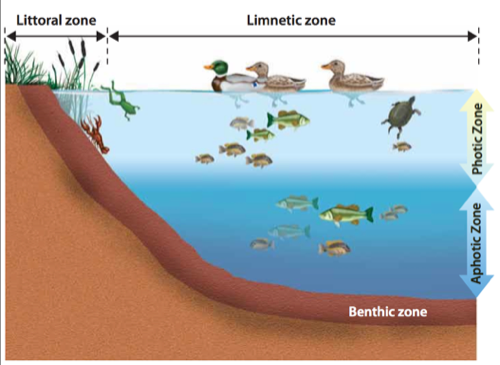47fc3.pngPonds are much smaller, and may freeze in the winter, so their dynamics are different
Productivity: see also NPP (net primary productivity)
- n.b. usually related to photosynthesis (plants)
- Oligo (few) trophic=low productivity
- Meso (middle) trophic=medium
- Eutrophic (eu=good trephien=food)=lots of productivity (sometimes too much, like in "Poisoned Waters")
- Freshwater wetlands-submerged most of the time (swamps, marshes, bogs) this is the history of all coal and oil we now use
Wetlands:
- Freshwater wetlands-submerged most of the time (swamps, marshes, bogs) this is the history of all coal and oil we now use
- Salt marsh: usually connected to the sea, act as a coastal buffer for Hurricanes, very productive, many nutrients, lots of organic material
- Mangrove swamp: special adapted version of this in Tropical areas (e.g. Florida)
- Intertidal zone: area between high and low tide or seasonal variations
Ocean zones:
- Coral reefs-see coral bleaching, pH, temperature and salinity sensitive (see Hamakua coast vs. Puako)
- Intertidal zone: between high and low tide
- Photic (light) zone-shallow, photosynthesis, kelp, others
- Aphotic (dark) zone-too dark for photosynthesis
- Chemosythesis/thermosynthesis: deepwater steam vents, based on Sulfur instead of Oxygen, bacteria generate energy with methane (CH4) and H2S (instead of H20)
- Benthic=deep ocean
- Pelagic=open ocean (think of big sailing ships, whales, stuff like that)
- Hadal zones: like Hades: deepest, darkest zones. Weird fish, no light...
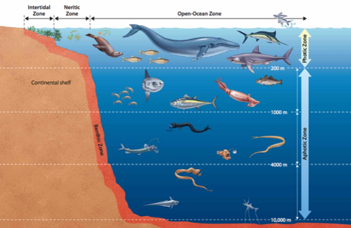b3276.pngSummary: (note open ocean is called Pelagic, and deep ocean zones are called Hadal)
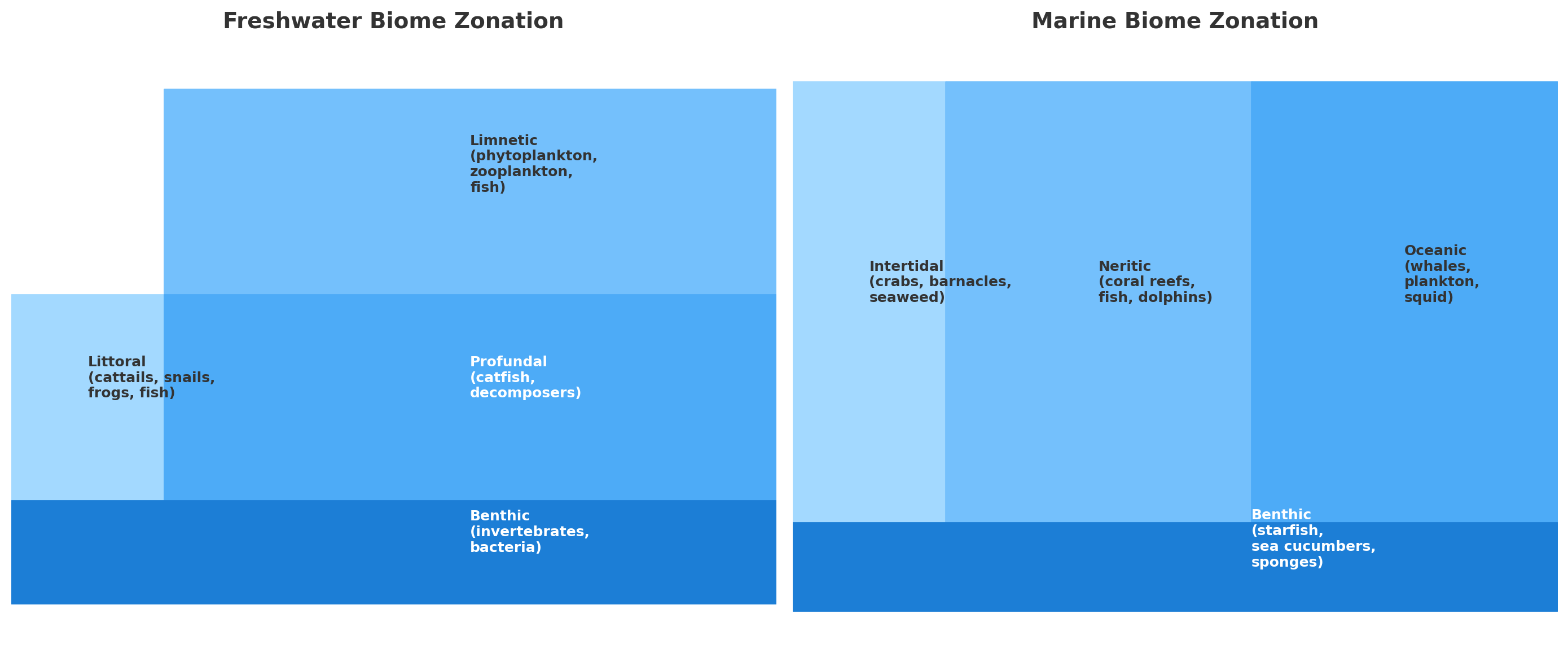Marine Biome Zonation.png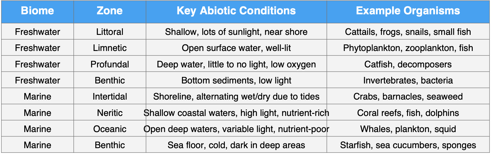Screenshot 2025-09-22 at 3.49.56 PM.pngSalt stuff:
- salt water = 30-50 ppt (parts per thousand)
- know what these mean, we will see them soon: ppt, ppm, ppb
- fresh water = 0.5 ppt
- in between 0.5-30 ppt = brackish (anchialine ponds in Kona)
- salinity, wind and temperature determine flow
==================Terms to know: Review
Zones:
photic zone=light
aphotic=no light
benthic=really no light, never, ever ever. don’t even think about it.
Hadal=too dark to imagine, named after Hades (hell)
Marine animals:
- aquatic mammals must surface for air
- fishies don’t-they have gills
- DO dissolved oxygen (very important) depends on plants (so depth) and temp (cooler water can hold more O2)
- warm water has low O2 generally.
- best place to fish: cool water after a waterfall (why?)
Rivers, ponds and lakes, oh my...
- flowing water: rivers
- standing water: ponds
- lakes can become inland seas (drought lowers level, unable to drain, forms a lake)
- littoral=shore, limentic=away from shore benthic=botttom
Wetlands:
- terms: marshes, swamps, bogs and fens
- marshes marshes marshes!-tall grasses
- swamps-some trees
- bogs-acidic, poor decomposition, floating stuff, decay slowly-ancient cheese story, peat moss
- fens-freshwater spring underneath, less acidic, better nutrients
River stuff:
- rivers-"oxbow" lakes and meander (usually in very flat lands like Nebraska)
- continuity concept: source->tributary->mouth (delta)
- slope exponential as distance from source (one reason dams do not last long)
- deposition rates (rapids vs. plains, think of sedimentation)
- silt carrying capacity, turbidity
- estuaries-like deltas
- tidal estuary: e.g. hudson river: deeper than the body it serves
Oceans——
- 200 ft. of salt if all oceans evaporated
- oceans were red (iron) then ppt out (iron range in WI, MI) (see PBS Nova episode)
- salinity, wind and temperature determine flow
- upwelling (recall Peruvian fisherpersons)
- also downwelling
Photic (light) zones-again
- intertidal zone-makes sense, between tides
- neritic zone-close to shore, less than 200 ft. deep (not in Hawaii, we have no continental shelf-boo hoo)
- open ocean (pelagic) zone
- kelp forests-e.g. california coast
- coral reefs-away from fresh water, coastal, photic
- open ocean-scary stuff
---
Migrated from Apple Server Wiki. Original page ID: X8680818