# Modules 9-11 Heat Energy: air and water
Modules 9-11: Heat Energy: air and water
(fun with globes)
Modules 9-11 FR 3e (also module 22 in FR 4e)
Heat
Heat energy always moves from hot to cold (high energy to lower energy)
Heat energy moves in three "modes":
- conduction: from the latin word for "contact", objects touching
- convection: matter in motion, like hot air or steam rising
- radiation: infrared radiation below visible light on the spectrum
Conduction:
Materials can be excellent conductors of heat like silver, aluminum, copper and gold
Fun fact: Materials that are good conductors of heat are also good conductors of electricity
Insulators are materials that do not conduct well: styrofoam, pink panther insulation, cloth, rubber
Think of this: to pick up something very hot, what would you hold it with?
Convection:
Hotter fluids are less dense than cooler ones, causing upward migration of hot material
Fun fact: everything in zero gravity needs a fan to cool (why?)
Convection can be blocked by covering hot objects, like the cover on your coffee or pot on the stove
You may have seen strange mirage like waves over something hot: this is convection of less dense air bending light
Radiation:
This is basically light, so can be reflected by foil, or any reflective material
Radiation is most effective at higher temperatures, one reason you can't see warm objects but can see red hot objects
This is also how snakes and other reptiles (or the alien in predator) see the tracks of their prey
This is one reason hot drinks are usually delivered in white cups: white reflects radiation better than black, which absorbs and re-radiates the energy (one part of the greenhouse effect)
Note that these are not the key ways your body cools during exercise: that is called "latent" (hidden) heat of vaporization
- When sweat evaporates, it takes with it lots of energy to do so, cooling you very efficiently
- Consider why some triathletes who come for the Kona Ironman (or others) have trouble here with the high humidity
- Higher humidity means less efficient evaporation.
- It also explains why 110°F in Phoenix might be tolerable if the humidity is very low
Lab: Heat transfer
1. choose a cup or other container for testing
2. measure room temperature with temp sensor
3. fill container with hot water, measure with temp sensor
4. measure regularly as heat escapes from your container
5. repeat after modifying to block conduction, convection and radiation
Module 9: Heating of the earth
Radiation from the sun hits the surface of the earth, which re-radiates this energy as longer wavelength infrared radiation.
(There is some heating of the atmosphere in both directions)
The atmosphere is divided into layers based on temperature, gases and density:
- Troposphere: at the surface, where all the action is
- ozone layer-blocks UV light
- Stratosphere: where planes fly: cooler
- Mesosphere: "middle" layer
- Thermosphere: "hot" layer, fast (3/2kT) molecules (from radiation), low pressure
- Exosphere: very low density, lots of radiation
(see layer diagram)
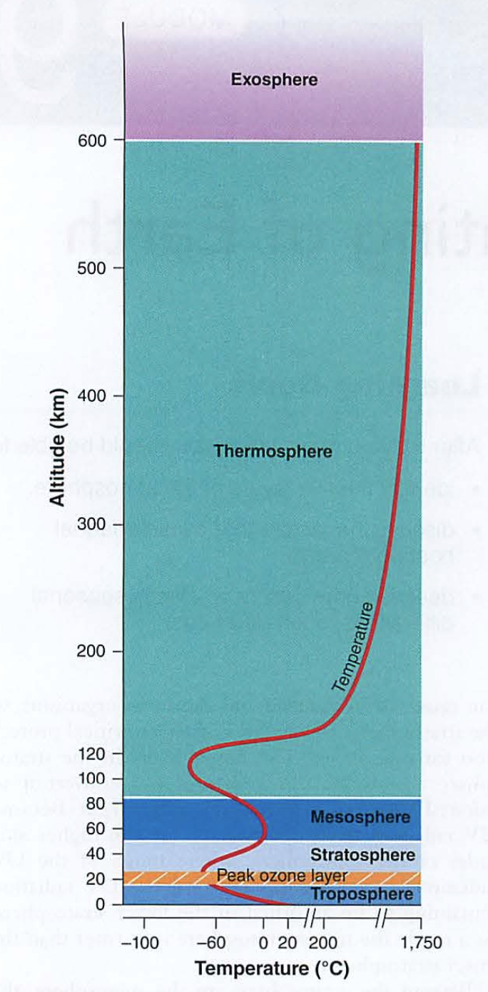Screenshot 2023-09-28 at 10.53.35 AM.pngn.b. thermosphere is also known as the ionosphere (reflects radio waves), blocks nasty radiation from space, absorbs the energy from this radiation, gets hot
Now think of the three heat transfer modes:
Radiation: energy from the sun hitting the surface
Conduction: hot ground heats the air in contact with it
Convection: hot air rises, creating weather
Weather?
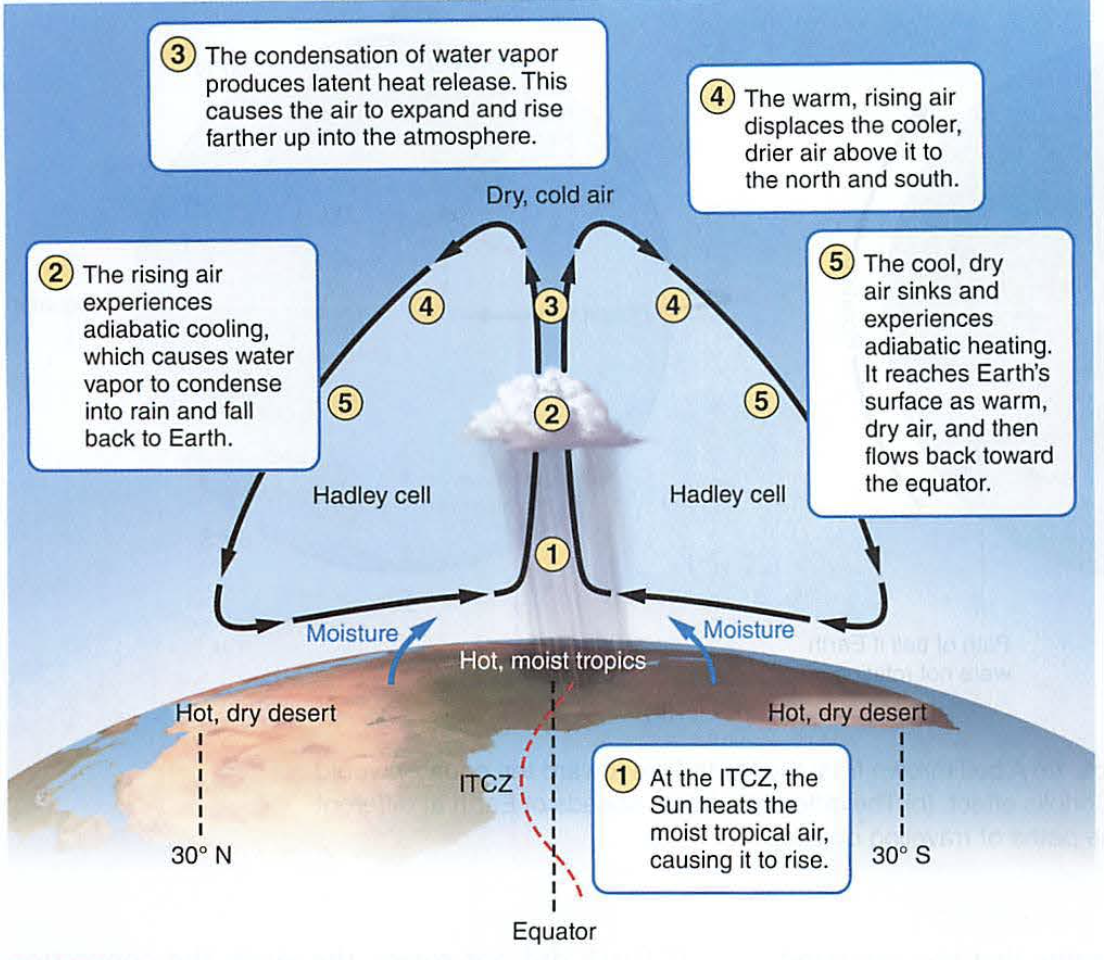
As air rises, it creates local low pressure areas, bringing in clouds and moisture (wind)
As this air rises, it cools, dropping moisture as rain or snow
This dry air circulates at high altitude until it transfers its heat to space (radiation and conduction) then descends as cooler, dry air
(see adiabatic cooling diagram)
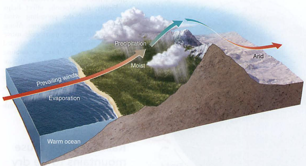
Screenshot 2023-09-28 at 10.54.41 AM.pngThis also happens if moist air is forced over a mountain range (remember the Waipio question?)
(see rain shadow diagram, module 22 FR4e)
Screenshot 2023-09-28 at 10.55.20 AM.pngThe amount of heat the surface absorbs is based on reflectivity (recall radiation above)
Albedo is a measure of this reflectivity (think of Albus Dumbledore: white beard)
- Average albedo for the earth is about 30%
- Snow and ice are about 90%
- Water is about 35%
- Soil is about 15%
- Asphalt is about 5%
- Clouds vary in density from 10-90%
(see albedo diagram)
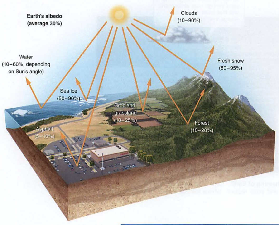Screenshot 2023-09-28 at 10.56.07 AM.pngFun fact: as global warming melts ice (high albedo) it turns into water (lower albedo), warming the planet more (positive feedback).
The place on the planet with the most average solar radiation is the equator, so air rises there (convection)
This creates the first of three cells: the Hadley cell
- As air moves towards the equator, it brings moisture (ITCZ)
- As this moist air rises, it cools and rain results
- The resulting dry air moves north and south away from the equator in the stratosphere
- This dry air descends creating deserts
Fun fact: on windy trade wind days your flight to the mainland is faster-why?
(see Hadley cell diagram)
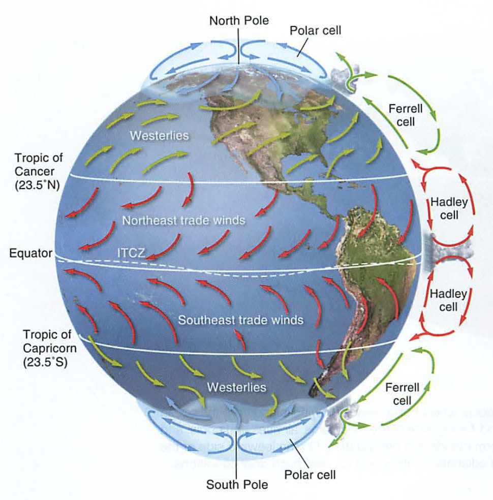Screenshot 2023-09-28 at 10.56.49 AM.pngPrimitive meteorologists (weather folks) detected three of these cells:
- Hadley
- Ferrell
- Polar
To draw these, remember that when cells touch, air moves in the same direction: up-up or down-down
Biome impact: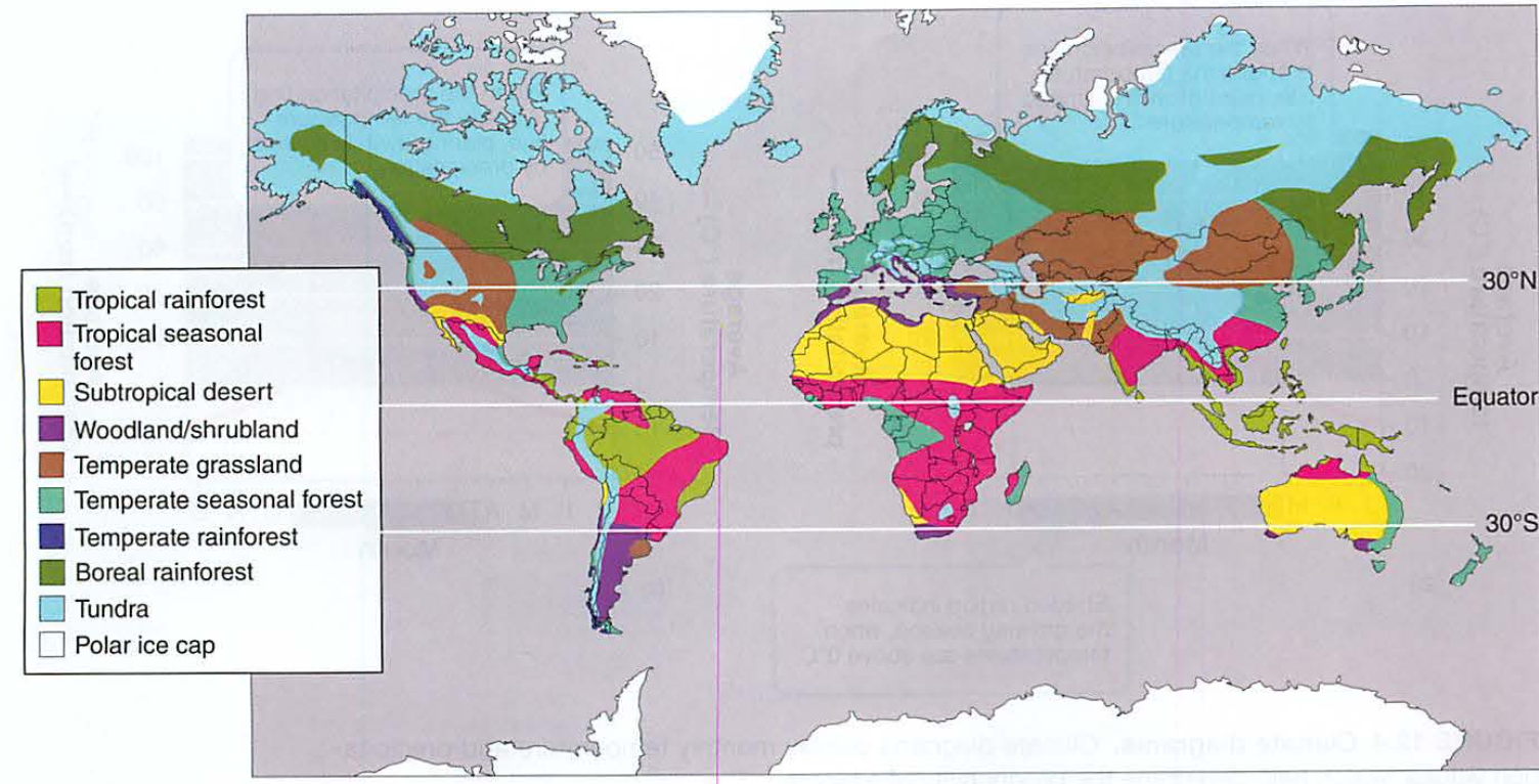Screenshot 2023-09-28 at 11.08.21 AM.pngSeasons:
The earth is tilted on its axis about 23.5° (get over it, it changes every 20,000 years)
Because of this, each hemisphere gets more or less solar radiation at certain times of the year.
We divide this (almost)circular motion into 4 points:
- Summer solstice: June 21 (summer for N hemisphere)
- Autumnal equinox ("equal night"): September 21 (today!)
- Winter solstice: December 21 (winter for N hemisphere)
- Vernal or spring equinox: March 21 (pagan festivals, etc.)
Australians have Christmas in their summer. Santa arrives by surfboard (true fact)
Fun fact: Pagans feared each winter that the days would just keep getting shorter and total darkness would result, so when they calculated winter festivals, they waited a week after the darkest day (December 21) to make sure the sun would come back.
This is why Christmas is December 25, not 21.
(see season diagram)
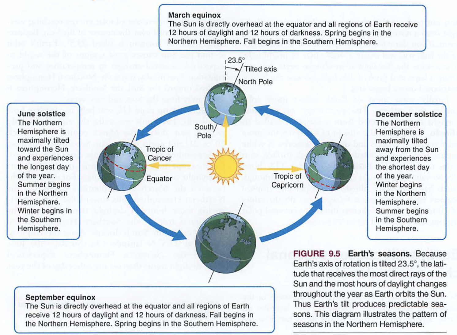Screenshot 2023-09-28 at 10.57.55 AM.pngIn Hawaii, we are below 23.5° latitude (find this on your globe), so for several months in our summer, the sun is actually NORTH of straight overhead. This is called "Lahaina noon".
Coriolis effect:
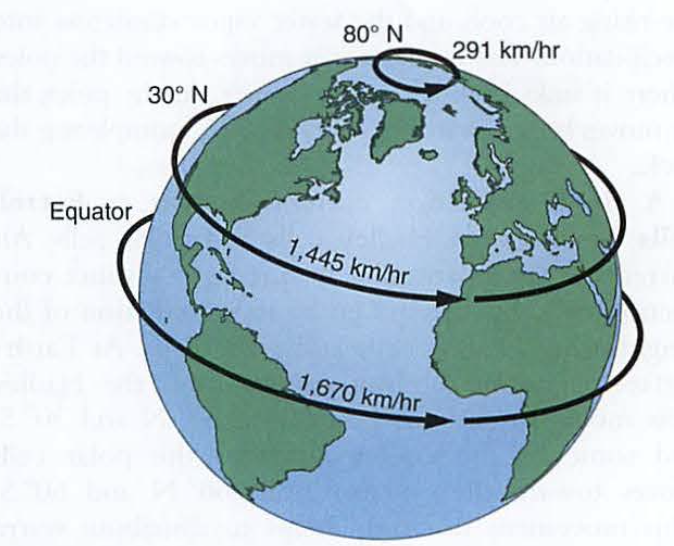
If you look at your globe from above (like some eskimo god), you will notice the radius at the equator is greater than at higher latitudes.
Actually, the tangential velocity (physics term) at the equator is about 1600 km/hr (1000 mph), while it is zero at the north pole.
As large storms stretch out with one end more south than the rest, it falls behind, creating the coriolis effect.
Demo: imagine dripping water (you, the eskimo god again) on the globe while it spins, which way would the water drip?
Screenshot 2023-09-28 at 10.58.33 AM.pngOceans: wind and water
Surfers in California usually wear wetsuits.
Why?
Water along the California coast travels south from Alaska.
Remember this: oceans in the northern hemisphere travel clockwise
(opposite in the southern hemisphere)
Tough question: why are our trade winds from the NE not the North (Hadley cell)?
Verify on windy.com:
[https://www.windy.com/?20.002,-155.533,5](https://www.windy.com/?20.002,-155.533,5)
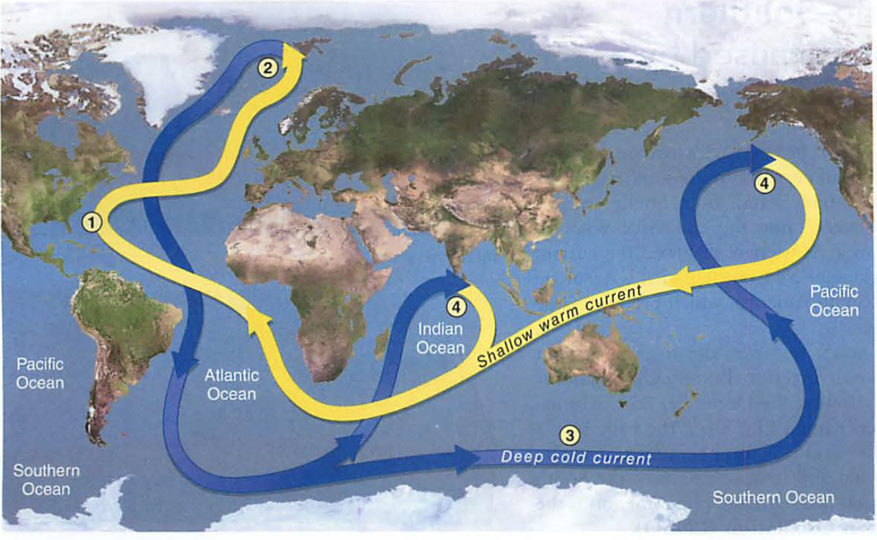
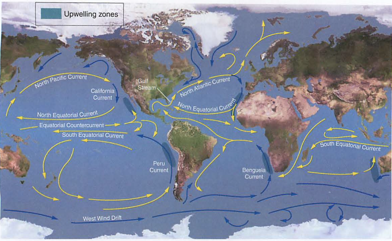Screenshot 2023-09-28 at 10.59.05 AM.pngThere is one very interesting deep ocean current called the "thermohaline" circulation:
thermo=heat, haline=salty
Also known as the NADW or North Atlantic Deep Water:
Melting ice sheets in Greenland create dense, cool water that flows south along the ocean floor, and emerges in two places on the planet: India and KONA!
Screenshot 2023-09-28 at 10.59.30 AM.pngOcean circulation: Up and down
The Andes run north and south from Peru to Chile as a result of tectonic plates going under South America from the west (more on this soon).
As a result, there is a deep trench off the coast of Peru and Chile
Looked at sideways from the south, as water rises from this deep trench it brings with it decomposed ocean creatures (detritus) that surface fish love to eat: happy fisherpeople
For this to happen, an offshore wind has to be strong.
This condition is called La Niña, and is an indicator of weather all over the planet
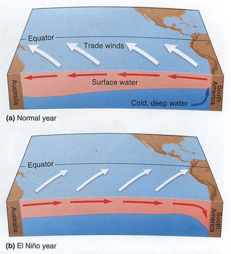Screenshot 2023-09-28 at 11.00.02 AM.pngEl Niño is when this wind becomes onshore, stopping the migration of fish food (sad fisherpeople)
(see sideways diagrams of La Niña and El Niño)
Better picture:
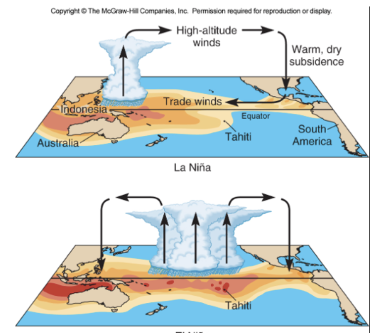Screenshot 2023-09-28 at 11.01.19 AM.png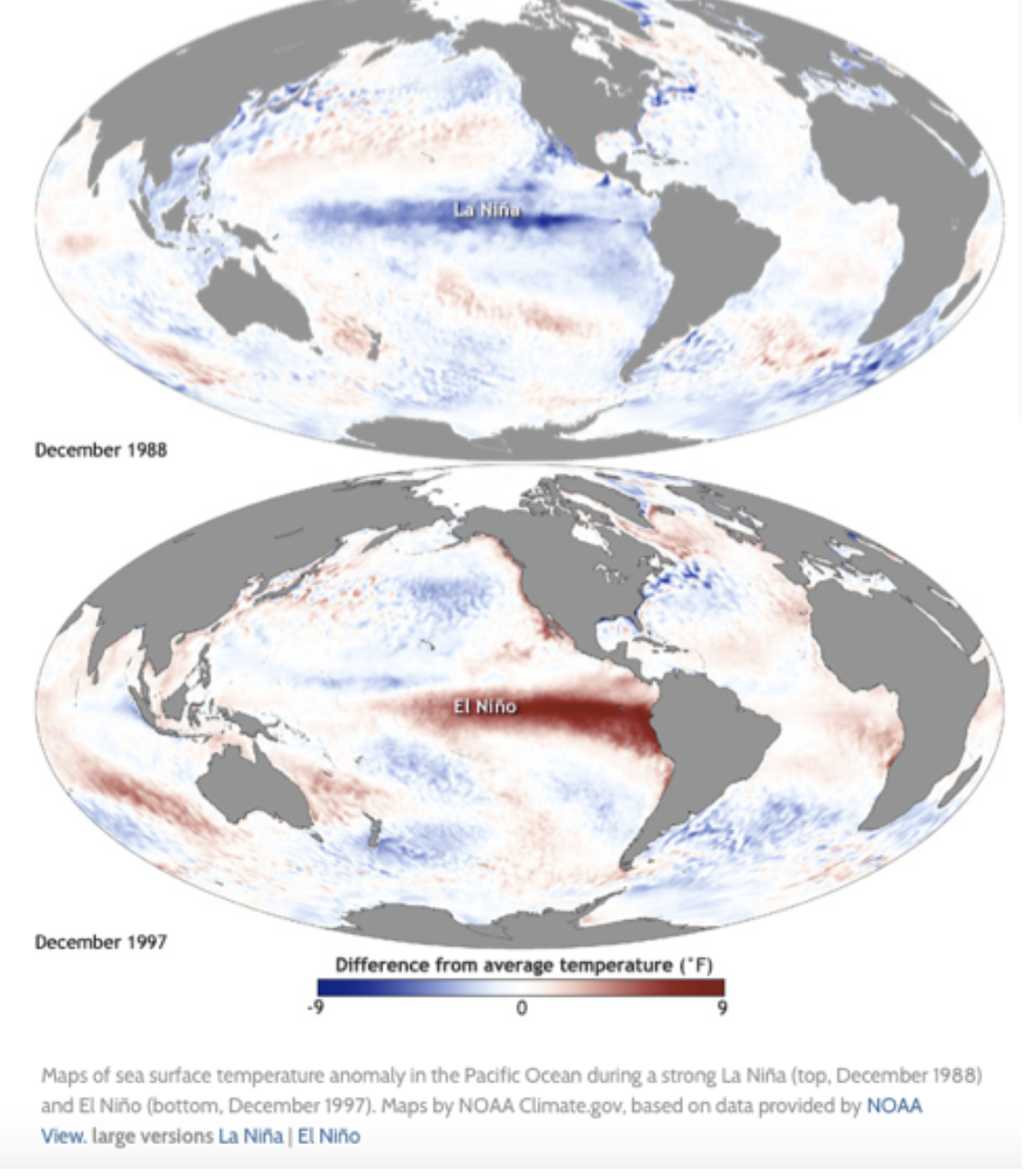Screenshot 2023-09-28 at 11.03.08 AM.png
---
Migrated from Apple Server Wiki. Original page ID: J5j9j2m