# Island Science - Migration Test
Temporary test migration from Apple Server Wiki
# Lab 00-intro to island science
**Welcome!
This is a relatively new course, so we get to create as we go along.
First, here is our course description:
**Course Outline:
Only on our island can we explore all of these in one place:
- **Earth**: earthquakes, volcanoes, geothermal energy
- **Ocean**: tsunamis, ocean energy, aquaculture, physical oceanography
- **Atmosphere**: climate change, air quality, vog
- **Stars**: astronomy, astrophysics, **space weather,** Polynesian navigation
This hands-on course will enable you to explore these with direct access to tools, sensors and experts on our island including Observatories on Mauna Kea, Mauna Loa, Hawaii Volcanoes and research at NELHA and the Pacific Tsunami Warning Center among others.
As a survey course, this is an excellent preparation for any college level science course in these fields beyond the scope of normal science courses.
Ok…
You may notice a theme of exploration. This is how we will approach island science, creating and using tools to explore.
Our goal therefore is to expand your curiosity and experience as an explorer.
**Class format/expectations:
We will meet about three times each week in the energy lab at the top of campus. You can walk across the troll bridge, or up the road from GPAC, up to you. We start class on time, and make sure to bring your charged laptop and phone to class.
We may be out in the field at times, and if we need to go far, like into the garden, I’ll try to give you warning so you wear appropriate attire.
We may also use a weblog to record your explorations, which will help you in creating future projects, but also help other students following in your explorations.
We may be using serious tools for our work-you are expected to treat these with respect, and don’t abuse the privilege of access. This also goes for internet and network use: if it violates the school acceptable use policy, you probably should think twice.
If you find anything either in our discussions or in the material makes you uncomfortable, please reach out to me. My goal is to be inclusive and respectful of all viewpoints. This does not mean we’ll challenge accepted scientific principles like “did we really land on the moon” or “is climate change caused by human activity”.
**Grading**:
We’ll sort out the best way for you to record your progress as an explorer. I like the idea of logs, just like any other explorer, tracing your journey for others to follow. We can decide this as a group about this when we meet. Your participation and ability to record your journey are what is important. I’m a big fan of ownership: whatever you do here should be yours forever, not just until some huge exam.
**Energy Lab:** Please do not bring food or drink from outside into the energy lab. Students may bring in their own water containers, but since we have a limited supply of bottled water, please do not fill your containers from these bottles, instead use the water in the sinks, which is actually purified rainwater.
**Access**:
The best way to reach me is before or after class, but any questions about grading has to be taken care of outside of our class time, out of respect for others in the class as well as your privacy. My email is bill@hpa.edu, and I can answer your responses up until about 7 PM most evenings.
---
Migrated from Apple Server Wiki. Original page ID: F850x2x5
# Lab 01b: navigation: mapping resources
Welcome to your Island Science home page!
Make sure to read the latest [documents](http://10.14.4.85:6875/books/island-science-migration-test/page/lab-01b-navigation-mapping-resources) (above, right side)
- Check out these maps:
- [https://geoportal.hawaii.gov/datasets/cchnl::elevation-1/explore?location=19.997731%2C-155.646395%2C12.87](https://geoportal.hawaii.gov/datasets/cchnl::elevation-1/explore?location=19.997731%2C-155.646395%2C12.87)
- Contour maps:
- [https://geoportal.hawaii.gov/datasets/HiStateGIS::hawaii-elevation-contours-100ft/explore?location=20.015732%2C-155.673924%2C13.00](https://geoportal.hawaii.gov/datasets/HiStateGIS::hawaii-elevation-contours-100ft/explore?location=20.015732%2C-155.673924%2C13.00)
- Celestial Navigation:
- [https://en.wikipedia.org/wiki/Celestial\_navigation](https://en.wikipedia.org/wiki/Celestial_navigation)
- [https://www.nps.gov/teachers/classrooms/make-your-own-astrolabe.htm](https://www.nps.gov/teachers/classrooms/make-your-own-astrolabe.htm)
## Additional migrated files
Files present in the Apple export but not embedded in a page:
- [Download IMG\_0811.jpeg (image/jpeg, 3.0 MB)](https://bookstack.kamuela.org/attachments/1)
- [Download javier.jpg (image/jpeg, 7.0 MB)](https://bookstack.kamuela.org/attachments/8)
- [Download isci 2025.jpeg (image/jpeg, 4.1 MB)](https://bookstack.kamuela.org/attachments/19)
- [Download image.png (image/png, 2.9 MB)](https://bookstack.kamuela.org/attachments/21)
- [Download IMG\_3950.MOV (video/quicktime, 20.6 MB)](https://bookstack.kamuela.org/attachments/25)
- [Download Screenshot 2025-09-17 at 12.43.28 PM.png (image/png, 4.4 MB)](https://bookstack.kamuela.org/attachments/26)
- [Download Screenshot 2025-10-18 at 6.21.02 AM.png (image/png, 2.7 MB)](https://bookstack.kamuela.org/attachments/27)
- [Download Haplogroup - Wikiwand.pdf (application/pdf, 3.3 MB)](https://bookstack.kamuela.org/attachments/28)
- [Download Screenshot 2026-02-04 at 6.29.43 AM.png (image/png, 780.7 KB)](https://bookstack.kamuela.org/attachments/31)
---
Migrated from Apple Server Wiki. Original page ID: F2j1y2S5g
# Lab 10a: Lava Flows
[Simulations:](https://elab.hpa.edu/isci/sims/?target=)
[Lava Flow map](https://elab.hpa.edu/isci/sims/lava-flow-map.html?target=)
[Lava Flow simulator](https://elab.hpa.edu/isci/sims/lavaflow.html?target=)
---
Migrated from Apple Server Wiki. Original page ID: X1M7P9N
# Lab 02: navigation: reading maps
Check out these maps:
[https://geoportal.hawaii.gov/datasets/cchnl::elevation-1/explore?location=19.997731%2C-155.646395%2C12.87](https://geoportal.hawaii.gov/datasets/cchnl::elevation-1/explore?location=19.997731%2C-155.646395%2C12.87)
Contour maps:
[https://geoportal.hawaii.gov/datasets/HiStateGIS::hawaii-elevation-contours-100ft/explore?location=20.015732%2C-155.673924%2C13.00](https://geoportal.hawaii.gov/datasets/HiStateGIS::hawaii-elevation-contours-100ft/explore?location=20.015732%2C-155.673924%2C13.00)
[Download 19320\_BookletChart.pdf (application/pdf, 6.8 MB)](https://bookstack.kamuela.org/attachments/10)
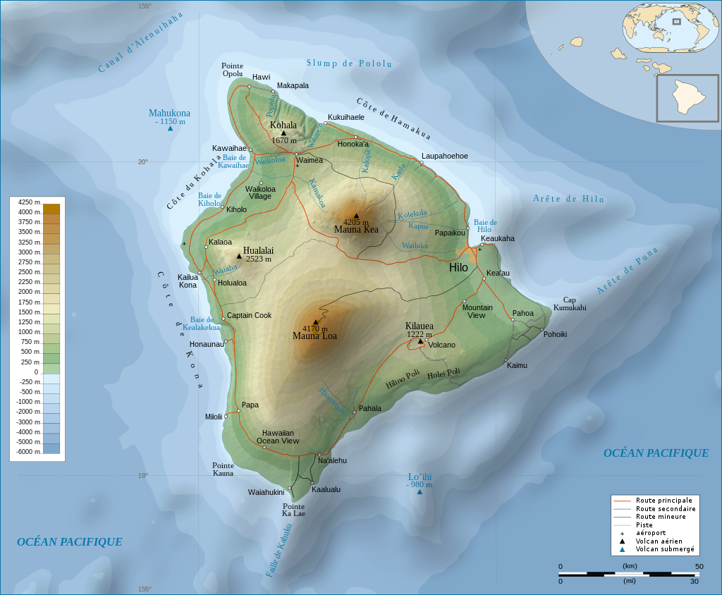1024px-Hawaii\_Island\_topographic\_map-fr.svg.pngHow to read contour maps:
- lines are at one level
- A shapes are rivers uphill
- circles are peaks
- many parallel lines is a flat slope
- V shapes are usually peaks
- no lines means a plain or flat surface
- steeper slopes have many line parallel, bunched together
The peaks we use are as follows: (Pu'u is the Hawaiian word for peak)
Pu'u Ha
Pu'u La'e La'e
Pu'u Hoku ula
The mountains we will use are some of the five major volcanoes on our island:
Mauna Kea ("white mountain")
Mauna Loa ("long mountain")
Hualalai
Kohala
Kilauea
Questions:
1. on a contour map, if parallel lines are close together, what feature is this?
2. you see V shaped lines moving from a peak to lower altitude, what is this?
3. same question, only backwards, inverted V
4. what do peaks look like on a contour map?
Finding yourself on the map:
1. hold your pencil on the peak you have sighted
2. calculate the degrees the peak would see you: if less than 180°, then add 180°, if more than 180, subtract 180.
3. from the peak set your compass on the peak and rotate until the degrees from north (vertical lines on the map) align with your number
4. draw a line backwards from that point
5. where at least three lines intersect, this is where you are
Finding a lost person:
You are injured in the rain forest, and have only a little battery left on your phone. Your GPS is not working since the rain forest blocks the signal, but you can see three peaks, and you can call 911, but only briefly.
Measure the compass heading to each peak, and tell the 911 folks where you are.
Help should come soon!
Below are photos of the information 911 received. Your job is to find your lost classmates:
---
Migrated from Apple Server Wiki. Original page ID: x5e2H8S
# Lab 01c: navigation: celestial navigation overview
[https://en.wikipedia.org/wiki/Celestial\_navigation](https://en.wikipedia.org/wiki/Celestial_navigation)
Main points:
An astrolabe is a device for measuring altitude of objects, or the angles of stars or planets for navigation. You can make your own using a protractor, a straw, some tape, dental floss and a rock or weight (see below):
[http://www.hmdt.org.uk/STEM\_lesson\_plans/2%20Physics/2%20Hypatia/3%20Make%20an%20Astrolabe%20Worksheet.pdf](http://www.hmdt.org.uk/STEM_lesson_plans/2%20Physics/2%20Hypatia/3%20Make%20an%20Astrolabe%20Worksheet.pdf)
[https://www.nps.gov/teachers/classrooms/make-your-own-astrolabe.htm](https://www.nps.gov/teachers/classrooms/make-your-own-astrolabe.htm)
Astrolabe for altitude:45 degree method:
- find your "eye height" by looking at a ruler on the wall, write this down
- set your astrolabe for 45°,
- walk towards the object (pole, building, tree) until it shows up in your sight
- measure the distance to the object
- add your eye height to this distance
- this is the height of the object (isosceles triangle)
- use this method to find the height of the elab, a flagpole, and several objects of your choice
Tangent method:
- measure a distance from the object (huge tape measure can be useful here)
- measure the degrees you see in your astrolabe to the top of the object
- use the tangent calculator on your phone: tan = opposite (height)/adjacent (distance)
- you could also use: distance x tangent θ = height
- make sure to add your eye height
- use this method to determine the altitude of the same objects
- try to calculate the altitude of Mauna Kea by looking up the distance, knowing the elab is at 800 meters altitude (confirm this with the GPS on your phone)
- using google earth, look up the distance between several peaks on your map and make a scale ruler for your map
- use this scale ruler to find the distance to other peaks
- repeat the tangent method to find the height of each peak you can see: Hokuula, La'e La'e, Mauna loa...
Challenge: how could you use your astrolabe sideways to find your location?
Calculating latitude (latitude= "ladders")
First you have to understand the seasons...
- map out the orbit of the earth around the sun on your big piece of paper (we know it is not a circle, ok for now), using a loop of dental floss
- label out the seasons on your paper, including the tilt angle of the earth at each transition, March 21, June 21, September 21, December 21, with June 21 at the top of your paper
- at the equinoxes ("equal night") determine the tilt of the earth
- what would the angle of a shadow look like in Waimea at noon on this date?
- compare with Alaska, Spain, Brazil, Germany and a few others
- repeat this at the solstices for these locations-what do you notice?
- if we lived on the tropic of cancer (north) or tropic of capricorn (south) what would the sun angle be on the solstices?
- what about on the equinoxes?
- why are they named this way? (look this up)
- what would be the lowest angle the noon sun should be in Waimea, and on what date?
- what would be the highest angle the sun should be at noon in Waimea, and on what date?
- what are the longest and shortest days where you are from?
ok, now that we know the extremes, imagine we are in between one of these extremes:
- mark where we would be on your season map based on the date
- what degree should ours be between?
- measure the angle of the sun at around noon (noon is best, but close will be ok for now)
- using your angle, look up on a navigation almanac what our latitude should be
- how close are you?
Calculating longitude ("long lines")
First we have to understand a bit about astronomy, and why there is a famous telescope at a place called Greenwich near London...
- on a globe, find London
- notice the longitude of London
- find the longitude of where you are from and record this
- if every 15° of latitude is one hour, calculate how many degrees away from London your home is exactly
- the telescope at Greenwich near London calculated noon exactly. If you had a clock with you, wherever you were on the planet, if you knew what time "local noon" was, you could calculate your latitude.
- there are a set of radio stations around the world that now broadcast this time signal on the radio, so ships and lost students can determine their latitude if they know local noon.
- on a radio, listen for WWV or WWVH (Hawaii version) on 10 MHz shortwave
- notice that when the chirps make a long beep, your phone, your computer and any device changes the minute-EXACTLY
- why do you care? if your computer or phone is on the wrong time even by a few minutes your web browser, email and everything on the internet will not work-why?
- Since our class does not meet at exactly noon, you can look up local noon on the web for this location
- calculate our longitude from this number
- since you can look on your super-fancy big island map, label our latitude and longitude if you have not already
- how many hours and minutes should we be from GMT (Greenwich Mean Time)?
- China has one time zone-how does this impact life there?
Putting it all together:
You now know how to find your latitude using an astrolabe, and your longitude using an astrolabe and a good clock
Look up how to do this with your hands if you are lost in the wilderness or at sea...
Next: Polynesian navigation-using the stars to find home
---
Migrated from Apple Server Wiki. Original page ID: B1R9r22
# Where is Max?
Max has turned supervillan!
[Download max-ransom.mp4 (video/mp4, 2.0 MB)](https://bookstack.kamuela.org/attachments/2)He has kidnapped all of the microwaves from the dorms, and demands 1 billion dollars!
He sent a ransom video (by radio of course, so he could not be tracked) today at noon his time, dated 9.21
He had the radio on the background, which might give us a clue to his location, and there is a clear shadow behind him.
Here is the audio extracted from his ransom video, it might help us find Max:
[Download BBC 1800c.mov (video/quicktime, 259.7 KB)](https://bookstack.kamuela.org/attachments/3)It is well known that Max loves the BBC...
Use all of your navigational skills to find Max!
---
Migrated from Apple Server Wiki. Original page ID: g9m9d2
# Where is Lane?
The villainous terroristic Glorious Supreme Leader Lane Surdam of the Glorious Eastern Empire Republic has kidnapped Max and is asking the UN to disband and receive a ransom of 5,000,000, Lane is leading a revolution but cannot be found, he filmed this video on the 21st of September at 12 pm with his shadow at 5 degrees in Northern Hemisphere. You'll never find Glorious Supreme Leader Lane Surdam of the Glorious Eastern Empire Republic!!!!!99c500-20231219-a-flag-with-a-dog-on-it-1016.jpg---
Migrated from Apple Server Wiki. Original page ID: C5z4Y2A798
# Where is Andre?
I am 45 west at 11 am 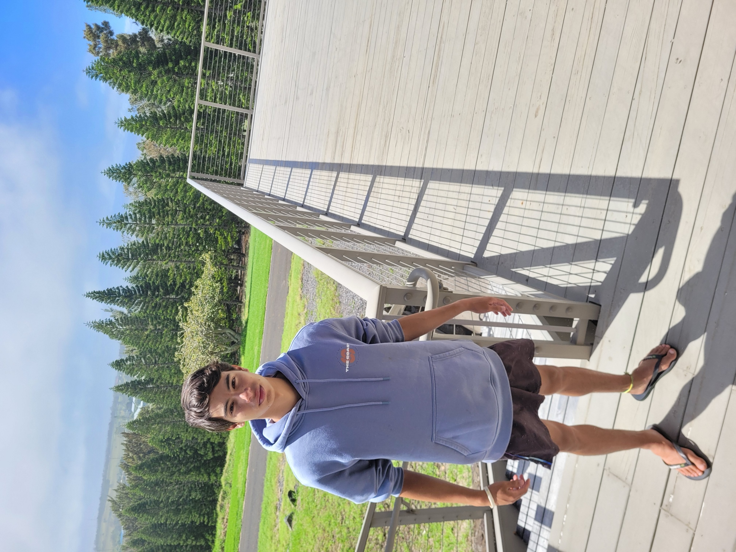1000032301.jpg---
Migrated from Apple Server Wiki. Original page ID: R8C4R8V9
# Where is Pedro?
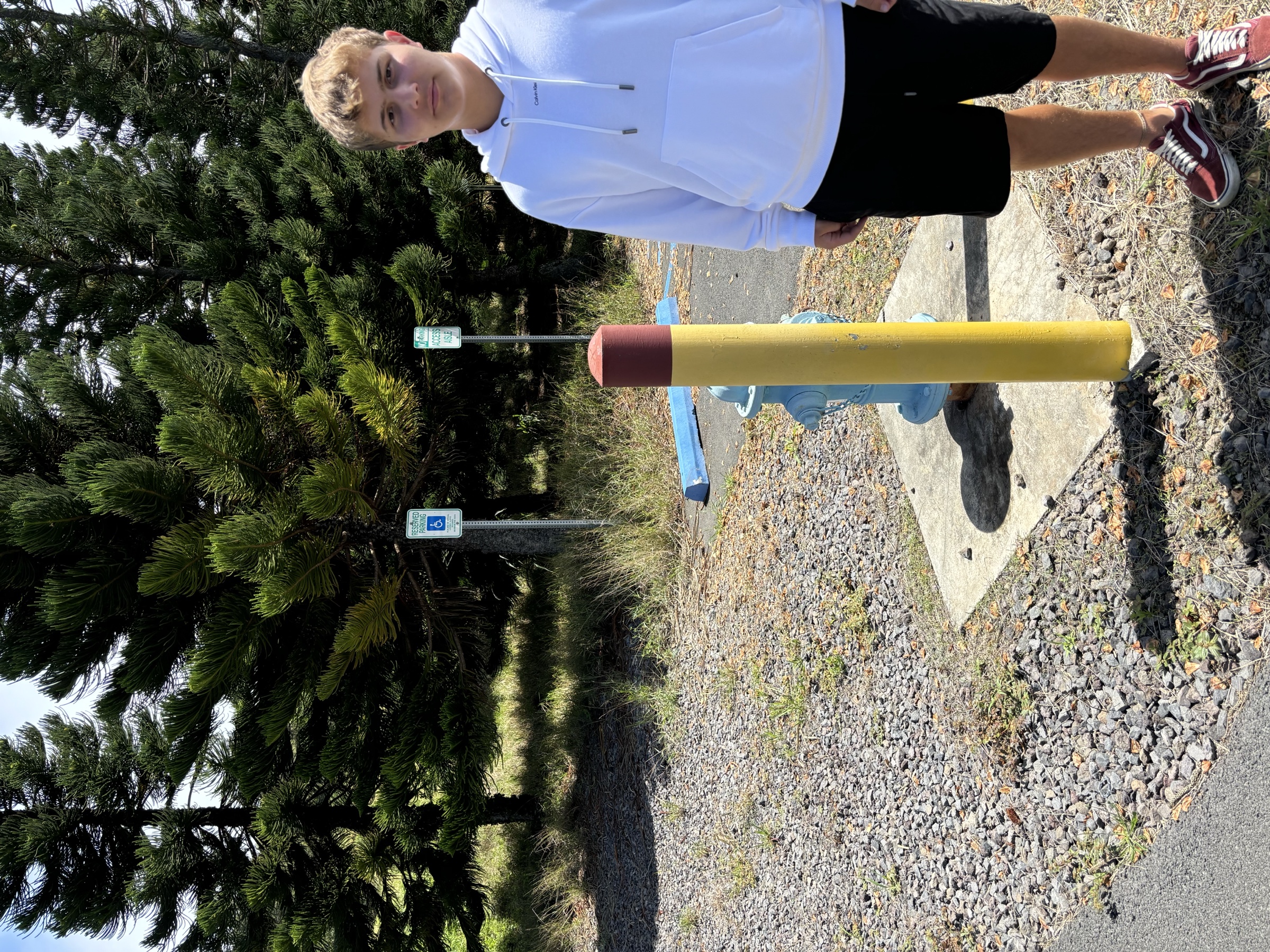IMG\_2030.jpeg---
Migrated from Apple Server Wiki. Original page ID: f438K3R2
# Lab 06c: navigation: find the evil villains!
International thieves have stolen a valuable artifact, and are demanding ransom, with their demands all arriving at noon today!
Your goal: using the shadow of the kidnappers (near the solstices of 9.21or 3.21) and any other information you can get from their ransom video-FIND THE THIEVES!
\----------------each of these videos arrived at the London headquarters of INTERPOL at noon (12:00 PM)
Clues:
1. From the angle of the shadow, calculate their latitude (at the equinox, this is their latitude, but be careful, this could be north or south)
2. From time clues in their videos, you can calculate their longitude (be careful: this could be east or west)
The Germans!
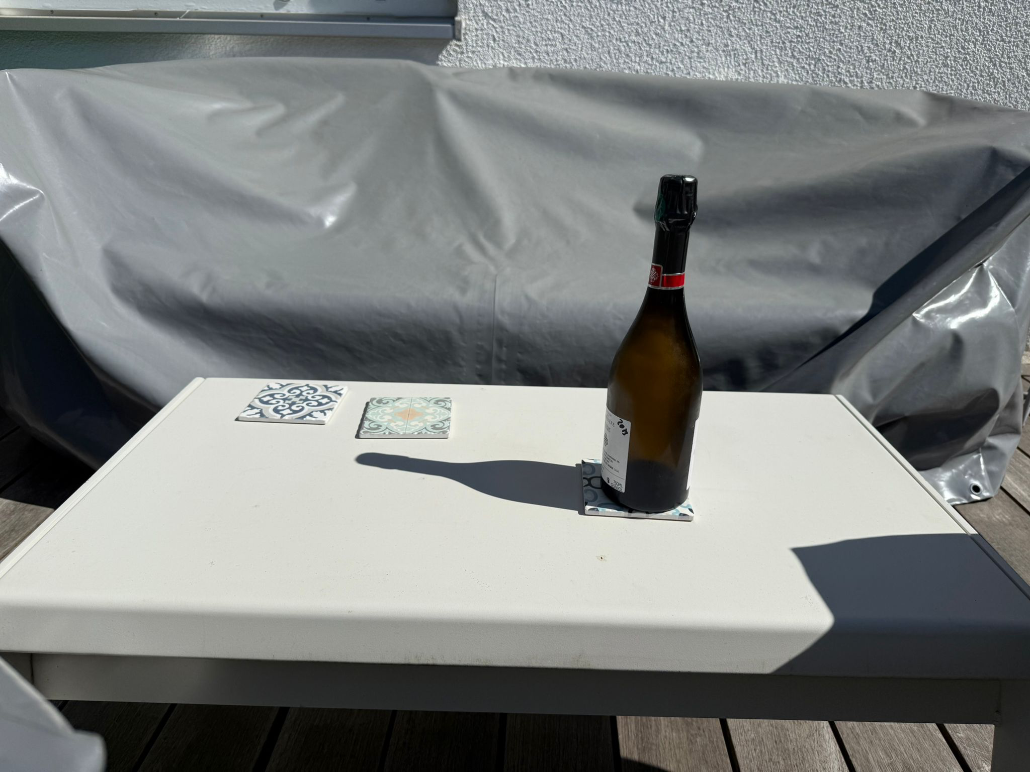image.png[Download BRD.mp4 (video/mp4, 19.7 MB)](https://bookstack.kamuela.org/attachments/20)Team Hawaii
IMG\_6477.jpeg[Download IMG\_4944.mp4 (video/mp4, 14.8 MB)](https://bookstack.kamuela.org/attachments/22)Team España:
[Download copy\_66FDD5F8-0510-40BD-A365-5A6E69F36AB5.MOV (video/quicktime, 31.5 MB)](https://bookstack.kamuela.org/attachments/23)Team Brasil:
[Download IMG\_3950.MOV (video/quicktime, 20.6 MB)](https://bookstack.kamuela.org/attachments/24)Goal: to locate each of us on a globe, based on the shadow where we are at noon (from a photo, see below) and the time in London (GMT time) at noon where we are.
Result: find each person based on latitude and longitude
Data:
Andre:
I am 45 west at 11 am
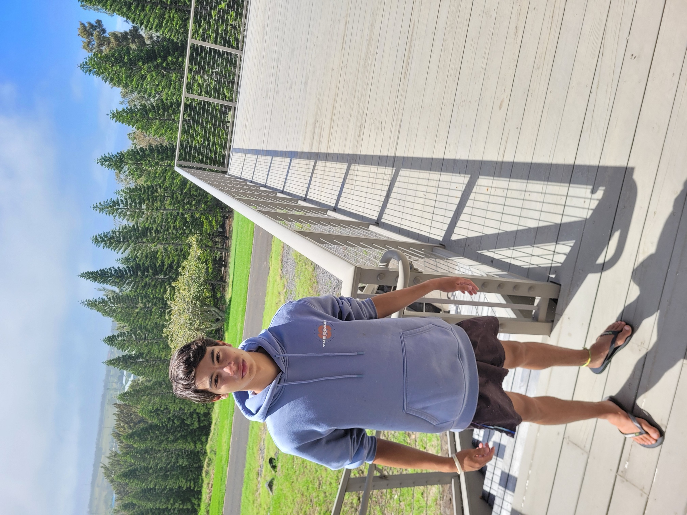andre.jpgLane:
The villainous terroristic Glorious Supreme Leader Lane Surdam of the Glorious Eastern Empire Republic has kidnapped Max and is asking the UN to disband and receive a ransom of 5,000,000, Lane is leading a revolution but cannot be found, he filmed this video on the 21st of September at 12 pm with his shadow at 5 degrees in Northern Hemisphere. You'll never find Glorious Supreme Leader Lane Surdam of the Glorious Eastern Empire Republic!!!!!
[Download Lane.mov (video/quicktime, 11.6 MB)](https://bookstack.kamuela.org/attachments/6)Max:
Max has turned supervillan!
He has kidnapped all of the microwaves from the dorms, and demands 1 billion dollars!
He sent a ransom video (by radio of course, so he could not be tracked) today at noon his time, dated 9.21
He had the radio on the background, which might give us a clue to his location, and there is a clear shadow behind him.
Here is the audio extracted from his ransom video, it might help us find Max:
It is well known that Max loves the BBC...
Use all of your navigational skills to find Max!
[Download max.mp4 (video/mp4, 2.0 MB)](https://bookstack.kamuela.org/attachments/4)[Download BBC 1800c.mov (video/quicktime, 259.7 KB)](https://bookstack.kamuela.org/attachments/5)Pedro:
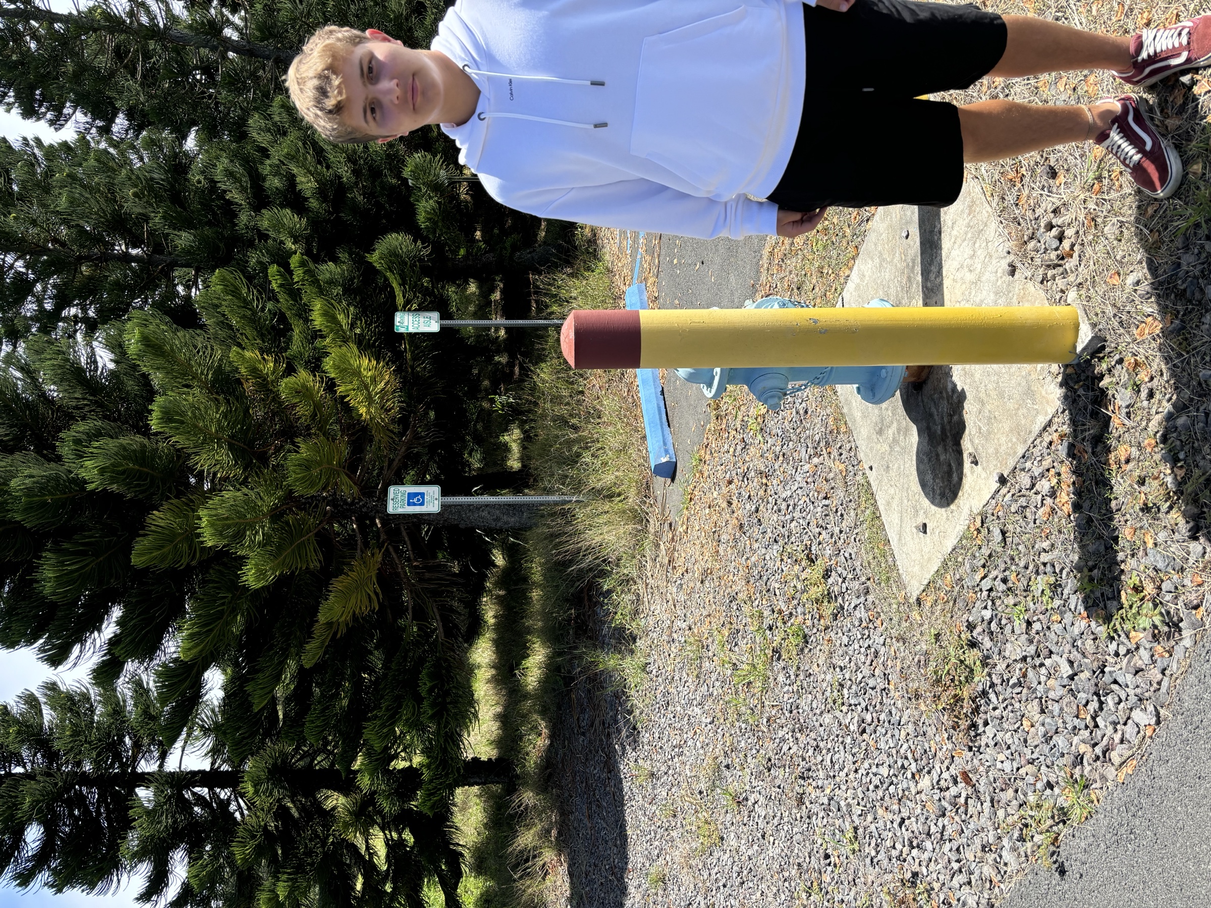pedro.jpg
Mel: 1200 GMT
---
Migrated from Apple Server Wiki. Original page ID: d429D3L
# Lab 05: navigation: tangents and mount Everest
Tangent method:
- measure a distance from the object (huge tape measure can be useful here)
- measure the degrees you see in your astrolabe to the top of the object
- use the tangent calculator on your phone: tan = opposite (height)/adjacent (distance)
- you could also use: distance x tangent θ = height
- make sure to add your eye height
- use this method to determine the altitude of the same objects
- try to calculate the altitude of Mauna Kea by looking up the distance, knowing the elab is at 800 meters altitude (confirm this with the GPS on your phone)
- using google earth, look up the distance between several peaks on your map and make a scale ruler for your map
- use this scale ruler to find the distance to other peaks
- repeat the tangent method to find the height of each peak you can see: Hokuula, La'e La'e, Mauna loa...
Questions:
1. who measured the height of mount Everest?
2. how did he/she do it?
3. why do you need to know the elevation of your observation?
4. if you measure Mauna Loa as 5 degrees and it is 60 km away, what altitude above sea level is Mauna Loa?
5. Look up the true altitude and calculate your error
---
Migrated from Apple Server Wiki. Original page ID: m0m6o3
# Lab 04: navigation: astrolabe 45-90
45 degree method:
- find your "eye height" by looking at a ruler on the wall, write this down
- set your astrolabe for 45°,
- walk towards the object (pole, building, tree) until it shows up in your sight
- measure the distance to the object
- add your eye height to this distance
- this is the height of the object (isosceles triangle)
- use this method to find the height of the elab, a flagpole, and several objects of your choice
Team challenge:
- each of your teams has measured several items on campus
- find the height of each one (one point each)
1. what sort of triangle are you creating?
2. why do you need to include your eye eight?
3. why is this not really useful for distant objects?
---
Migrated from Apple Server Wiki. Original page ID: r7d1T42
# Lab 03: navigation: astrolabe
[https://en.wikipedia.org/wiki/Celestial\_navigation](https://en.wikipedia.org/wiki/Celestial_navigation)
Main points:
An astrolabe is a device for measuring altitude of objects, or the angles of stars or planets for navigation. You can make your own using a protractor, a straw, some tape, dental floss and a rock or weight (see below):
[http://www.hmdt.org.uk/STEM\_lesson\_plans/2%20Physics/2%20Hypatia/3%20Make%20an%20Astrolabe%20Worksheet.pdf](http://www.hmdt.org.uk/STEM_lesson_plans/2%20Physics/2%20Hypatia/3%20Make%20an%20Astrolabe%20Worksheet.pdf)
[https://www.nps.gov/teachers/classrooms/make-your-own-astrolabe.htm](https://www.nps.gov/teachers/classrooms/make-your-own-astrolabe.htm)
Goal: construct your own astrolabe
Questions:
1. why is it important to have the string go through the center hole and hang freely?
2. how accurate is your protractor in measuring degrees?
3. would your astrolabe be more accurate if the straw were replaced by a telescope? How?
---
Migrated from Apple Server Wiki. Original page ID: F6J5D8e4
# Lab 06: navigation: globes and calculating latitude
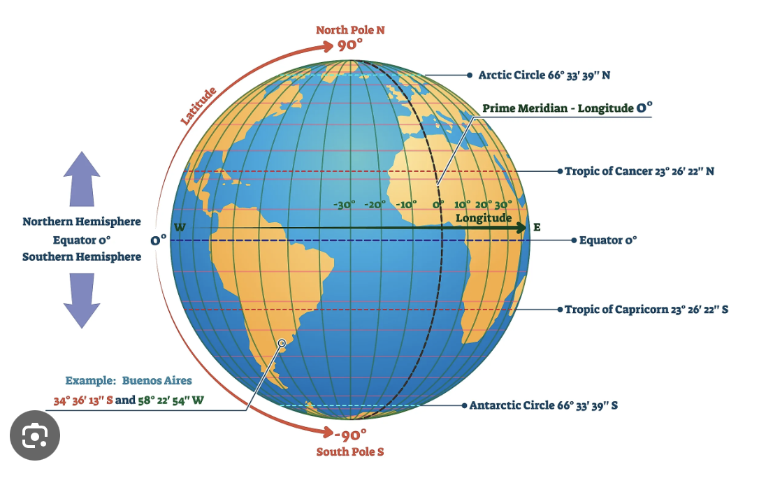
Globes 101:
Screenshot 2026-02-03 at 2.33.21 PM.png
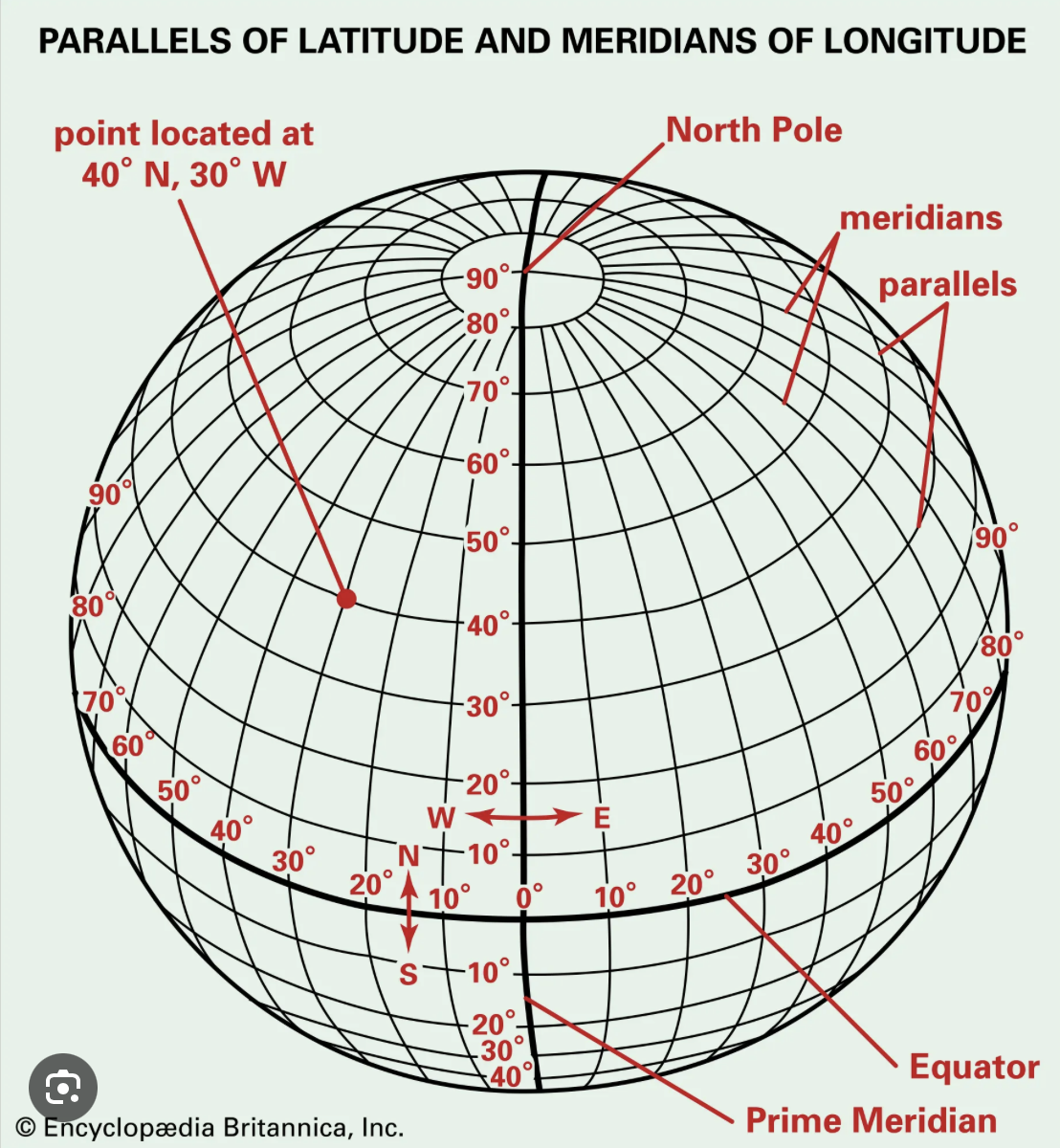
- start with the equator: named because it is an equal distance from each pole
- notice there is a 0° mark on the equator
- track north to see the degrees marked-these are latitudes (think of rungs on a ladder)
- do the same going south
- notice the tropics of Cancer and Capricorn, these are named for the star constellations that are at these angles in the sky
To navigate to a place on the globe, we need both latitude and longitude:
Screenshot 2026-02-03 at 2.33.04 PM.png
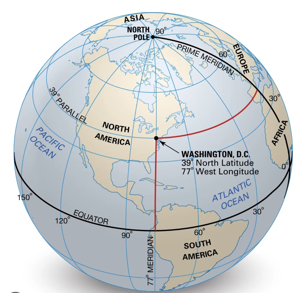
- Notice that 0° longitude is called the "prime meridian"
- This is no accident: the first telescope used to calibrate clocks to calculate longitudes while at sea was based outside London in a place called Greenwich (pronounced "gren-ich")
- This is why you might see times while traveling or calculating a phone or zoom call as GMT, this is Greenwich Mean Time, also known as UTC, or Coordinated Universal Time.
- In the diagram below, Washington DC is at 39° North Latitude or 39°N and 77° West Longitude (sometimes called 77°W
Screenshot 2026-02-03 at 2.32.47 PM.png
- Find the longitude and latitude of six places of your choice and quiz your classmates. Make sure to include several in both north and south hemispheres, east and west of the GMT line.
You can find people on the globe if you know both of these, even evil kidnappers like in the next lab...
Globe 102: Orbits and seasons
First you have to understand the seasons...
- map out the orbit of the earth around the sun on your big piece of paper (we know it is not a circle, ok for now), using a loop of dental floss
- label out the seasons on your paper, including the tilt angle of the earth at each transition, March 21, June 21, September 21, December 21, with June 21 at the top of your paper
- at the equinoxes ("equal night") determine the tilt of the earth everywhere on the planet
- what would the angle of a shadow look like in Waimea at noon on this date?
- compare with Alaska, Spain, Brazil, Germany and a few others that you pick
- Look these up here: [https://www.sunearthtools.com/dp/tools/pos\_sun.php?lang=pt](https://www.sunearthtools.com/dp/tools/pos_sun.php?lang=pt)
- repeat this at the solstices for these locations-what do you notice?
- if we lived on the tropic of cancer (north) or tropic of capricorn (south) what would the sun angle be on the solstices?
- what about on the equinoxes?
- why are they named this way? (look this up)
- what would be the lowest angle the noon sun should be in Waimea, and on what date?
- what would be the highest angle the sun should be at noon in Waimea, and on what date?
- what are the longest and shortest days where you are from?
Ok, now that we know the extremes, imagine we are in between one of these extremes:
- mark where we would be on your season map based on the date
- what degree should ours be between?
- measure the angle of the sun at around noon (noon is best, but close will be ok for now)
- using your angle, look up on a navigation almanac online what our latitude should be
- how close are you?
Questions:
1. If you lived where the shadow of the sun was 22.5° at solar noon, on 9.21, where could you possibly be?
2. What would your angle be on 12.21?
3. What would your angle be on 6.21?
4. What other date would have the same angle as #1?
5. Calculate the noon solar angle for your home on 3.21
---
Migrated from Apple Server Wiki. Original page ID: C6S3f6
# Lab 06b: navigation: calculate longitude
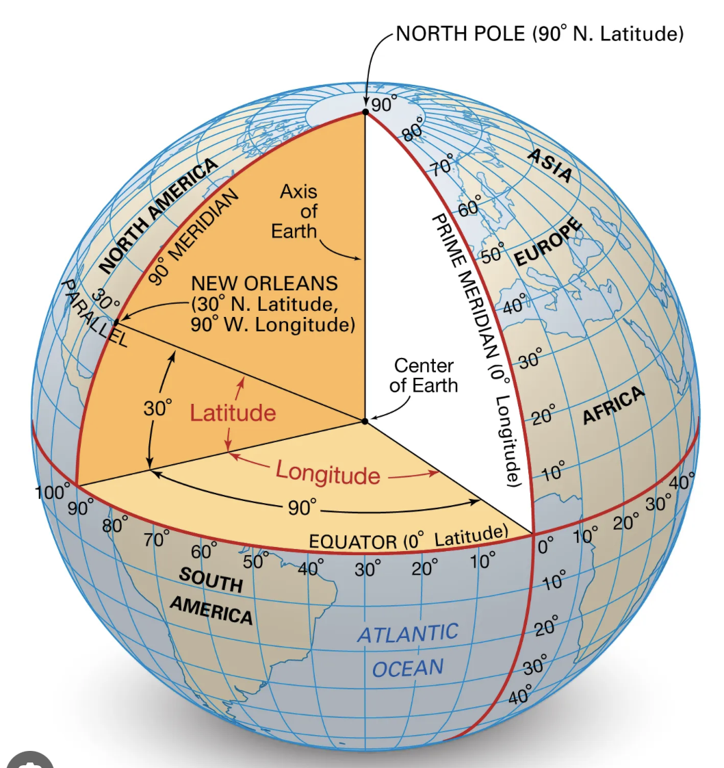
Calculating longitude ("long lines")
Screenshot 2026-02-03 at 2.52.47 PM.png
First we have to understand a bit about astronomy, and why there is a famous telescope at a place called Greenwich near London...
- on a globe, find London
- notice the longitude of London
- find the longitude of where you are from and record this
- if every 15° of latitude is one hour, calculate how many degrees away from London your home is exactly
- the telescope at Greenwich near London calculated noon exactly. If you had a clock with you, wherever you were on the planet, if you knew what time "local noon" was, you could calculate your latitude.
- Local noon was found at sea by tracking the sun as it rose, and noting the time it was the highest, "local noon"
- Interestingly, dawn in Waimea is a bit earlier than dawn on Oahu, you can check this by talking to someone in the morning there, or even more fun, time our sunset with theirs-who will be later?
- there are a set of radio stations around the world that now broadcast this time signal on the radio, so ships and lost students can determine their latitude if they know local noon.
- on a radio, listen for WWV or WWVH (Hawaii version) on 10 MHz shortwave here: [https://wwv.mcodes.org/](https://wwv.mcodes.org/)
- notice that when the chirps make a long beep, your phone, your computer and any device changes the minute-EXACTLY
- notice that the time on the radio or online is UTC, so everyone on the planet can use it
- why do you care? if your computer or phone is on the wrong time even by a few minutes your web browser, email and everything on the internet will not work-why?
- Since our class does not meet at exactly noon, you can look up local noon on the web for this location
- calculate our longitude from this number
- since you can look on your super-fancy big island map, label our latitude and longitude if you have not already
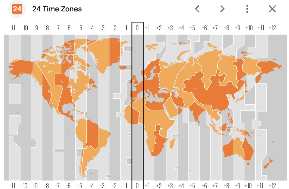
- how many hours and minutes should we be from GMT (Greenwich Mean Time)?
- China has one time zone-how does this impact life there?
- Look at these time zones-we are always at -10h
Screenshot 2026-02-03 at 2.49.19 PM.png
Putting it all together:
You now know how to find your latitude using an astrolabe, and your longitude using an astrolabe and a good clock
Look up how to do this with your hands if you are lost in the wilderness or at sea...
Questions:
1. Why would having a really accurate clock aboard a shop enable you to navigate better?
2. China has one time zone for the entire country-how does this impact life there?
3. We are at 155°W, so is our solar noon earlier or later than GMT? Explain
---
Migrated from Apple Server Wiki. Original page ID: \_6i0i388\_
# Lab 09: earth: igneous rocks
Believe it or not, you are standing on igneous rock (unless you are standing on a coral head, which is illegal).
The Big island is one huge igneous rock, so pick up a piece and melt it with the sun.
MAKE SURE YOU USE THE DARTH VADER HELMET OR GREEN GLASSES
Your goal is to focus the sun's rays on a small spot using a large fresnel lens (like a normal lens in a camera, but made of grooves in a plastic sheet) and determine the melting point of igneous rocks on our island.
Cooking cookies with sunlight:
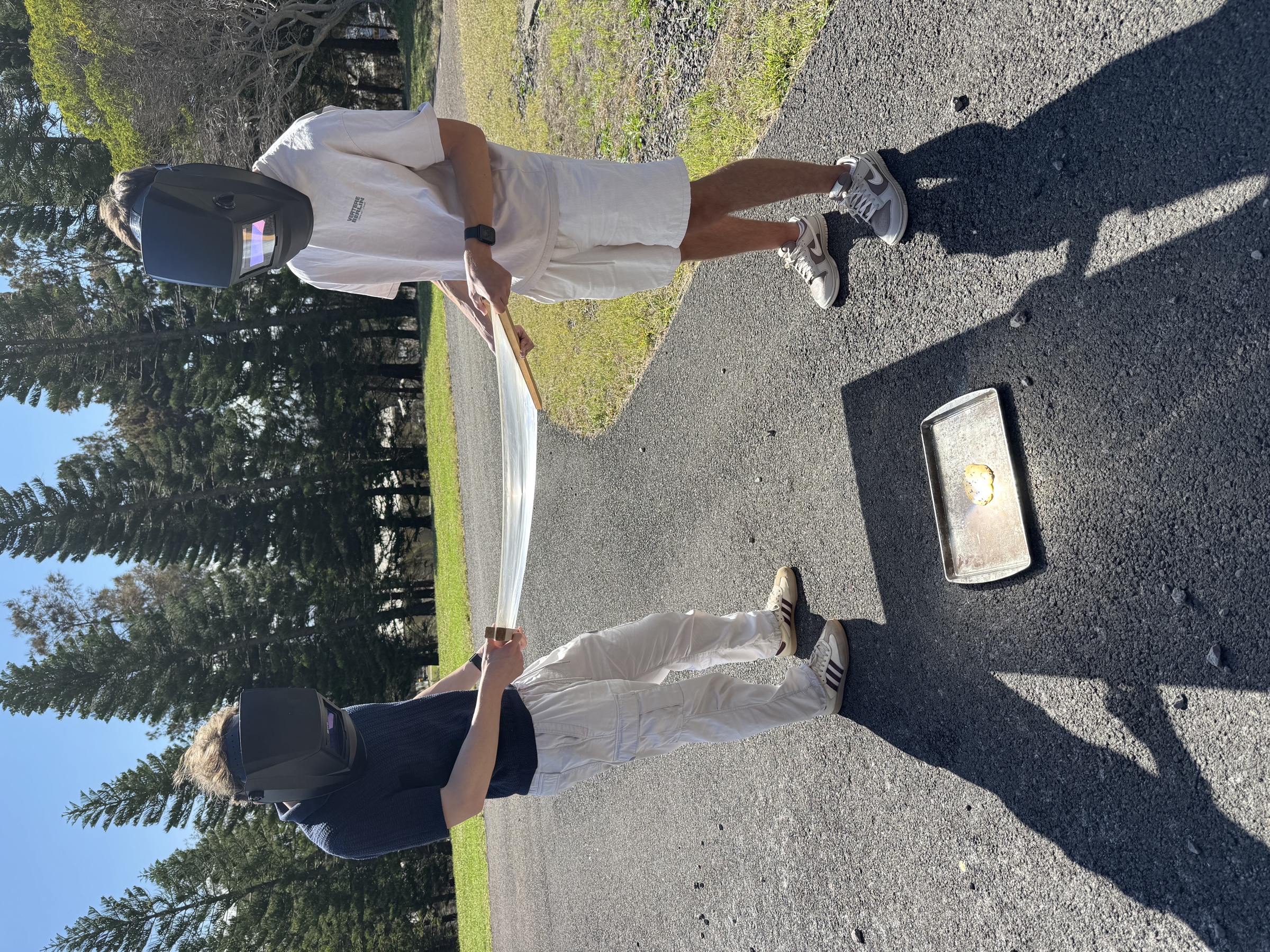IMG\_1965.jpegSteps:
1. find a darth vader welding helmet: some have fixed dark glass, others are "clear" until you see something bright like the sun.
2. test your helmet by looking at the sun-if it is a cloudy day, you might be able to ignite wood, but you will need a clear full-sun day to melt igneous rocks to magma
3. get the large plastic sheet that focuses sunlight-be careful handling it, and don't allow the focus to burn your feet or clothes
4. start by holding the lens perpendicular to the sun-you will need two people working together to make this possible
5. raise and lower the lens until you see a small bright dot on the ground
6. put a piece of wood where you see the dot, and try to ignite it, measuring the temperature with the scanning thermometer
7. repeat with burning the asphalt of the road (you will not be the first to do this), measure the temperature
8. repeat with an aluminum can, measure the temperature
9. If it is a full sun day, patiently aim at a piece of rock from around the elab-DO NOT use concrete or coral, concrete can explode if heated, coral is just nasty
10. continue until you can see the rock bubbling (it will turn red first) and measure the temperature
11. we have two types of cooled magma: a'a and pahoehoe-which did you create?
12. what is the difference between each of these, and why?
---
Migrated from Apple Server Wiki. Original page ID: 67L6p8A
# Lab 11: earth: mapping earthquakes
Part 1: Shakenet
On your humongous map of the big island, we will be calculating the epicenter of earthquakes.
Here is an example of an earthquake measured by our seismic sensors (seismographs):
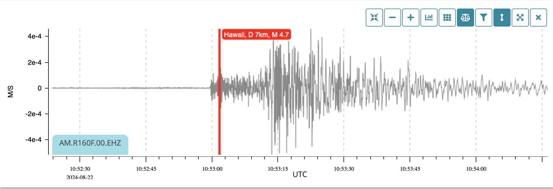quake.pngTerms:
- epicenter: the place on the surface above the quake
- hypocenter: the actual place under the surface where the quake occurred
- P wave: primary wave, a compression wave that travels fast, and can go through liquids (more on this soon)
- S wave: secondary (slower) wave, a transverse wave that cannot go through liquids
- Delay: for every second between P and S waves, you are 8 km from the quake
- You will also get to see a real-live quake sensor being built by Nick Winterowd from our ISR class
- Look at the stations, and pick one on our island
- On the right, you can select 24 hour view
- Look for a quake that happened recently
- Notice how spaced the front (P wave) and second part (S wave) are.
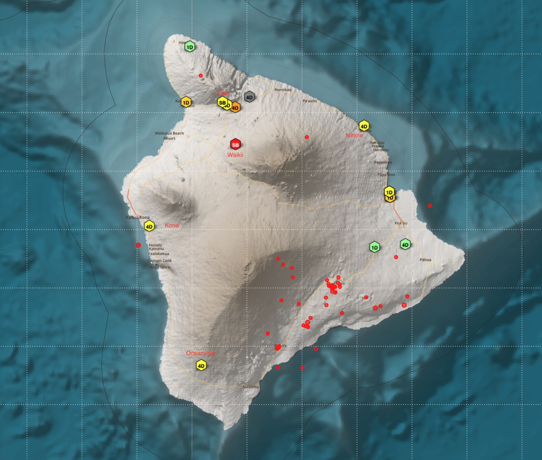
- Notice how far each station is from the red dot on the map that represents each quake.
- Calculate the distance from each station and draw a circle around it on your big big island map
- Determine the epicenter and hypocenter
Questions:
1. why would the gap in Hilo be smaller than the one at HPA?
2. look up why it is important to know that only P waves travel through liquids
3. how did the seismic network on the planet show us what the core of the earth is made of?
4. who constructed this network and why?
5. what is the Richter scale, and how much stronger is a 5.0 than a 4.0 quake?
6. below is a report on a quake in Japan. Why are his numbers different from the normal velocities?
Screenshot 2025-09-17 at 12.43.28 PM.png
Your seismic stations are at the following locations:
Oceanview 4D
Kona 4D
Waikii SB
Ninole 4D
Elab SB
You will locate 4 actual earthquakes, some of them very large (7.0)
Each station records a P wave followed a few seconds later by an S wave
Knowing that for every second the S wave is slower than the P wave, the quake is 8 km away
Find the location of each quake on your huge map
Clues:
One of these caused a power outage all over the state, another began a huge lava flow, another was on a supposedly dormant volcano, and another may be erupting today...
Stage a quake somewhere on the island or offshore, and calculate the number of seconds separating the P and S waves.
Challenge your classmates to locate the quake with your name on it!
Local Quake!
1. go here: [https://stationview.raspberryshake.org/#/?lat=19.60360&lon=204.04469&zoom=9.442&sta=R277A](https://stationview.raspberryshake.org/#/?lat=19.60360&lon=204.04469&zoom=9.442&sta=R277A)
2. find the stations on your map
3. click on each of the stations, find the quake that happened at 2:33 AM in the morning, 24.9.25
4. click the + key and measure the seconds between P and S waves:
5. 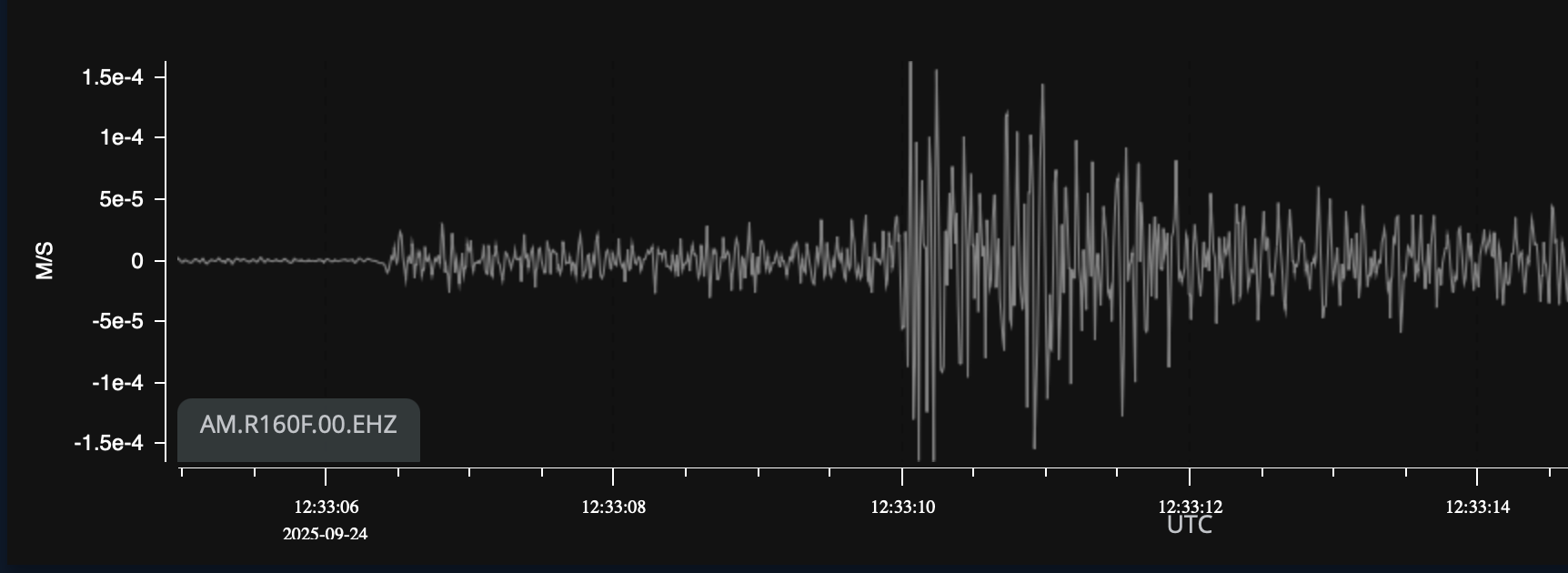elab.png
6. use your awesome mapping skills to find the epicenter of the quake!
### January 26,2026 quake 4.2 Pahala, depth 33 km
Surface distances:
- Ninole 87 km
- Kona 64 km
- Waikii 75 km
- Volcano 51 km
- Kawaihae 96 km
- elab 92 km
1. Pahala 4.2 quake 23:32 1.26.26
2. calculate speed from P-S interval, google earth
1. go to [https://elab.hpa.edu/wiki/pages/A1F512W/Lab\_10\_earth\_earthquakes.html](http://10.14.4.85:6875/books/island-science-migration-test/page/lab-11-earth-mapping-earthquakes) review
2. go to [https://stationview.raspberryshake.org/#/?lat=19.67729&lon=204.30904&zoom=9.019](https://stationview.raspberryshake.org/#/?lat=19.67729&lon=204.30904&zoom=9.019)
3. look at “map filters”, choose last two days
4. find a new quake to study
5. go to each station, find the same quake
6. measure P-S interval
7. google earth: measure distance in km to quake or use shakenet
8. calculate seconds per km
9. average your super accurate results
10. use to locate the quakes on the elab page above
---
Migrated from Apple Server Wiki. Original page ID: A1F512W
# Lab 01: navigation: compass challenge
Part one:
1. trace out a map of the big island
2. using your phone in compass mode, take a sighting of at least three peaks you can identify on your huge map.
3. triangulate from there to your location
Part two:
1. pick a place on your map that you need to be rescued from
2. you have 1 minute of cel battery left, and your gps is not working
3. calculate the angles you would see from this point to each of the major peaks on the island
4. post your numbers on the whiteboard (or below) for the class to locate you
---
Migrated from Apple Server Wiki. Original page ID: U7x9h9U4B6
# Lab 14a: earth: ahupua'a model
[https://en.wikipedia.org/wiki/Ahupua%CA%BBa](https://en.wikipedia.org/wiki/Ahupua%CA%BBa)
On your huge big big island map, diagram the Ahupua'a between Waimea and Kona, including the Pelekane watershed.
Make sure to label each one clearly
Ask a friend from Kona to take photos of the Ahupua'a markers along Queen Kaahumanu Highway on the way to Waimea
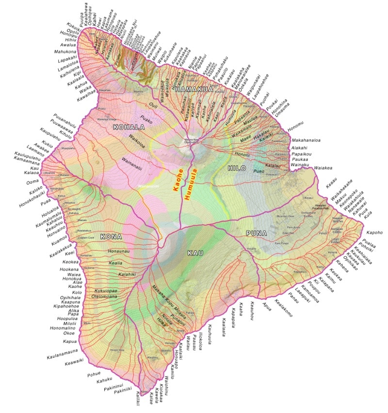Hawaii-Island-Ahupuaa.jpgQuestions: email for credit
1. how does your work on biomes connect with the ahupua'a model?
2. what is the difference between a watershed and an ahupua'a?
3. why was this model so successful in maintaining a sustainable culture?
4. what was the biggest ahupua'a on the island, and why?
5. how did the great mahele impact this model? good or bad?
6. how many markers can you see when you drive along the coast from Kona to Waimea?
7. how has resort development impacted this system?
8. what is the coast path known as in Hawaiian, and what was its function?
9. what is the story of the city of refuge, and how did this promote social structure?
10. why are there more on the Hamakua coast than on the Kona coast?
---
Migrated from Apple Server Wiki. Original page ID: m093f9K
# Lab 10: earth: volcanoes: magma, gases and spectra
[Simulator](https://elab.hpa.edu/isci/sims/volcano.html?target=)
Detecting the gas composition of a volcano is important in predicting impending eruption.
There are two types of magma, based on chemical composition:
- Basalt is runny, less-viscous magma that flows freely and creates the volcanoes we have in Hawaii
- Andesitic is sticky, more viscous and forms the cone shaped volcanoes in the Andes (hence the name), Japan, Indonesia, Mexico, and Italy.
Magma is under the surface, Lava is once it reaches the surface, both are classed as igneous rock.
Once magma reaches the surface, it becomes lava, and can then solidify into several forms:
a'a is the Hawaiian name for rock that cools very quickly, while gases are still bubbling from the lava
pahoehoe is the ropey rock that is formed when lave cools more slowly
obsidian is the glass like rock formed if the lave cools very slowly
Pumice is a version of a'a
Pele's hair is magma that solidifies in the air, making strands of rock
Vog is small particles of pumice with sulfuric acid in the small spaces-very irritating
Part 1: Magma temperature
1. Using the massive lenses we have in the lab below, and using the Darth Vader helmets or goggles for protection, focus the sunlight on any rock you find on this island (why not coral or concrete?)
2. Using the infrared temp sensor, measure the temperature of the magma
Part 2: Volcanic gases
1. Go to the purple air website and look up the air quality around our island (over 50 is bad)
2. Investigate the different settings for types of volcanic gases
3. Go to weather.hawaii.edu and search for the vog cloud map
4. When would our air quality be poor and why?
5. Challenge: pick a place on the planet that has the worst air you can find: put the numbers on the board for the class to find them
Part 3: Spectra of gases
Using a spectroscope, look at several chemical vapors such as sodium, potassium and other flame test colors
These indicate what element is present, and can be used to measure relative amounts
Questions:
1. how is gas composition related to the depth of the magma?
2. what sort of rock would be formed from magma cooling underwater?
3. why would andesitic volcanoes explode while basaltic ones do not?
4. which type is vesuvius and what happened there?
5. why do volcanologists concentrate so much on expelled gases? is it a practical or scientific reason?
---
Migrated from Apple Server Wiki. Original page ID: S9E8H4
# Lab 13: earth: biomes map
1. Go to geoguesser: [https://www.geoguessr.com/referral-program/JDC3-E1LM-EDS1?s=pl](https://www.geoguessr.com/referral-program/JDC3-E1LM-EDS1?s=pl)
2. Or openguessr here: [https://openguessr.com/](https://openguessr.com/)
3. Start with your home, see how close you can get
4. Next go global: what tricks or clues do you find?
5. Finally, focus on Hawaii, the island you live on today, see what clues there are for you
6. What clues did you use in each case?
Biome mapping:
- Biomes are defined by temperature and water, with some variations with altitude, which impacts both, as well as distance from the ocean (why?).
- Fortunately we live on an island with many of the defined biomes used to define ecosystems around the planet.
Your challenges: 1 Biome map of Hawaii Island:
1. Map out the biomes we have on our island on your huge big island map, with some detail about each (min-max temp, annual rainfall).
2. at the bottom of your map, include your home location, with a description of the biome there (Brazil, Spain, Germany, Mars, etc.)
2 Your kingdom map
As the ruler of your own island, you know a great deal about it. On a large paper, sketch out what your home island looks like. It must include the following:
1. at least one volcano
2. at least three valleys next to each other, with ridges on each side and a stream running through the middle
3. a coral reef where each river meets the ocean
4. some form of vegetation: trees, vines, grass, etc.
5. some form of animals for food (be creative, but no cannibals please) Joke: why don't cannibals eat clowns? They taste funny...
6. a description of the weather and biome there
7. three ahupua'a, one on each side of the main river
3 Questions: email your answers for credit
1. what sort of animals (fauna) and plants (flora) would you expect to find in each biome on our island?
2. biomes are like your friends: it is not so much what they will do, it is what they won't do-how are these similar?
3. why is the big island able to host so many different biomes, and compare it to another place on the planet of similar size
4. how does a marine environment impact the biomes?
5. include a photo from google earth of your home location and what biome is there
---
Migrated from Apple Server Wiki. Original page ID: d1X2W7A8T5
# Lab 23a: ocean: tsunamis and waves
Tsunami is a Japanese word: from [Japanese](https://en.wikipedia.org/wiki/Japanese_language "Japanese language"): 津波, [lit.](https://en.wikipedia.org/wiki/Literal_translation "Literal translation") 'harbor wave'
[https://en.wikipedia.org/wiki/Tsunami](https://en.wikipedia.org/wiki/Tsunami)
Please read the wikipedia description for tsunami and then read below:
Waves can be transverse (movement sideways, perpendicular to the direction of motion) or longitudinal (along the same direction as the wave travel).
Part 1: Mapping tsunamis1.1 Pacific Tsunamis
1. Create a huge map of the pacific "ring of fire"
2. Map out the active volcanoes on your map
3. Map out the severe earthquakes in the past 150 years on your map
4. Calculate the P-S time difference for each one
5. Look up the velocity of tsunami waves in the open ocean and calculate how much warning time we would have for each
6. Going back to the three major tsunamis on our island since 1946, calculate how much warning time we had for each
7. Why were so many people killed in Hilo during the 1946 tsunami?
8. Look up the tsunami simulation for a slide off of Mauna Loa
9. Look up the speeds here: [https://www.noaa.gov/jetstream/tsunamis/tsunami-propagation](https://www.noaa.gov/jetstream/tsunamis/tsunami-propagation)
1.2 Physical oceanography
1. look up the Bali earthquake of 2004
2. what caused this?
3. look up the Puako earthquake of 2006 (called the Kiholo Bay quake)
4. how are these similar? different?
5. Do the same for the Japan tsunami: Fukushima Daiichi
6. if a quake causes plates to slide past each other, with no water displacement, should this cause a tsunami?
7. what does cause tsunami?
8. email your answers
1.3 Plate tectonics
1. On your ocean map, draw our island chain, starting with our island and moving NorthWest
2. Continue mapping the islands to those atolls and submerged islands
3. Are these in a straight line? Why?
4. The pacific plate is subducting under another plate-where does this happen?
5. Mark this subduction on your map (look at the map online for symbols)
6. Where else do you see this?
7. Look at the ocean where the plates go under-what is always there?
8. What sort of volcanoes are formed after this?
Part 2: Tsunami Waves
Tsunami as waves
1. Test out each of these types of waves using a long spring on the floor.
2. send a pulse from one person to the other end, and notice which side the pulse returns on
3. this is known as a hard reflection
4. repeat with a string holding the other end, what do you notice?
5. this is a soft reflection, notice the side the pulse returns on
6. repeat pulses to create a single wave between you and the other end
7. measure the frequency for your wave (count ten pulses, time, divide by ten)
8. measure the wavelength between you and the other end
9. if velocity = frequency \* wavelength, calculate the velocity for your wave AT THIS TENSION
10. record a video of this experiment and email it to Dr Bill
Tsunami period
1. Look up the velocity of tsunami waves
2. are they transverse of longitudinal?
3. what is their velocity?
4. what is their wavelength?
5. what is their frequency?
6. 1/frequency is period, what is the period of a normal tsunami wave?
7. who cares? why do so many people drown in a tsunami by running out to capture fish?
8. you are sitting at the beach, and the water suddenly recedes. what do you do, and how long do you have to do it? (please don't say "I go out and get fish")
9. compare the wavelength, frequency and velocity to sound waves-why?
10. email your answers to Dr. Bill
Tsunami amplitude
1. how big above the surface is a tsunami in deep water?
2. where is the energy in a tsunami wave in deep water?
3. if a tsunami is huge in the harbor, why?
4. what happens to the velocity of a wave as it enters shallow water (surfers know this)
5. why is this relevant?
6. email your answers to Dr. Bill
Part 3: Sound waves
Sound waves
1. using a closed tube, find the frequency that resonates with the tube using a sound generator
2. measure the length of the tube and multiply by 4, this is the wavelength
3. calculate the speed of sound in the elab at that moment (changes with weather)
4. measure the distance in meters between the walls of the bathroom stall of your choice
5. this is the wavelength we will use: a multiple or fraction of this-you find out
6. using the speed of sound from above, calculate the frequency that will resonate in the bathroom stall
7. using a sound generator, find this frequency
8. why do singers find the acoustics of bathrooms so nice?
9. Look in GPAC at the sound reflectors above the stage-why are they shaped this way?
10. Look up refraction and look into why waves might change direction in the ocean
11. Look up Rogue waves and explain how superposition is part of this
12. How would you demonstrate rogue waves with the long spring?
13. record a video of your experiment and email to Dr. Bill
Challenges:
1. Make a video of a slinky, demonstrating P and S waves
2. Make a video of a longer spring, demonstrating hard and soft reflections
3. Make a video of a longer spring in a single standing wave-calculate velocity, wavelength and frequency
4. Make a video of a resonant sound tube, and calculate the speed of sound in the elab that day (see above)
5. Make a video of another resonant situation somewhere in the elab (bathroom, monlab speakers, etc.)
---
Migrated from Apple Server Wiki. Original page ID: U281V4g
# Lab 23b: ocean: oceanography
Sections:
- Bathymetry
- Loihi
- Island chain evolution
- Layers
- Currents
- Salinity
- Temperature
- Pressure
Part one: sonar and whales
1. look up the speed of sound in air, water and earth
2. look up the frequency of bat ultrasonic chirps (air), sonar (water), dolphin chirps (water), and whale song (water)
3. calculate the wavelength for each
4. why do bats need such small wavelengths? what do they eat?
5. are whales using sound as navigation or just conversation, or both?
6. what about dolphins?
7. how do ships find how deep water is below them?
8. look up SOFER channels, how do submarines use these?
Part two: bathymetry (measuring the ocean floor)
1. look on google earth for the surface of the ocean
2. find the deepest parts and look up how deep these are
3. how long would a sound pulse take from the surface to the bottom and back? (you need to look up the speed of sound in sea water)
4. look on the map north east of the island of Oahu-what do you see on the ocean floor?
5. look up the Nuuanu Slide on wikipedia-when did it happen?
6. look up how basaltic volcanoes (like ours) create "rift zones", then "calve" off
7. what happened in the Nuuanu slide?
8. how big was the tsunami?
9. how do we know? (clue: Mt. Kaala is on the west side of Oahu, it is 4055 ft. high)
10. watch the simulation of the Mauna Loa tsunami online-how would we be impacted? what about folks on Oahu?
11. watch the video of the Bali tsunami and the Fukushima tsunami-how are these different?
12. what kills most folks in a tsunami?
13. why is there a huge breakwater across Hilo harbor?
14. what are the biggest tsunami to hit our island and when?
15. what caused them?
Part three: Loihi
1. look for the subsea volcano named Loihi
2. where is it?
3. see if you can find video of the deep sea submarine taking video of the volcano
4. what volcano is closest to it?
5. look up the ages of the 5 volcanoes on the Big Island of Hawai'i
6. which is the oldest? youngest?
7. where would the next oldest one be? (hint: look at the undersea map off the coast of Mahukona)
8. look up the age of Kauai-how does this compare?
Part four: island chain evolution
1. look up the age of Kilauea
2. look up the age of Waialeale on Kauai
3. on the undersea map, what is the next oldest and where?
4. follow this chain along the ocean floor-where does it end?
5. how did this happen?
6. what is a hotspot, and why do you care?
7. make a map of the island chain from oldest to newest, including the age of each main volcano (find a nice map online and print it on the color printer)
Part five: NADW
1. look up the north Atlantic deep water (NADW)
2. where does it start?
3. what is it made of?
4. how old is the water in the NADW?
5. where does it surface?
6. look up the Koyo water company in Kona
7. what do they sell and to whom?
8. for how much per liter?
9. why would people pay for this?
10. come up with a business plan to sell your own "NADW water": what would you sell, and to whom?
Part six: temperatures
1. look up the temperature of water at the bottom of the Marianas Trench
2. how deep is this?
3. why is it so cold?
4. look at a map of the surface sea temperatures
5. where is it hottest?
6. look off the west coast of Africa, and Mexico-why should you care?
7. how do they use the cold water from the coast of Kona at NELHA?
8. how deep is the pipe that feeds NELHA?
9. how would you use it?
10. how is it used to irrigate strawberries?
Part seven: Marine biology
1. listen to this audio: [https://www.bbc.co.uk/sounds/play/m00237zl](https://www.bbc.co.uk/sounds/play/m00237zl)
2. do you think dolphins and whales have a vocabulary?
3. how is this different from how they navigate?
4. look up the "melon" in dolphins and whales-how does it work?
5. why is this better than using air?
---
Migrated from Apple Server Wiki. Original page ID: 69W9m1
# Lab 17a: sky: layers, climate change
Sections:
- Layers
- Temperature
- Density
- Composition
- Ionosphere-radio reflection
- Muons
- Troposphere-weather
- Stratosphere-flight
- Ozone layer
- Climate change
Part one: layers (onion boy)
1. look up the layers of the atmosphere
2. where is weather located?
3. where do planes fly to the mainland?
4. why does it get colder as you go up at first?
5. what are airplane contrails made of? why?
6. why does the thermosphere get hot?
7. why is it also called the ionosphere?
8. why is this important for satellites and radio waves?
9. locate the ozone layer-what gas is there?
10. what does it protect us from?
11. why is that important?
12. look up the "ozone hole"-where is it?
13. what happened to it?
14. what about now?
15. make a huge labeled diagram of our atmosphere to scale, both at night and daytime
16. check out this video around 1:18 for a look at what the atmosphere looks like when you re-enter from space: [https://www.spacex.com/launches/mission/?missionId=starship-flight-5](https://www.spacex.com/launches/mission/?missionId=starship-flight-5)
Part two: climate change
1. look up the term "greenhouse gas"
2. why is it called that?
3. what on a greenhouse is like the gases?
4. which ones are the most potent?
5. which ones last the longest?
6. what would the temperature of the planet be with NO greenhouse gases?
7. what do plants do with carbon dioxide and oxygen in the daytime?
8. if they die, and millions of years later, we burn them as fossil fuels, what do they release?
9. why has the temperature of our planet increases like crazy since about 1850?
10. what happened then?
11. how will this impact the level of the sea?
12. how will this impact glaciers?
13. look up the "doomsday glacier"-how big is it, and where?
14. what would happen if this melted?
15. the year is 2100, you are about 90 years old, what does the beach around our island look like?
16. draw an island map of the shore now and when you are 90
---
Migrated from Apple Server Wiki. Original page ID: p366w2p
# Lab 22: sky: space weather
Who cares?
- Ionosphere
- Solar radiation
- Solar cycles
- Day/night variations
- Reflection of radio waves: wavelength
Challenges:
1. Look up the ionosphere: where is it?
2. What is it made of?
3. Why does it change from day to night?
4. How can people on the mainland hear radio stations far away only at night?
5. How is it important to radio waves?
6. Look up 40meter.net and look at the line across the graph: what does this mean?
7. How could this impact your internet speed?
8. Why do the starlink folks care about this?
9. What is a solar flare and how does this impact the ionosphere?
---
Migrated from Apple Server Wiki. Original page ID: X9M6k3J
# Lab 18: sky: weather, air quality
Sections:
- Solar radiation-drives everything
- Radiation, conduction, convection
- Movement of air=weather
- Temperature and humidity
- Cloud formation
- Storm formation: hurricanes and tornadoes
- Climate change
- Ozone depletion
Part one: purple air
1. look up purpleair.com
2. find the cleanest air on the planet, and the dirtiest
3. why?
4. is it always human caused, or can it be more natural?
5. what is the air quality measuring?
Part two: radiation, conduction and convection
1. what is the hottest part of the globe?
2. why?
3. if energy moves in three ways: radiation, conduction and convection, when hot air rises, which is this?
4. how about when air touches warm ground?
5. when sunlight goes through the atmosphere and reaches the surface?
6. if warm air rises, what comes in its place?
7. from where?
Part three: pressure
1. look on a weather map for big symbols H and L
2. what do these represent?
3. if warm air rises from the surface, how would the pressure change there?
4. what would that do to the air circulation (wind)?
5. if water evaporated over the ocean or lake, it would make clouds-would these move towards an L or an H on the map?
6. as the clouds rise, do they get warmer or cooler?
7. can they hold more water or less?
8. what happens over a low pressure area?
9. as cool, dry air drops from the upper atmosphere, what does it do to clouds?
Part four: Hadley, Ferrel and Polar cells
1. look up Hadley, Ferrel and Polar cells
2. find the places where air is rising-is it wet or dry there? why?
3. why is the equator always a rising air place?
4. find the places where air is falling-is it wet or dry there? why?
Part five: layers (onion boy)
1. look up the layers of the atmosphere
2. where is weather located?
3. where do planes fly to the mainland?
4. why does it get colder as you go up at first?
5. what are airplane contrails made of? why?
6. why does the thermosphere get hot?
7. locate the ozone layer-what gas is there?
8. what does it protect us from?
9. why is that important?
10. look up the "ozone hole"-where is it?
11. what happened to it?
12. what about now?
Part six: climate change
1. look up the term "greenhouse gas"
2. why is it called that?
3. what on a greenhouse is like the gases?
4. which ones are the most potent?
5. which ones last the longest?
6. what would the temperature of the planet be with NO greenhouse gases?
7. what do plants do with carbon dioxide and oxygen in the daytime?
8. if they die, and millions of years later, we burn them as fossil fuels, what do they release?
9. why has the temperature of our planet increases like crazy since about 1850?
10. what happened then?
11. how will this impact the level of the sea?
12. how will this impact glaciers?
13. look up the "doomsday glacier"-how big is it, and where?
14. what would happen if this melted?
15. the year is 2100, you are about 90 years old, what does the beach around our island look like?
---
Migrated from Apple Server Wiki. Original page ID: k0a9A5T
# Lab 17b: sky: severe weather: hurricanes and tornadoes
Sections:
- Where does the energy come from?
- Where is it all going?
- Heat engines: cars, steam engines, hurricanes, tornadoes
- Convection drives everything
- Radiation->conduction->convection
- Coriolis effect
- Where do hurricanes form, where do they go, and why?
- Where do tornadoes form, where do they go and why?
Part one: Sea temperatures
1. look up the surface sea temperatures off the west coast of Africa and Mexico
2. why would hurricanes form there?
3. what is the difference between radiation, conduction and convection
4. solar radiation hit sea water, which is this?
5. warm water heats the air next to it, which is this?
6. warm air rises, which is this?
7. warm air holds more water (evaporated water), is this a form of stored energy?
8. what happens as this warm, moist air rises?
9. if you dribble water from the north pole to the equator while the globe spins, which way will the water go?
10. look up a "heat engine". how is a hurricane like a smokestack?
11. if a storm gets large (like 100 km across), with one part closer to the equator, what will happen?
12. why do storms in the southern hemisphere rotate clockwise, while those in the north rotate counter-clockwise?
13. draw a diagram of a hurricane over water, including temperatures from sea level to 50,000 ft (15 km)
Part two: coriolis effect, hurricanes
1. if you dribble water from the north pole to the equator while the globe spins, which way will the water go?
2. look up a "heat engine". how is a hurricane like a smokestack?
3. if a storm gets large (like 100 km across), with one part closer to the equator, what will happen?
4. why do storms in the southern hemisphere rotate clockwise, while those in the north rotate counter-clockwise?
5. why would a hurricane form off the coast of Africa?
6. where would it go?
7. what about one off the coast of Mexico?
8. why do all hurricanes veer north in the northern hemisphere?
9. why would a hurricane crossing from the Atlantic over Florida as a category 1 storm become a cat 5 when it reaches the gulf of Mexico?
10. what is the ocean surface temperature in each place?
11. look up the Saffir-Simpson scale-how is this similar to the Richter scale?
12. draw a map of several Pacific hurricanes that have reached Hawaii and caused damage: Iwa, Iniki and others.
Part three: tornadoes
1. look up "tornado alley", where is it?
2. look up the ocean sea temperature in the gulf of Mexico
3. look up the air temperature in Canada (say Alberta) in the spring, summer and fall
4. imagine this cooler air moving south, while the warm moist air from the gulf move north-what happens?
5. where?
6. as these happens, is the coriolis effect present?
7. so?
8. why do all tornadoes move in the north east direction (look up the Tri-state tornado of 1925 and others: [https://www.thezebra.com/resources/home/worst-tornadoes-in-us-history/](https://www.thezebra.com/resources/home/worst-tornadoes-in-us-history/))
9. look up the Fujita scale-how is it similar to the Richter scale?
10. Draw a map of three of these huge tornados tracing their path
11. why would folks open all of the windows in their house before running into a storm shelter?
12. watch the opening clips of the film "twister" and find out what Fujita rating this tornado was in the film
---
Migrated from Apple Server Wiki. Original page ID: C3e6v7i
# Lab 19: sky: star spectra-red shift
- Using the spectroscope, look at the hydrogen spectra, looking for the 4 lines.
- Look these up and see how they fit into the Balmer series.
- Look up the doppler effect, which is usually associated with sound, like hearing a siren coming towards or away from you (shorter or longer waves)
- The distance to stars can be calculated by their red shift, moving the hydrogen spectra to the red side (longer waves)
- Look up a few stars with their red shifts, and explain why theirs is higher than others, in other words, WHY are the farthest stars more red shifted?
- How is this measured at Keck?
---
Migrated from Apple Server Wiki. Original page ID: e201o9z5v2
# Lab 37: Brain waves
- We have several brain wave headsets in the elab:
- basic concentration units: sleep, awake, engaged, meditation
- advanced 12 lead units: location in the brain, 4 waves (alpha, beta, gamma, delta)
- super advanced: looks like swim caps, with holes, much more accurate
- Each of these uses either an app (first ones) or a dedicated program on a dedicated computer
- Play with each of these and note your discoveries
- go to emotiv.com and look up the software you will need to use the emotiv headsets
- contact Dr. Bill for setup help
---
Migrated from Apple Server Wiki. Original page ID: L8g2v5
# Lab 20: sky: moon and tides
First, listen to this podcast:
[https://www.bbc.co.uk/programmes/w3ct5rhn](https://www.bbc.co.uk/programmes/w3ct5rhn)
[Download CrowdScience-20240927-HowDidTheMoonAffectTheDinosaurs.mp3 (audio/mpeg, 28.0 MB)](https://bookstack.kamuela.org/attachments/11)
Moon phases:
1. look up the phases of the moon
2. create a diagram of the moon orbiting the earth, with phases marked
3. on your diagram, make sure to include a lunar eclipse and a solar eclipse
4. why can't we see the dark side of the earth?
Tides:
1. do high tides and low tides exactly match the phases of the moon?
2. what do they match?
3. why would the tides in some places be much higher?
4. look up the extreme tides in the bay of Fundy-how can these be 58 feet or more?
5. how is this similar to what you did with the long spring on the floor?
---
Migrated from Apple Server Wiki. Original page ID: 38S4o2L6D
# Lab 16d: earth: island chain biomes
Below are two maps:
- Map of the state of Hawaii, from Niihau to our island
- Map of the entire island chain, including the wildlife preserve in the Northwest Hawaiian islands, known as papahanaumokuakea: "a sacred area from which all live springs" in Hawaiian legend
- Please read this before you make that map: [https://www.papahanaumokuakea.gov/about/name.html](https://www.papahanaumokuakea.gov/about/name.html)
Your challenge is to make two large wall maps and find the biomes on each map
Some things you need to include in your maps:
1. a legend of the biomes
2. wind direction
3. ocean currents
4. annual precipitation at each biome
5. highest point on each island
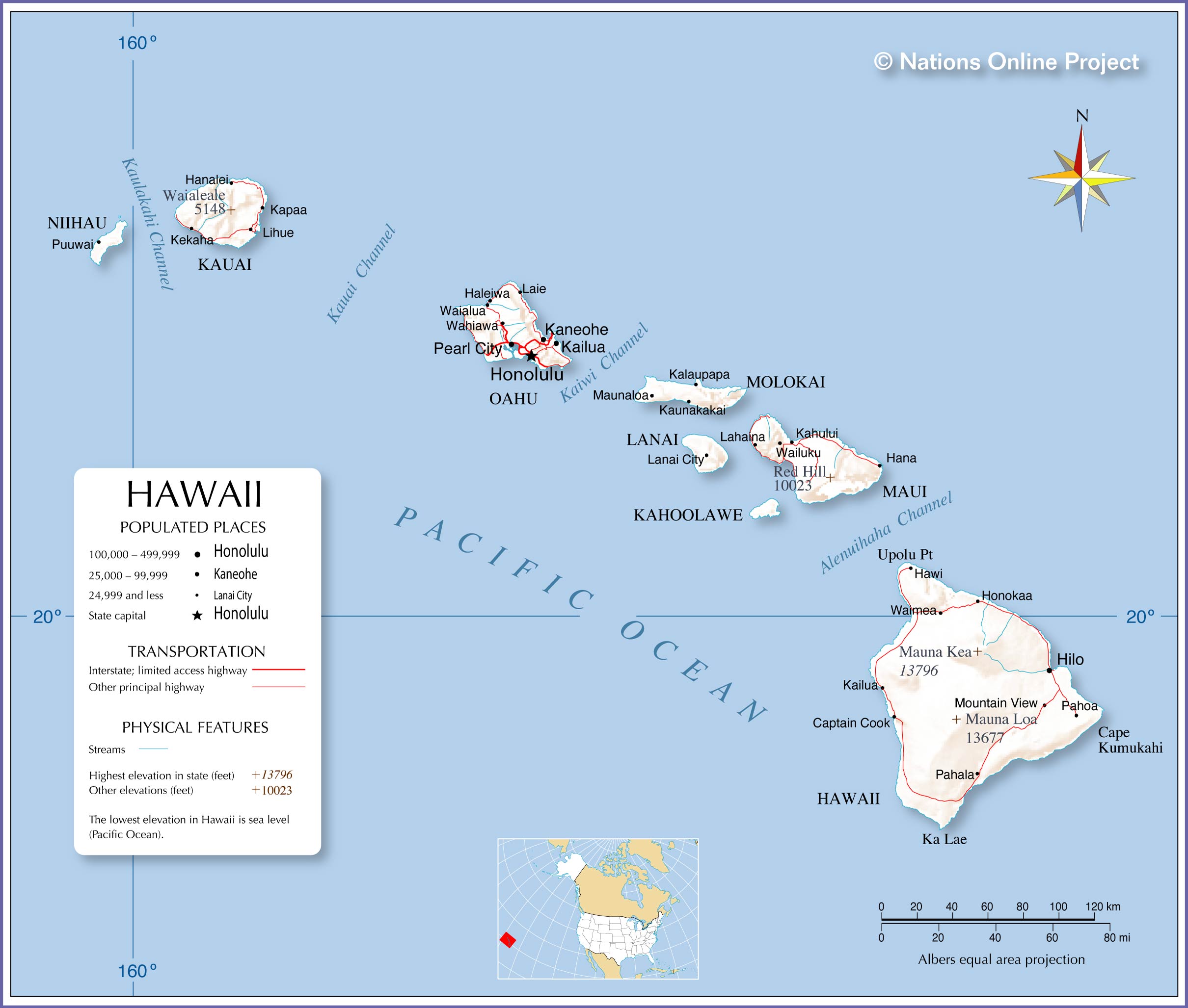Hawaii-map-L.jpg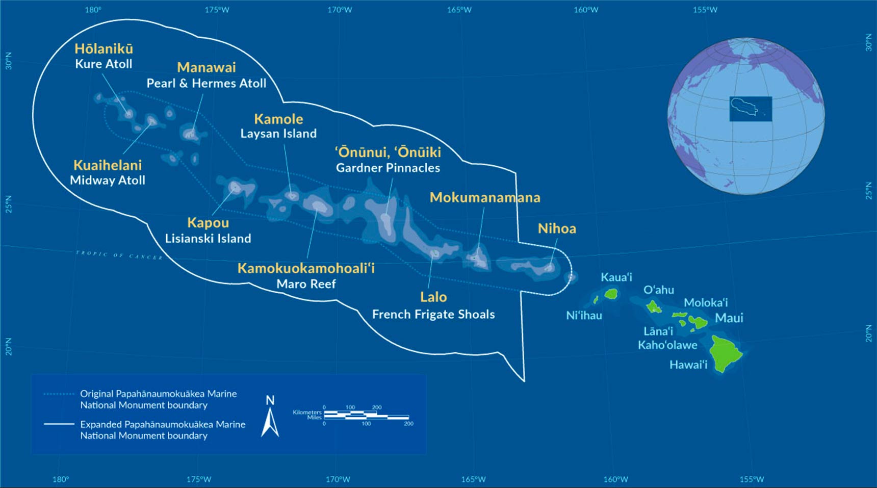Hawaiian-Archipelago-map-L.jpg---
Migrated from Apple Server Wiki. Original page ID: c1a5R5k
# Lab 33: ocean: sea level rise and climate change
- Sea levels are rising due to climate change.
- Check out this page and try a few simulations: [https://coast.noaa.gov/digitalcoast/tools/slr.html](https://coast.noaa.gov/digitalcoast/tools/slr.html)
- Look up Majuro, an island atoll in the Pacific and try it out in your simulation.
- Make a wall map of our island, with the shorelines labeled for every 100 years in the future, if present trends continue.
- Make an island Map of Majuro and do the same thing.
---
Migrated from Apple Server Wiki. Original page ID: 10e359T9
# Lab 23: ocean: coral bleaching and climate change
- Corals are the nursery of the ocean, where all life begins.
- Burning fossil fuels releases carbon dioxide
- Carbon dioxide dissolves in the ocean, making it acidic (lower pH)
- Corals can only survive in a narrow range of pH
1. Research a coral loss simulation of your choice, and make a map of your favorite beach with present coral beds and a prediction of the coral beds every 100 years on the future
2. Explain why corals are only found on the leeward (south west) side of our islands
3. What is the impact of golf course runoff on corals?
---
Migrated from Apple Server Wiki. Original page ID: E6j1f5h
# Lab 36: resources: island energy sources: Hawaii and global
- Our island is energy rich, but resource dependent
- This lab will focus on the energy part, another lab will focus on our resource dependence
- On an island wall map, locate all sources of energy on our island, including large Photovoltaic (PV) arrays, hydroelectric (dams), Geothermal, and wind energy.
- On each location, describe two things:
- is the energy 24 hour, or only part of each day
- at the bottom, list the daily and annual energy use of our island
- daily production in kWh or mWh
- annual energy production in mWh
- explain at the bottom why energy storage is needed here
- Create a global energy map with the same sources listed, and a legend for each
---
Migrated from Apple Server Wiki. Original page ID: H7T0m3L6
# Lab 35a: resources: Hawai'i island disasters and impact
- Our island is dependent on air and barge shipments for everything from Amazon packages to the rice we eat and the fuel oil that makes our electricity and pumps our water.
- We face several disaster threats:
- Hurricane: periodic, seasonal, path is known days or weeks in advance
- Tsunami: sudden, but we know the usual directions for these, and we have some warning in some cases
- Earthquake: no warning on our island, can disrupt power and water supplies for days or weeks
- Wildfire: little warning, but we know the vulnerable areas and weather conditions, can cause power and water outages (why are these usually linked?)
- Flooding: some warning from weather sources, can disrupt roads, power, water supplies and ability to deliver supplies
- On your wall map, make a simulation of each of these, with historical references to each, and how they impacted our life on this island
- Include a legend for each disaster at the bottom
- How is HPA impacted by each?
- If you live on island, how will your home be impacted?
---
Migrated from Apple Server Wiki. Original page ID: D17364
# Lab 36b: resources: Hakalau and beyond
- Start with this page: [https://asnerlab.org/lands/](https://asnerlab.org/lands/)
- Look up the simulations of rapid ohia death and biodiversity on our island
- Check out this link: [https://hawaiibiodiversity.org/](https://hawaiibiodiversity.org/)
- Create a biodiversity threat wall map of our island, including endangered species and any invasive species on your map, with a legend for each
- Look up the Hakalau preserve and include any information on this in your wall map
---
Migrated from Apple Server Wiki. Original page ID: E5n3o9U
# Lab 32: ocean: ocean impact of runoff and sewage
- Online, research the impact of freshwater runoff on our island on the leeward (west) coast
- Focus in on Puako, and research the impact of leaking septic tanks on the shoreline of Puako
- Questions:
- What is a septic tank?
- Where are they in Puako?
- What happens when the tide comes in?
- What happens when the tide goes out?
- What is the impact of golf course runoff?
- What is Eutrophication, and where does it happen?
- What is the "water lens" of a volcano?
- Where can you see the direct impact of this when you swim?
---
Migrated from Apple Server Wiki. Original page ID: \_969o5R
# Lab 21: sky: Hawai'i telescopes
1. Pick one of the observatories on the big island
2. Describe why they are different from the others
3. Explain why having them at the top of Mauna Kea is so necessary
4. Look up the thirty meter telescope (TMT)
5. Explain why the TMT project had positive and negative impact on our island
---
Migrated from Apple Server Wiki. Original page ID: J774g9e4
# Lab 16b: earth: island mapping with GIS
Part one: Underwater GIS
1. connect to google earth at earth.google.com (chrome works best here)
2. look at the Hawaiian island chain, noticing the underwater features
3. look to the NE of Oahu and notice the debris field
4. look up the Nuuanu slide and imagine what a 4000' (1200m) tidal wave would look like
5. find the sixth volcano on our island off the coast of Mahukona and Lapakahi park in Kohala
6. why would the current in the alenuihaha channel be so strong?
7. look up the Holoholo disaster at UH in 1978-why was it so hard to find?
8. how deep is the ocean off the coast of Kona?
9. look up the NELHA project and explain why they put it there
10. look up the NADW and explain further
####
---
Migrated from Apple Server Wiki. Original page ID: 05t2A7e
# Lab 31: ocean: ocean floor mapping
#### 1. Introduction to Ocean Floor Mapping
- Objective: Introduce the concept and importance of ocean floor mapping.
- Activities:
- Warm-Up Question: “What do you know about the bottom of the ocean?”
- Presentation:
- Explain why the ocean floor is mapped (e.g., understanding ecosystems, navigation, natural resource exploration, studying plate tectonics).
- Share key statistics (e.g., over 80% of the ocean floor is still unmapped).
- Briefly introduce mapping methods: sonar, satellite altimetry, and submersibles.
- Media: Show a video or animation about ocean floor mapping (e.g., NOAA or National Geographic resources).
#### 2. Techniques for Mapping the Ocean Floor (20 minutes)
- Objective: Explore the tools and methods scientists use to map the ocean floor.
- Activities:
- Interactive Presentation:
- Sonar (Sound Navigation and Ranging): Explain how sound waves are used to measure depth and create a profile of the seabed.
- Satellite Altimetry: Discuss how satellites measure sea surface height to infer underwater topography.
- Submersibles and ROVs (Remotely Operated Vehicles): Explain how they are used to explore and map areas in detail.
#### 3. Features of the Ocean Floor (20 minutes)
- Objective: Identify key ocean floor features and their formation.
- Activities:
- Presentation with Diagrams:
- Highlight features like mid-ocean ridges, trenches, seamounts, abyssal plains, and underwater volcanoes.
- Discuss how plate tectonics shapes these features.
- Interactive Activity:
- Using google earth, create an island map of the sea floor
#### 4. Application: Importance of Ocean Floor Mapping (15 minutes)
- Objective: Relate ocean floor mapping to real-world applications.
- Activities:
- Case Studies:
- Tsunami Prediction: Explain how mapping helps identify earthquake-prone areas.
- Marine Conservation: Discuss how it informs habitat protection (e.g., coral reefs).
- Search and Recovery: Highlight its role in finding shipwrecks or lost aircraft (e.g., MH370).
#### 5. Hands-On GIS Activity: Visualizing Ocean Floor Data (20 minutes)
- Objective: Use technology to explore real-world ocean floor data.
- Activities:
- Use an online tool like Google Earth Ocean or NOAA Bathymetry Data Viewer.
- Explore and identify key features (e.g., the Mariana Trench, Mid-Atlantic Ridge).
- Questions:
- What is the deepest part of the ocean you can find?
- Identify a mid-ocean ridge and describe its location.
- What patterns do you notice in ocean floor features?
---
Migrated from Apple Server Wiki. Original page ID: E6\_5b5Y
# Lab 18b: sky: island air currents
1. Create a wall map of the island chain with wind direction and air flow around the islands
2. Use windy.com to create layers in different colors for wind flow at different altitudes
3. Look up the water flow around the islands and map this out, with velocities marked
4. Questions:
1. why are the two channels between Hawaii and Maui, Molokai and Oahu the most turbulent?
2. why is the NE wind much stronger in Waimea than it is in Honoka'a or Kohala?
3. why would canoe voyagers avoid the Alanuihaha channel?
4. what other places in the world would be like this?
---
Migrated from Apple Server Wiki. Original page ID: c975n71
# Lab 35b: resources: island water issues
1. Create a wall map of our surface water resources, including watersheds, rivers, and streams
2. Draw a profile map of our island, and to scale include the aquifers on a typical mountain
3. Explain how you might experience freshwater from these aquifers while at the beach
4. Explain why all freshwater wells on this island are "owned" by the Department of Water Supply
5. What would happen to your irrigation well if someone drilled a deeper one near you? why?
---
Migrated from Apple Server Wiki. Original page ID: v553X7y
# Lab 34: ocean: surfing
From Parker Birdsall:
[Download Surfing Lab.pdf (application/pdf, 6.7 MB)](https://bookstack.kamuela.org/attachments/12)
[Download Surfing Lab-2.pdf (application/pdf, 1.1 MB)](https://bookstack.kamuela.org/attachments/13)
[Download Surfing Lab-3.pdf (application/pdf, 227.4 KB)](https://bookstack.kamuela.org/attachments/14)
Teahupo’o
Even the wave’s name means “wall of broken skulls”. It is a hotspot for surfing competitions, known for its big waves and barrels but more than that it is known for its odd form. The reef wave breaks in an odd shape that gains attention—the crescent-shaped break forms this way as it breaks along a large crescent reef in Tahiti. The area breaks exceptionally at around 20ft and was the home of the 2024 Paris Olympic Games. The break season is from April to October and breaks well when the swell is in the southwest direction as waves sweep through the surrounding islands and condense the swell as it approaches the reef. The waveform is perfect at the high wave height due to the rapid gain in seafloor elevation up to the reef.
Competition:
[Kelly Slater vs. John John Florence - Billabong Pro Tahiti 2016 Final](https://youtu.be/35CSnPlFdIs?si=lF-UDrQ6G0iBBOCk&t=111)
Big Surf:
[Biggest, Scariest Teahupoo in Over a Decade](https://www.youtube.com/watch?v=kKU6zezwUoU)
Banzai Pipeline
Banzai Pipeline or just Pipeline is the host of some of the biggest events in surfing. The wave is a go-to for competitive surfing during the winter months as the break offers as close to a perfect barrel as one could hope for. The wave breaks perfectly during the winter months and with a WNW or NW swell pattern. Again, the waves are known because of its ability to hold a perfect barrel even at large sizes. The wave hits the first reef at 15 feet from the surface causing it to shoot up where it leads into varying reef heights from 2-8 feet from the surface, making it extremely dangerous and creating the greatest barrel on earth.
[BEST WAVES IN YEARS (MASSIVE PIPELINE)](https://youtu.be/53KnQ2sNyu8?si=tJ9w5XrikcCIR2V-&t=372)
[Perfect Pipeline With Kai Lenny And The GOAT Kelly Slater!](https://youtu.be/EYlHiTaCoks?si=79qr8HcJ4ukcLLV3&t=175)
Nazaré
Nazaré is one of the most bizarre breaks on the planet. The wave was first documented by foreign wave riders in the 1960s as locals told tourists from the United States of the North Beaches great waves in the winter season. The tourists were sadly only there during the summer and never were able to see these monster waves. It was not until the mid-2000s when a Portuguese bodysurfing local contacted famous American big wave surfer Garret McNamara who would go to fame because of his historic ride on this wave. Nazaré is unlike most other waves with it breaking on a sandbar, making it both unpredictable and typically not very horizontally long as it only breaks to the extent of the sandbar. Breaking on the North beach of Nazaré in Portugal the wave is home to the Nazaré Big Wave Challenge and holds the world record for the largest wave ever surfed at 93.97 feet. Another reason why the break is unique is as the winter season approaches and the WNW swell builds the swell travels through the canyon, allowing it to travel much faster as it approaches the shore. When it hits the canyon wall it shoots up and combines with the slow-moving swell on the side of the canyon to create the biggest wave ever surfed.
[100ft World Record Wave, Garrett McNamara Surfing Nazare, Portugal](https://youtu.be/74pnrYPozcU?si=HBDDnJQJ4J4Xk__g&t=46)
---
Migrated from Apple Server Wiki. Original page ID: J1r0J3M
# Lab 08b: sky: polynesian navigation
Ancient Hawaiians arrived on this island from other islands in the Pacific.
Your job is to trace out these migrations
Navigation module: Homework
1. On your pacific rim map, map out the first voyage of the Hokulea in 1975
2. Trace out the likely migration path of humans from Asia to Hawaii, including Australia, New Zealand (Aotearoa), Tahiti, Easter Island and the others
3. Watch this about the Hokulea voyages: [https://www.youtube.com/watch?v=zvC4LKucDQw](https://www.youtube.com/watch?v=zvC4LKucDQw)
4. Look up "wayfinders" and "Papa Mao": [https://www.youtube.com/watch?v=9IF8jCLxyAA](https://www.youtube.com/watch?v=9IF8jCLxyAA)
5. See also the Nainoa Thompson video at the elab [ NAINOA.m4v](https://elab.hpa.edu/apes/videos/NAINOA.m4v)
6. Video questions follow:
1. where have you seen the paintings of Herb Kane at HPA?
2. what does Hokule'a mean in Hawaiian?
3. what does Hokule'a mean to Hawaiians?
4. why did they bring plants and a pig along?
5. where have you heard of Eddie Aikau?
=====================================
🌊✨ Ocean Navigation by the Stars — Using Star Walk
🧭 Lesson 1 — Finding Direction with the SkyObjective: Understand how stars move across the sky and how their patterns indicate direction.
Key Concepts:
• Apparent motion of stars due to Earth’s rotation
• Polaris (North Star) as a fixed directional marker
• Southern Cross as a southern hemisphere guide
Activity:
1. Open Star Walk and set location to your local coordinates.
2. Observe the sky through the app at sunset and identify Polaris (Northern Hemisphere) or Crux (Southern Hemisphere).
3. Note how the stars rotate around these points using the app’s time-lapse function.
4. Discuss:
>
• Why does Polaris stay still?
>
>
• What does this tell sailors about latitude and direction?
>
>
• How would you find north without a compass?
>
>
Extension:
Draw your horizon and label east, west, and Polaris’ position relative to your latitude.
🌍 Lesson 2 — Latitude from the StarsObjective: Measure and interpret star altitude to estimate latitude.
Key Concepts:
• Altitude = angle above horizon
• Polaris’ altitude ≈ observer’s latitude
• Relationship between horizon, zenith, and celestial sphere
Activity:
1. Use Star Walk to locate Polaris and note its altitude on-screen.
2. Compare to your known latitude (Star Walk provides this).
3. Repeat at different simulated locations (change city in app).
4. Record:
>
• “When Polaris is 0° high, I’m at the equator.”
>
>
• “When Polaris is 90° high, I’m at the North Pole.”
>
>
5. Discuss why southern hemisphere navigators use other stars instead.
Extension:
Students create a mini “sextant” using a straw, protractor, and string to measure altitude of Polaris outside.
🌊 Lesson 3 — Wayfinding Like the PolynesiansObjective: Explore how Pacific navigators used star lines and ocean cues.
Key Concepts:
• Polynesian star compass
• Star rising and setting points
• Integration of ocean swells, wind, and birds in navigation
Activity:
1. Use Star Walk to locate Orion, Sirius, and Pleiades.
2. Note the compass direction where each rises and sets.
3. On a circular “star compass” diagram, label these as navigation points.
4. Discuss:
>
• How could you sail east using star rise/set positions?
>
>
• What if clouds obscure the stars — what other cues could you use?
>
>
Extension:
Watch short video or diagram of the Polynesian star compass (Te Lapa) and compare to your own diagram.
🌅 Lesson 4 — Seasonal Shifts and Ocean RoutesObjective: Understand how seasonal constellations guided long voyages.
Key Concepts:
• Earth’s orbit and seasonal visibility of constellations
• Relationship between star visibility and hemisphere position
• Using changing skies to track time and season
Activity:
1. In Star Walk, advance the date month by month.
2. Watch how constellations rise earlier or disappear.
3. Identify which stars were visible during traditional Pacific voyages.
4. Discuss how ancient navigators planned routes according to seasonal star maps and trade winds.
Extension:
Students write a short reflection:
“If I were sailing from Hawaiʻi to Tahiti, what star paths would I follow, and how would I know when to turn?”
🌌 Lesson 5 — Modern and Ancient NavigationObjective: Compare celestial navigation to GPS and modern instruments.
Key Concepts:
• Transition from celestial navigation → radio → satellite
• How both rely on precise timing and position
• Cultural importance of preserving wayfinding knowledge
Activity:
1. Use Star Walk to simulate positions of key stars during an ocean crossing.
2. Compare how ancient navigators used angular measurements vs. how GPS triangulates satellite signals.
3. Discussion prompts:
• What knowledge is lost if we stop looking at the sky?
• How could modern tools and ancient techniques complement each other?
Extension:
Have students design a hybrid “digital star compass” — combining AR sky data and real compass direction — and describe how it could help sailors or hikers offline.
🧩 Assessments possible:
• Creative Project: Students create a star navigation logbook tracing a fictional voyage using Star Walk screenshots and reflections.
• Performance Task: In pairs, students “sail” across the virtual Pacific, using only star rise/set directions in the app to explain their route.
• Reflection Essay:“What can celestial navigation teach us about observation, patience, and interconnectedness between Earth and sky?”
1. Storytelling
• Begin with a short story of a Polynesian voyage (e.g., the Hōkūleʻa canoe’s modern voyages or ancient wayfinders sailing thousands of miles without instruments). See videos above
• Look up pictures of Polynesian double-hulled canoes.
• Ask: “How could they cross the ocean without GPS, compasses, or maps?”2. Concepts of Polynesian Navigation
• Stars as compass points: Rising and setting stars mark east and west.
• Star lines: Navigators memorized ~200 stars and their rising/setting positions.
• Dead reckoning: Estimating speed/direction over time.
• Environmental cues: Ocean swells, clouds, bird flight patterns.
• Use a globe or map to show how far voyages reached (Hawai‘i, Tahiti, Aotearoa).
3. Star Simulator Exploration
• Open the iPad star simulator (e.g., SkySafari, Star Walk, or Stellarium).
• Find Polaris vs. Southern Cross: Compare northern vs. southern navigation.
• Identify a star line: Pick a canoe course (say east) and have students mark which stars rise/set at that bearing.
• Simulate voyaging at sea: Dim lights, have students “steer” by keeping their iPad pointed at a chosen guiding star.
• Star compass activity: Assign groups a quadrant (north, east, south, west). Each group records which stars rise/set in their direction and shares back to create a full class “star compass.”
4. Hands-On Simulation (Optional Extension, 15 min)
• In pairs, one student is the “navigator” holding the iPad, the other is the “crew.”
• The navigator gives directions based on a guiding star (“Keep the canoe under Orion’s belt, rising in the east”).
• Rotate roles.
5. Wrap-Up & Reflection (10 min)
• Discuss: “What would be hardest about navigating this way?”
• Connect to science: role of Earth’s rotation, star paths, and latitude in navigation.
• Reflection prompt: “If GPS stopped working tomorrow, what knowledge from Polynesian navigation would still help us?”
---
Migrated from Apple Server Wiki. Original page ID: H8S9Y04
# Lab 08a: sky: star walk lab
## Star Walk lab:
Make sure you can use star walk properly:
1. Set your location (you may have to go into privacy settings to do this)
2. Set the proper time
3. Locate the camera icon for night use
4. Try looking at the floor to see stars that will be visible tonight
5. pick out three constellations and three stars that you will share with the class
Part 1: Your latitude and Polaris
1. set the starwalk location to Waimea
2. go forward on the clock to midnight
3. find polaris and look on the info screen for the altitude (degrees above the horizon)
4. compare this with our latitude on the globe
5. take your astrolabe and ipad home and locate polaris using the camera function on at least two nights (it is at the end of the little dipper constellation)
6. also at home, verify the angle for polaris using your astrolabe, bring this angle into class
7. in class, compare your angle with what you find on the GPS from your phone
8. question: if we sailed north 10 degrees, where would polaris be?
9. question: what would be the angle to polaris on the equator?
10. question: could you see polaris from Brazil?
11. question: what do mariners in the southern hemisphere use to determine latitude?
Part 2: Polaris around the globe
1. pick a random place on the globe where you are "lost"
2. set this location on starwalk
3. measure the elevation of Polaris
4. compare with the latitude of your location on the globe
Part 3: Star walk and longitude
1. Longitude is the time difference between Greenwich (near London) and your location
2. Earth rotates 360° in 24 hours, so every 15° longitude on the globe is 1 hour
3. If your local time is ahead of GMT (Greenwich mean time) you are east
4. If you are behind, you are west of GMT.
5. Hawaii is about 155°W longitude, so 155/15 =10.333 10.3 hours behind
Part 4: finding "local noon"
1. ideally solar noon should be at 12:00 but only on a longitude line
2. using star walk, track where the sun is at the highest today using the angle info (it will be around noon, but not exactly)
3. note this time
4. if it is after 12:00, multiply the number of hours by 15° to get our true longitude (30 minutes =0.5 hours 0.5 hours)
5. where are we really? what is our longitude?
Part 5: Challenge: Find me!
1. pick three places on the planet that you are "lost"
2. challenge your classmates to find you based on hours from GMT (time of day at noon GMT) and position of Polaris
Part 5: Mapping the stars
1. Create a large star map on a double folder in three languages: English, Hawaiian and your native language including constellations and their names
2. Make sure to include sirius, orion and the pleiades
3. Make sure to include polaris, and the angle from the horizon we would see it
4. Your map should be from this location, around sunset, so you can compare with what you see live at night
Questions: email for credit
1. what stays the same through the night?
2. what changes?
3. what is the angle of Polaris above the horizon?
4. how does this compare to our latitude?
5. how could you use sunrise and sunset constellations to navigate?
6. when is this impossible (think of our guest)
7. how do waves fit into navigation?
8. on your star walk simulator, change the location to your home town
9. draw a map on the other side of your folder with that star map
10. what is different and same about this? what is missing?
11. change the date on your star walk to your birthday
12. what do you see that is different? same?
13. where is your zodiac sign at midnight on your birthday?
14. why?
---
Migrated from Apple Server Wiki. Original page ID: k0z322
# Lab 08c: sky: my home, my stars
## This is a group project!
We will work in teams based loosely on language and home country
Goal: To create a huge, beautiful map of the stars in this month at sunset, at your home, in your language
Specific notes:Team Brasil: include the southern cross, and the names in Portuguese for each of the major constellations and sunrise-sunset times for 10.21.25 at your home
Team Germany (BRD-DUK): include the angle for Polaris at each of the team homes, and the constellation names in German and sunrise-sunset times for 10.21.25
Team Spain-Italy: include the names of stars and constellations named by the Moors, who lived in Spain, along with constellation names in Español and Italiano, and sunrise-sunset times for 10.21.25 at each location
Team Hawaii: do the same for Hawaiian names, with N, S, E, W labeled in Hawaiian for navigation, and major stars labeled in Hawaiian (e.g. Hokule'a), and sunrise-sunset times for 10.21.25 in Waimea
Team US: do the same for a location in the US (not Hawaii) including the angle for Polaris on your map, and local sunset time and the major constellations, and sunrise-sunset times for 10.21.25 at your location
---
Migrated from Apple Server Wiki. Original page ID: b1B1Y51
# Lab 16a: earth: mapping my home with GIS
Part one: Google earth and my home
1. use google chrome browser to open google earth (earth.google.com)
2. open a new project, and save to google drive
3. locate your home on the earth (can be street or neighborhood)
4. check out street view there
5. print out a color picture of your town (color printer is in the elab)
6. zoom out to include your country, print another picture with your country circled
7. zoom out to include the world, with your country circled
8. pick one of the layers google earth and one of the pictures and print this
9. on a huge paper, glue these together, with a HUGE label on top: My home is---
Part two: Time lapse
1. open google earth on google chrome, click projects->new project->create in google drive
2. find the elab and the HPA campus
3. turn on historical imagery and look back in time: when were the solar panels installed?
4. go back to your home images, and look back in time-what do you notice?
5. use the ruler tool to measure some distance on the HPA campus
6. use the ruler tool to measure the distance from your home to your earlier school
7. measure how far it is from your home to HPA
8. how many meters do you have to walk to get from the elab to the cafeteria?
9. use google earth engine timelapse to see changes in glaciers: [https://earthengine.google.com/timelapse](https://earthengine.google.com/timelapse)
Part three: Simulations
1. open the google earth simulations here: [https://www.google.com/earth/about/gallery/](https://www.google.com/earth/about/gallery/)
2. find a few simulations you like and play
3. check out the climate change simulator [here](https://coastal.climatecentral.org/map/12/204.1701/19.9246/?theme=warming&map_type=multicentury_slr_comparison&basemap=roadmap&elevation_model=best_available&lockin_model=levermann_2013&refresh=true&temperature_unit=C&warming_comparison=%5B%221.0%22%2C%224.0%22%5D#12/19.0250/72.8838?compare=temperatures&carbon-end-yr=2100&scenario-a=warming-4&scenario-b=warming-2) and look at Puako or other beaches on our island
---
Migrated from Apple Server Wiki. Original page ID: V3W4T0C
# Lab 15: ocean: my family, my haplogroup, my migration
Look at this diagram of Native migrations: (click on map to zoom in)
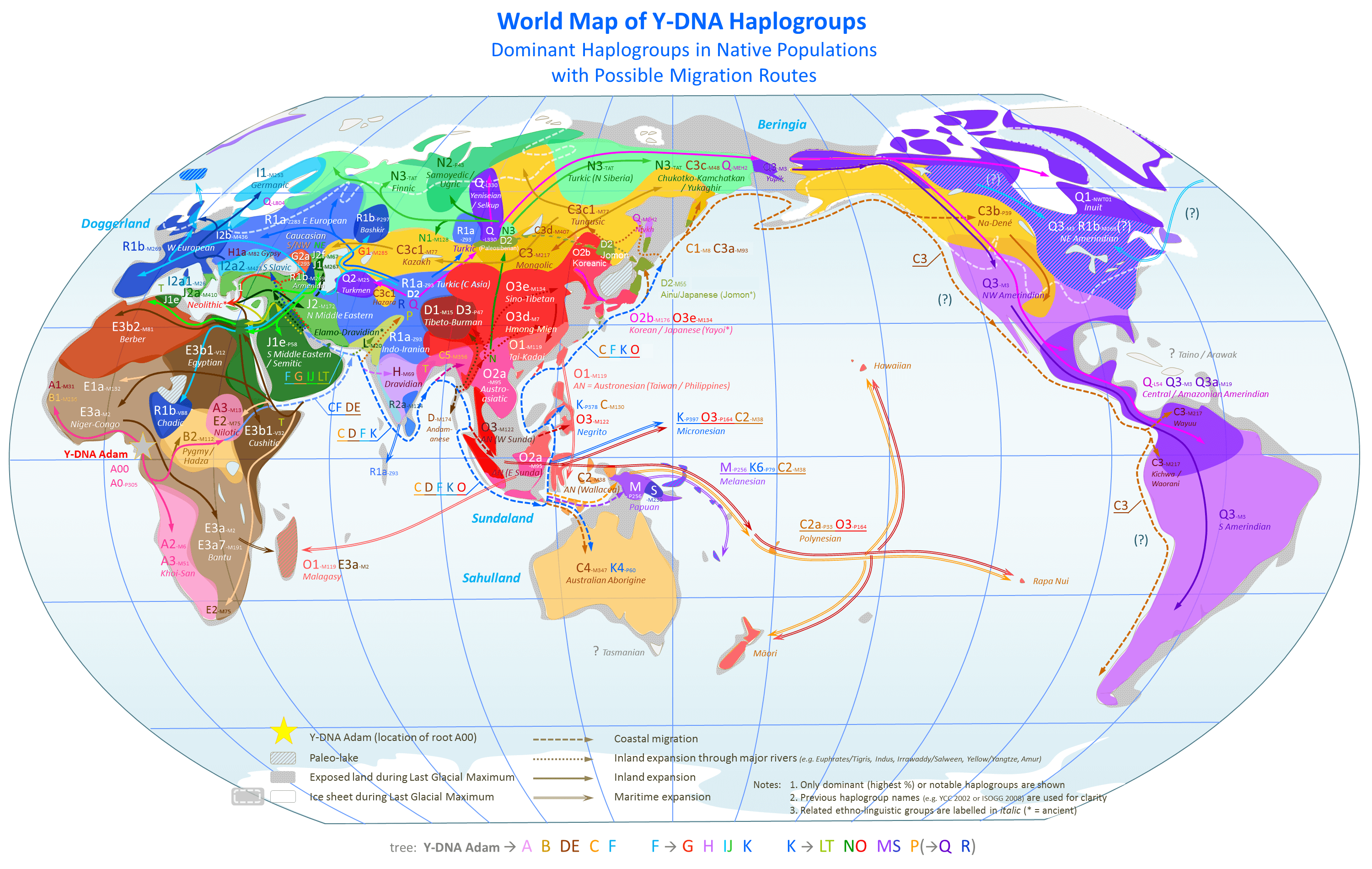World\_Map\_of\_Y-DNA\_Haplogroups.png
Note how the Hawaiians migrated around the Pacific.
Now look up your haplogroups and trace how your people migrated to where you live now.
Check this out: make sure you look at the age in years for each migration:
Blue line is 10,000 years ago until 1,000 years ago when the Polynesians migrated here to Hawaii and Northern Europe was settled (Iceland, Scandinavia, Siberia, Greenland)
Green line is 10,000 years ago to 30,000 years ago when North and South America were populated
Red line is 30,000 to 55,000 years ago, when Asia and Australia were settled, and a migration to Europe occurred from the Middle East and India
Black line is 55,000 to 90,000 years ago, when the first migration out of Africa occurred
Magenta line is the first migration to South Africa and the Sahel 90,000-130,000 years ago
Brown line is 130,000 to 200,000 years ago, the first migration out of Olduvai Gorge in Africa
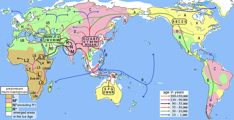Human\_migrations\_and\_mitochondrial\_haplogroups.PNGMigration questions:
1. What is the path of your ancestors?
2. Look up your last name in some genealogy sites-ask your parents what they know about your family history
3. What motivates people to migrate now, and what was the driving force centuries ago?
4. What is inherent in humans to leave home and explore?
---
Migrated from Apple Server Wiki. Original page ID: y659p1c
# Lab 35: resources: sustainable Hawaii?
1. Draw a map of our island, with arrows coming in and out of our island for energy, water, food, and other stuff (technology, machines, repair stuff, building materials, etc.)
2. Track the following through one of your days:
1. where does your breakfast, lunch and dinner come from?
2. how much comes from this island?
3. where does the rest come from and how does it get here?
4. how do you get to work, or if you are a boarder, to town, Kona or the airport?
5. where does the energy to do this come from?
6. where does your water come from?
7. how is it pumped, and by whom?
8. where does the energy to do this come from?
9. how could you change these?
10. how does this compare to the Ahupua'a model you made earlier?
---
Migrated from Apple Server Wiki. Original page ID: n8R7Q9
# Lab 17: sky: weather
Start with windy.com:
1. look up Waimea on windy.com
2. look up the weather in your home town
3. what is the forecast for each place this week?
4. go to elab.hpa.edu and lookup each of these:
1. current elab weather
2. village campus weather
3. waimea weather forecast
4. coastal forecast
5. coastal surf report: is there something like this where you come from?
6. elab air quality
7. vog forecast
8. space weather
9. hurricanes-global and local
5. look up purpleair.com and find the worst air on the planet today
6. find the air quality at your home
7. why is the leeward side of every island dry and the windward side wet?
8. what is the "Hawaiian High Pressure area" and where is it located?
9. Look up the three global air circulation zones and explain why we should have north->south winds
10. now explain why we have trade winds, from what direction, and why are they called that
---
Migrated from Apple Server Wiki. Original page ID: 6442L3s3N
# Lab 01d: Lost friends!
isci map challenge
Your friends are lost! They see each of these peaks at these map angles, find them!
Naomi:
- Pu’u Pa 332
- Nohonohae 336
- Holoholoku 308
Sofia:
- Pu’u Pa 305
- Nohonohae 280
- Holoholoku325
Ivy:
- Pu’u Pa 56
- Nohonohae88
- Holoholoku73
Dominik:
- Hualalai 197
- Mauna Loa 158
- Mauna Kea 111
Philipp:
- Hualalai 270
- Mauna Loa 180
- Mauna Kea 39
Marti:
- Hualalai 292
- Mauna Loa 232
- Mauna Kea 360
Eve:
- Hualalai 360
- Mauna Loa 47
- Mauna Kea 32
[Download Nav quiz.pdf (application/pdf, 41.2 KB)](https://bookstack.kamuela.org/attachments/30)
---
Migrated from Apple Server Wiki. Original page ID: i1s4a183Z
# Lab 12: earth: biome hunt
[Biomes](https://en.wikipedia.org/wiki/Biome) are a way of describing an environment based on rainfall, temperature and altitude, along with proximity to the ocean in our island case. In the diagram below, temperature is on the X axis, while rainfall is on the Y axis in mm of rain per year:
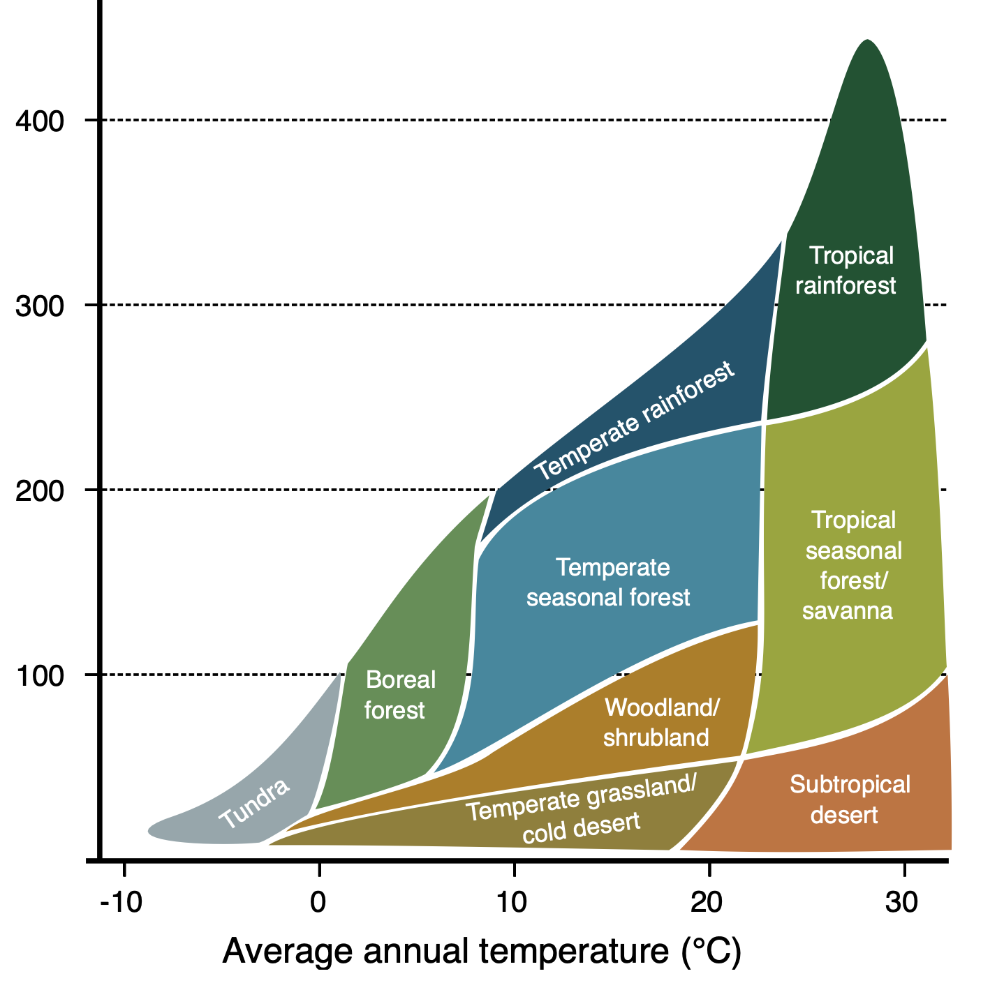Screenshot 2026-02-04 at 6.31.24 AM.pngPart I Challenge: Island of Hawai'i
- Your challenge is to pick 8 random places on your island map, label them 1-8 and challenge your classmates to determine the biome in each location using only google earth and google street view. Part II Challenge: Island chain-Hawai'i to Kauai
- Repeat your hunt for the entire island chain, from Kauai to our island with at least two different biomes for each island where possible (one island has only one biome)
- Your classmates will then identify the biome at each location
Part III Challenge: Global biomes
- Pick 8 random places on the globe and using the same tools challenge your classmates to name the biome for each place
Questions: email before next class
1. what sort of biome tends to be on the southwest side of each island?
2. what sort of biome tends to be on the northeast side of each island?
3. which direction does the wind and rain come from most of the time?
4. which island has only one biome and why?
5. why does our island have so many more biomes than the others?
6. where is the wettest place on earth?
7. why?
8. why is Waipio Valley so wet while Kawaihae is so dry?
9. what seems to determine the biome on an island?
10. what seems to determine the biome anywhere else?
---
Migrated from Apple Server Wiki. Original page ID: y6h4G5
# Lab 07: Earth, moon, sun and stars
Everything rotates
- When you look at a sunrise, is this to the east or west?
- Sunset? east or west?
It turns out that everything in our galaxy rotates in the same direction. If you use North on our globe as "up" and you look down on our planet, it rotates counter-clockwise, every 24 hours.
- We rotate in the same direction around the sun every 365 days.
- The moon rotates around earth about every 28 days.
- The moon rotates itself in the same period, so the same "light" side is always facing us
- Every planet in our solar system rotates in the same direction around the sun (except Uranus, as it was hit long ago)
- Even the sun rotates in the same direction
- If you want a satellite to look down on the same place on earth, it has to rotate in the same direction every 24 hours too.
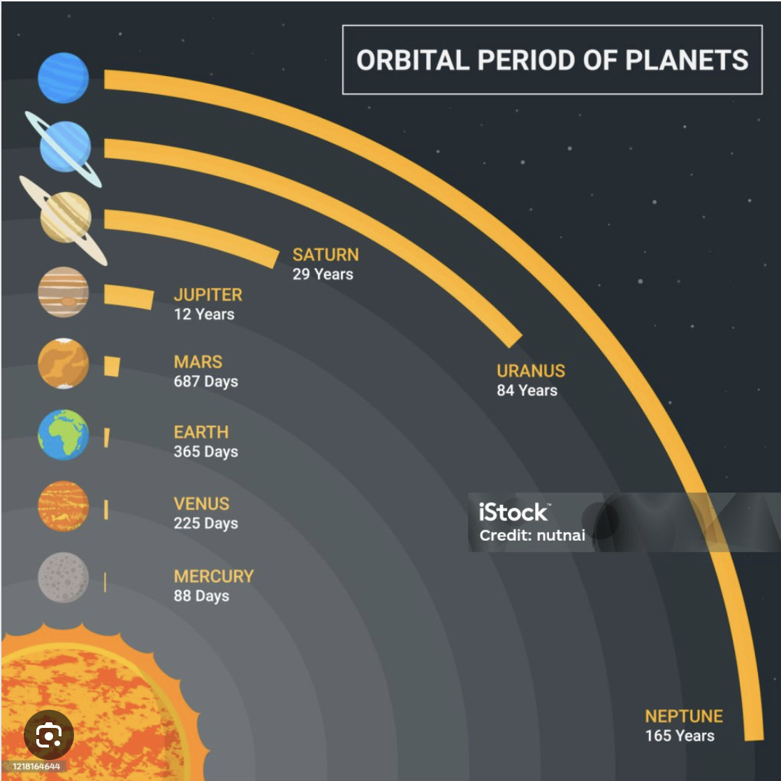Screenshot 2026-02-04 at 8.24.27 AM.png
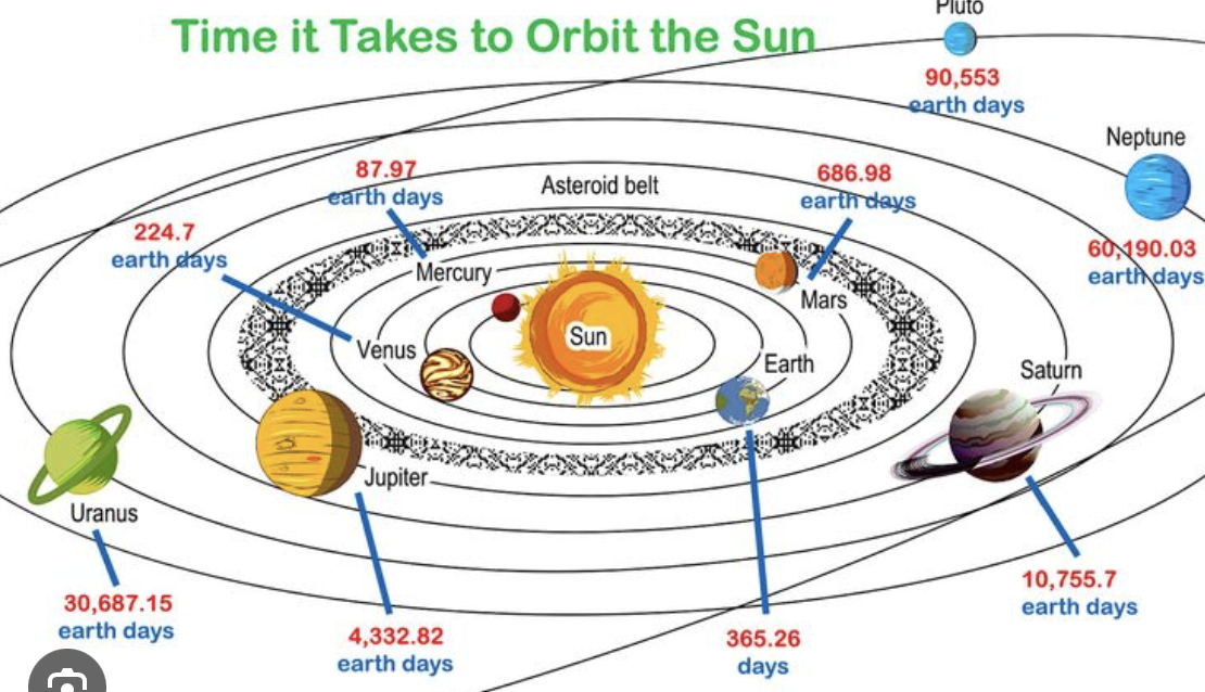Screenshot 2026-02-04 at 8.21.04 AM.pngPart 1: Earth and Moon
Look at this diagram of the earth and moon orbiting:
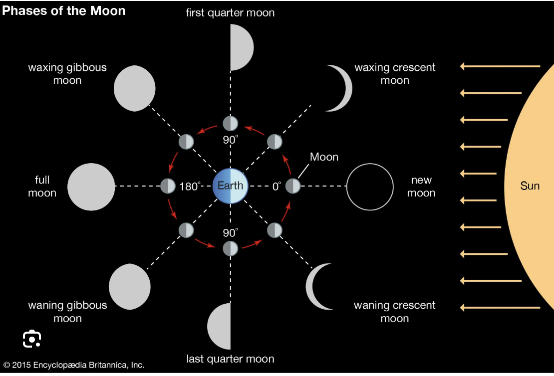Screenshot 2026-02-04 at 8.27.06 AM.png
Here's another view:
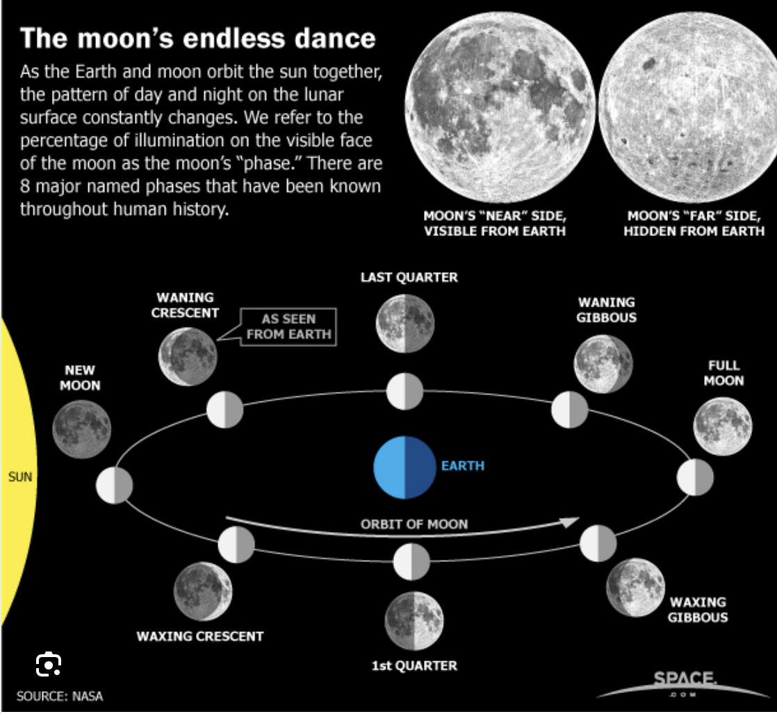Screenshot 2026-02-04 at 9.03.50 AM.pngTry this to visualize the moon phases:
1. stand with your back to the north
2. put your left hand out-this should face east, the sunrise
3. put your right hand out-this should face west, the sunset
4. at sunset:
1. a first quarter moon will be right overhead
2. a full moon will be east, where your left hand points (second quarter)
3. a third quarter moon will be straight down, below your feet
5. at sunrise:
1. a full moon will be setting to the west (best one to remember)
2. a third quarter moon will be overhead
3. a first quarter moon will be straight down, below your feet
Part 2: Earth tilt and shadows
1. stand with your back to the north
2. put your left hand out, this should be east, the sunrise direction
3. put your right hand out, this should be west, the sunset direction
4. at noon the sun should be straight overhead
5. from our work on latitude, your shadow will be on your north side for most of the year
6. on the globe, find Hawai'i and the tropic of cancer-are we above it or below?
7. on the shortest day of the year, December 21, your shadow should be short and to the north
8. on the equinoxes (March 21 and September 21) your shadow will be north of you and about 21° from vertical (our latitude above the equator)
9. since we are between the tropics and the equator, on the longest days of the year, our shadow will actually be SOUTH of us-why?
Part 3: Earth tilt and seasons
Many folks think that our seasons are based on our distance from the sun, but it is actually the tilt (from above) that makes summer and winter, look at this:
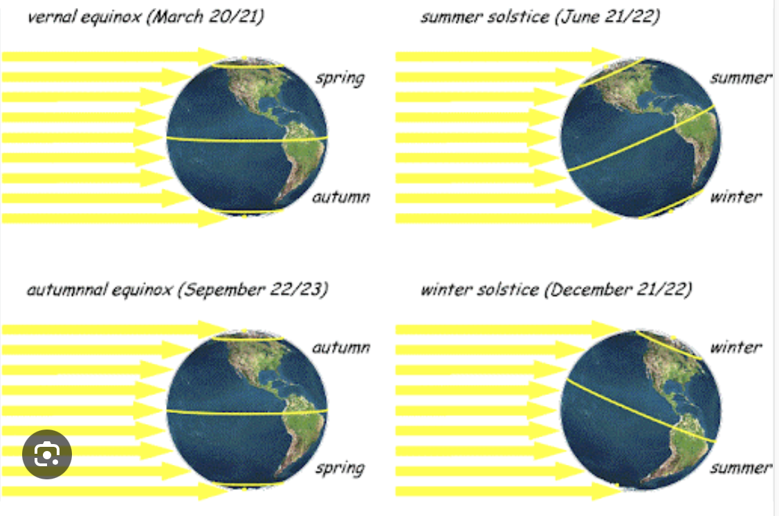Screenshot 2026-02-04 at 9.20.35 AM.png
- This diagram can be confusing: the earth is always tilted at an angle of 22.5 degrees, but as it orbits the sun, this angle is away (winter for us), towards (summer for us) or perpendicular to the sun (equinoxes), so look below:
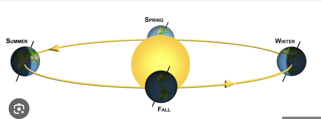Screenshot 2026-02-04 at 9.27.02 AM.png
- From your work on latitudes, notice how at noon on the equinoxes the sun hits every part of the planet at the angle of latitude, e.g. 0 degrees from vertical at the equator, and 90° from vertical at the poles
- Equinox means "equal night" so every part of the planet has a 12 hour day and 12 hour night.
- In Hawai'i our days do get shorter in the winter and longer in the summer, but because we are closer to the equator, this change in angle is not as great as it is near the poles, away from the equator.
Part 4: Earth and constellations
- Ancient folks used the stars to navigate, most importantly the Arabs traveling on the desert, and the Polynesians traveling on the ocean, since in both cases there are no mountains, rivers or other features to navigate by.
- Arabs used the winds to some extent and the Polynesians used the winds and the waves to navigate as well as the stars.
- Have a look [here](https://spaceplace.nasa.gov/constellations/en/) and check out this diagram:
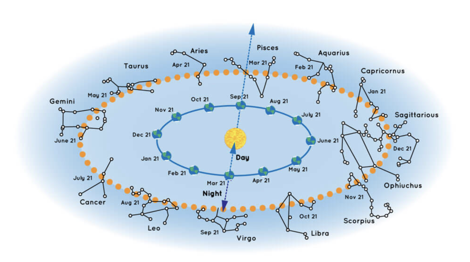Screenshot 2026-02-04 at 9.35.11 AM.png
Now for a surprise: count the constellations
- How many months in a year?
- How many constellations?
- Look up why one was dropped, and which one...
Next: Polynesian navigation-how they used these constellations to navigate around the ocean...
---
Migrated from Apple Server Wiki. Original page ID: 94Z4B4N3
# Lab 06a: making a sundial
You are going to create your own personal sundial so you are never late for class!
There is a pdf below with details on how to do this but first, you have to do some research:
1. using your phone (spyglass or compass) write down the exact latitude and longitude for our location
2. make sure your phone compass is set to true north, not map north, and locate north
3. if you are using they starwalk app on our iPads, look for Polaris, it should be in the same direction
4. research online how to create a sundial or read the pdf below
[Download The Garden Sundial - Much More than an Ornament - J.Warren.pdf (application/pdf, 5.4 MB)](https://bookstack.kamuela.org/attachments/32)
---
Migrated from Apple Server Wiki. Original page ID: b9Y4u6U4H
# Lab 07a: moon, seasons, latitude, longitude challenge
Island Science questions: moon, seasons, latitude, longitude
1. At sunset, the moon is directly overhead, which phase is this?
2. Where will it be at sunset in the third phase?
3. Where is a full moon at sunrise?
4. ideally, how long is the night on March 21 anywhere in the world?
5. How long is the daytime on September 21 anywhere in the world?
6. why is our sunset not at 6 PM on the equinox?
7. on the first day of summer, is earth closest or farthest from the sun?
8. You are sailing from Tahiti to Hawaii, when can you first see Polaris at night?
9. What star could you use while in Tahiti to navigate?
10. Local noon for you is at 12:30 PM and you are between -10h GMT and -11h GMT, where are you?
11. Your latitude is 18°N, are you on land or at sea?
12. What is your local noon and latitude if you are on the north west Hawaiian islands?
13. What is your local noon and latitude if you are in Johannesburg, South Africa?
14. Find a person at +5.5h GMT and latitude 35°N
15. The moon is in third quarter, you see the moon directly overhead, what time is it?
16. You are zooming with folks in another country, and notice the shadow behind them is 35° pointing south, and their clock says noon, while it is 9 AM in London. Where are they?
17. You are planning a walk around campus in the next few months before graduation. What dates are best for this sort of walk if you want to see where you are by moonlight?
18. At sunrise, you see an image of the moon with the curved part facing east directly overhead. What phase is this, and where on the globe are you?
19. A full moon rises at sunset, what time will it be highest in the sky?
20. What time will it set?
21. A waxing crescent is visible in the western sky just after sunset, what phase comes next?
22. On June 21, which hemisphere receives more direct sunlight?
23. If you are at 23.5°N on the summer solstice, what does your shadow look like?
24. A kayaker says:” the moon rose around midnight, it looked half illuminated, and the bright side was on the left” What phase is the moon?
25. What time of month is it?
[Download earth-moon-explorer.html (text/html, 39.4 KB)](https://bookstack.kamuela.org/attachments/33)
Earth–Moon Explorer: Phases • Latitude • Longitude • Seasons
# Earth–Moon Explorer
Interactive: Moon phases • Latitude & Polaris • Longitude & time • Seasons & tilt
**Tip** Use Space to play/pause Reset
Moon Phases
Seasons
Latitude
Longitude
Moon position in orbit (degrees)
0° (New) → 180° (Full)40°
Observer time of day
0 = midnight21.00 h
Animation
Play Step +5°
**Waxing Crescent**
Illuminated: **—**
**Try this:** Slide the Moon to 180° and set time to 0h (midnight). What phase do you see and where is the Sun?
### Quick Check
If the Moon rises at sunset, what phase is it?
Check
Day of year
~172 = June solstice172
Earth axial tilt (degrees)
Real Earth ≈ 23.5°23.5°
Observer latitude
-66.5° to +66.5°19.0°
Season: **—**
Day length: **—**
**Try this:** Set latitude to +19° (Hawaiʻi). Drag the day-of-year across the year. Notice how day length changes only a little near the tropics.
### Quick Check
What causes seasons (one phrase)?
Check
Your latitude (degrees)
Polaris altitude ≈ latitude (N hemisphere)19°
Polaris altitude: **—**
Visible? **—**
**Rule:** In the Northern Hemisphere, Polaris’s height above the horizon (in degrees) is about your latitude.
### Quick Check
If Polaris is 25° above the horizon, your latitude is:
Check
Local clock time when the Sun is highest (local noon)
This slider is GMT/UTC time at your local noon14.00 h
Time difference: **—**
Longitude: **—**
**Rule:** 1 hour of time difference = 15° of longitude. If your local noon happens when GMT is later, you are west of Greenwich.
### Quick Check
If local noon happens at 2 PM GMT, your longitude is:
Check
---
Migrated from Apple Server Wiki. Original page ID: r160f4
# Lab 14: earth: island water
In the Hawaiian language, we have two concepts of water:
- "wai" means freshwater, usually from rain, running in streams or rivers
- "kai" means saltwater, usually in the ocean or pools
There are exceptions to this:
As you know we are the Ka Makani, or "the wind", as "ka" is the definite article in Hawaiian, and "makani" means wind.
Our rain is called the "kipu'upu'u" or needle rain as it comes in sideways, driven by the wind, and feeling like needles on the skin.
Rain becomes "wai" which then runs into "kai".
Two more exeptions:
- anchialine ponds: near the shore fresh water runs under lava flows and forms ponds with a mixture of fresh and salty water
- water lenses: these are places near the shore where freshwater mixes with salty water, but not in a pond, like at Hapuna beach on the north side, or Kohala coast north of Kawaihae
- fun fact: when cattle were brought down to Kohala to be loaded onto boats, they would put their heads underwater to drink the cooler fresh water just under the ocean surface
Your project:
1. look up a "water lens" and create an accurate cross sectional diagram on your big map of the water flow from rain falling on a basaltic volcano like ours and reaching the shore
2. research where these water lenses show up on the west shore, where you might go to the beach
3. research anchialine ponds on the same coast-why there?
4. map out the major streams around Waimea, and explain how diverting these has changed the coastal areas (look up these changes, from the 1950's). [https://www.youtube.com/watch?v=Gp3\_FXu5ULA](https://www.youtube.com/watch?v=Gp3_FXu5ULA)
5. look up the formation of the boat harbor at Spencer Beach (you can find old videos about this on youtube)
6. go back to your island map and map out the pelekane watershed
7. explain why hikers are not permitted in the watershed areas above our campus
8. explain why Waipio valley is so wet compared to the Kohala coast
9. look up orographic lifting and tie this into your answer above
10. explain why every southwest coast of every Hawaiian island is dry
11. explain why Kahoolawe is a desert island
12. look up the shape of the Koolau mountains on Oahu and explain why the northeast side is different from the southwest side
13. on your big island map, list the annual rainfall in each of the major town on the island
14. since we don't have any major rivers on our island, how does all of the rain reach the ocean?
15. what part of the water cycle reaches the reef and what is the impact?
16. who owns every well on the big island and why?
---
Migrated from Apple Server Wiki. Original page ID: Y5L6c8
# Lab Final: amazing mystery island
Where is the island located?
It can be in any sea on earth.
- It is an island, after all...
Must include:
- Latitude and longitude
- Island population between 2-1000
- At least 3 streams from mountains to sea
- At least 3 ahupua’a bounded by ridges with a stream in the middle
- A renewable energy source
- At least one active volcano
- At least 3 biomes
Flora and fauna:
- Pigs.
- Chickens
- 1 animal of choice (NOT a unicorn)
- Each animal can be any known or unknown breed.
Transportation:
- to and from the island (no spaceships or teleportation)
- around the island (bike, ev, emoped?)
A structure:
- House at least 2 people comfortably and safely.
- Sustainable: made of local materials
- Harvest your own energy (solar, tidal, geothermal-no nuclear or fossil fuels)
- Grow your own food for two people year round
- Harvest your own water for two people, year round
- Purify water (this can be filters, but no chlorine)
Questions: to be added as text boxes on your awesome poster of awesomeness:
- What seasons it it has and how do the seasons affect the island?
- Which angle the sun dial has to be at in order to work properly?
- How many hours from GMT. (East or west)?
- What is the weather on your island?
- How could I get there from a spot you choose on the planet (navigation)
- What stars could you see from there?
- What is the ocean like around your island (reefs, surfing, fishing)?
- Pick a spot on your island for an earthquake and pick another spot farther away and show the P and S waves in a sample diagram, including times
- If a person were lost on one part of your island, locate them using peaks (triangulation)
- Calculate the altitude of the tallest volcano or mountain using tangent
- Show at least one part of your island that is vulnerable to tsunamis, and another that is protected
- Draw a line on your island of the predicted sea level in 2100, when you are about 90 years old
---
Migrated from Apple Server Wiki. Original page ID: 6869J8E