
Semester 1 notes
Migration
Chapter in3 progressModules for6-8 Movement of energy and matter
Module 6: Movement of energy
Biosphere-all life
Producer (also primary producer) gets energy from sun or heat directly, also known as autotrophexample: grass
Photosynthesis: CO2 + water + energy (heat or light) -> sugars (CHO)Reverse process is respiration: Sugars + O2 -> energy + CO2 + water
Anaerobic respiration (e.g. bacteria) don't use O2, less efficient, older primitive source of energy (pre-oxygen)
- Primary consumers eat plants (e.g. herbivores)
- Secondary consumers eat them (carnivores)
- Tertiary consumers eat other carnivores (algae->zooplankton->fish->eagles)
- Scavenger-eats dead stuff
- Detritovore-eats dead stuff that is decaying
- Decomposers-break down into basic elements
Not very efficient, unless you can't digest grass, or it takes too much energy to walk around all day. This IS, however a good argument for global sustainable survival, as the sun will not go away soon, and as long as we have arable (farmable) land to grow plants, we could survive with a global population of 8-10 billion.But we'd need access to fresh water...Recall: energy->water->food->culture
Module 7: Movement of MatterBiogeochemical cycles: bio=life geo = minerals chemical = chemical cycle = something that rotates
Hydrologic (water) cycle:Heat provides energy for evaporation,
Runoff-just like it soundsYou will need to know about "transit time" which is the time it takes rain to reach a water body after hitting the groundWhy is this crucial?(you will see this mentioned in the Poisoned Waters video this weekend)
Carbon cycle: photosynthesis, respiration, exchange, sedimentation, burial, extraction, combustionair<->water<->land
Nitrogen cycle:6 macronutrients needed by plants: N,P,K, Ca, Mg, S (sulfur becomes part of Methionine, an amino acid)NPK from fertilizersN is a limiting nutrient
Questions:
- Define N, P, K and how each impacts plants
- Define evapotranspiration, condensation and precipitation
- Which biogeochemical cycle only has a solid phase in the environment?
- What element replaces oxygen in chemosynthesis?
It also means bringing N2 gas from the atmosphere into the biome, biotically or abiotically (without life)
denitrification: NO3- goes to N2O to N2 gas (anaerobic bacteria, swamps)
Phosphorus cycle:Mainly rocks, between land and waterONLY SOLIDS, NO LIQUID OR GAS PHASE
Ca, Mg and K: dust (Kauai dependent on Gobi desert dust for K)
Here's something interesting:Find Sulfur below:
Ok, now find Oxygen.Hydrothermal vents use sulfur instead of oxygen for a thermal (heat) version of photosynthesis called chemosynthesis
Module 8: Response to disturbances
Resilience is how fast the pendulum (ecosystem) returns to normal
Watershed: drainage basin usually leading to a large body of water (Chesapeake watershed is huge):https://www.cbf.org/about-the-bay/chesapeake-bay-watershed-geography-and-facts.html
- How do you think this impacts the water quality, phosphates, nitrates and silt in the Chesapeake bay?
- Why are we not allowed above the fences behind Pu'u La'e La'e?
- On Oahu, the watershed is guarded by a barbed wire fence-why?
- How are the Himalayas acting as a watershed?
- why is the soil on Kauai so poor, and how does it get its Potassium?
- how does the size of the Cheseapeake watershed impact eutrophication in the Chesapeake bay?
- what is the difference between resistance and resilience in natural systems?
- why do rotting fish smell so bad?
Summary notes:Systems
- systems are usually connected, exchange matter and/or energy
- main energy source is our sun, or past suns (e.g. uranium)
- feedback loops (again)
- spheres: litho=stone, bio=living, hydro=water, atmo=above
- geosphere: crust-mantle-core-inner core (spins, no way!)
- plates-who thought this up? need to understand convection
- where are oldest parts of crust? trick question
- subduction zones, mid atlantic ridges (atlantis?)
- eq: deep near subduction zones, shallow in transform faults
- mid atlantic ridge: how do we know this? submarines
- himalayas-how? matterhorn-what?
- water cycle: evaporation and transpiration (eTO)
- precipitation-condensation is first (condensation nuclei, e.g. vog)
- aquifers-underground lakes, low turnover rate (pesticides) Oglalla
- water can be ground water: aquifer, water table, water lens or surface water
- conservation of matter (neglect E=mc2)
- nutrient cycles: carbon, oxygen, phosphorus, nitrogen COPN
- primary producers-photosynthesis: CO2, water and light/heat
- create sugar as stored food, structural element
- consumers-eat primary producers, decomposers break down waste/detritus
- cellular respiration (flowers in hospitals) at night
- carbon also in HCO3- ion (seawater) and CaCO3 (seashells, limestone)
- greenhouse effect from CO2 captured as plants->oil/coal "carbon bank"
- phosphorus: rocks and water (stone and sea), erosion, very limited supply in biosphere (Waterloo bones)
- P only absorbed in aqueous form (aq)
- too much = eutrophication (also nitrogen) see dead zones
- eutrophication: too much of a good thing, when algae dies, decomposes, creates hypoxic zones
- aerobic vs. anaerobic bacteria-wounds
- nitrogen cycle-NPK
- N2 to life: lightning and bacteria (N2 to ammonia NH3 then to NO2 and NO3 (plants absorb NO3)
- denitrifying bacteria change NO2 back to N2 (gas)
- Haber process
- See figure 3.30-nitrogen uptake
- golf courses-Mauna Kea, iBoat
http://physics.hpa.edu/physics/apenvsci/videos/poisoned_waters/poisoned_waters.m4v
Weblog page:http://physics.hpa.edu/groups/apenvironmentalscience/weblog/973c4/Poisoned_Waters_videoPBS.html
On campus try these:http://physics.local/physics/apenvsci/videos/poisoned_waters/POISONED_WATERS.mp4
http://physics.local/physics/apenvsci/videos/poisoned_waters/poisoned_waters.m4vhttp://physics.local/groups/apenvironmentalscience/weblog/973c4/Poisoned_Waters_videoPBS.html
e2: Portland-sense of place
e2: Portland-sense of place
- Morgan Freeman or Brad Pitt?
- What is urban sprawl and what technologies enable it?
- Portland was one main shipyard producing “Liberty Ships” in WWII. What drove their economy after that?
- Portland was on the path of suburban sprawl in the 1960's. What happened?
- What does this have to do with “Food Deserts”?
- 1973 was a pivotal year there, what happened, driven by which group?
- What was the initial reason for the mandate, and what was the final result according to Charlie Hales?
- Look up Charlie Hales, what was his job after this film (2009).
- How many years before his tram project was the last urban streetcar project in the US?
- Explain an urban growth boundary (UGB).
- Accessibility vs. mobility is the choice they made, like in Switzerland, as well as other European cities. What do you see in the video that you might also see in Europe?
- What things in the video do you recognize that show a bike friendly city?
- Who is the first class passenger in Portland, and how does this compare to Los Angeles or other similar city?
- What is a “sustainable urban lifestyle”?
- Cities in Europe have vibrant city centers, and are great cities to walk around. How is this done in Portland?
- Explain "trip behavior".
- How much did property values increase in the Pearl district after the trolley went in? Why? (note the amount of glass in each trolley). http://www.explorethepearl.com/
- Michael Powell of Powell’s books compares buses (“tire-d” transportation) with permanent tracked transportation-what are the differences according to him?
- How did he sell this idea to the property owners there? Was he right?
- For what reasons would an electric tram or trolley be greener than a fossil fuel car or even a standard bus?
- Portland required that every building have street level shops, and limited parking-why?
- Why would people want to live along a trolley line? Why is quiet key to this?
- Where in Europe do they also have aerial trams, and do you notice a trend?
- How does an aerial tram like at OHSU enable different growth trends?
- If the annual growth rate there is 4%, what is the doubling time in years? (Remember the rule of 70)
- This film was made in 2009, so what year will the population be doubled from then?
- What would be different without the tram (parking, traffic, time in car, development)?
- The young mom says “we did not want to spend all that time in the car”. What is she talking about?
- Explain "lifestyle migrants".
- What is "gentrification"? Where else have you seen this? (hint: look up the term "landed gentry") https://en.wikipedia.org/wiki/Gentrification
- What does the man mean about a "burlap future”?
- What is the difference between aspiration and acquisition?
- How does the concept of choice resonate with values in this country? What do you think?
- Bring this home: what would you do at HPA to make it more sustainable? What about Waimea? Hawaii in general? Your home?
APES Sem 2 2021-2022
APES Sem2
Housekeeping items:
- Syllabus reminder: FIRST missed homework is dropped
- HW fixed at 20% (no effective change for you)
- Please bring iPads to class
Recall: energy->water->food->culture
In semester one, we learned about the building blocks of these concepts.
In semester two, you will see them integrate more and more...
Earth 2022 -> Mars
"go west young man"
Sustainability 2022: Semester two
- Conservation/Land use
- Energy
- Pollution/climate change
How can you describe deep nature to someone who has never seen it?
Land Use: Chapter 10, modules 29-30
Homework: Chapter 10 PQ and chapter questions
email: GPS ranching-why is this closer to pre-contact buffalo herds?
Econ students may know this one:Externalized costs, externality: shedding financial responsibility for your impact the the wholee.g. Minamata: https://en.wikipedia.org/wiki/Minamata_disease
Conservation movement: Important peepsRalph Waldo Emerson-"Nature" "behind nature, throughout nature, spirit is present" 1837https://en.wikipedia.org/wiki/Ralph_Waldo_Emerson
Henry David Thoreau-Walden "truth in nature and wilderness over the deceits of urban civilization". 1845https://en.wikipedia.org/wiki/Henry_David_Thoreau
Ansel Adams: Photographer championed the National Parks: 1920-1980http://physics.hpa.edu/physics/apenvsci/videos/ansel_adams.mp40:00-8:00
"More than any other artist of the century, he would help transform the meaning of "wilderness" in America and change what people thought and felt about their own land"
"it's a place that you step into, and you don't know what's going to happen, a place that can surprise you, it's a place where you are small, where being small is not a bad thing, where being small is actually a wonderful thing"-Carl Pope, Sierra Club
"...the world is beautiful, that humanity is part of this larger world, that the concerns of the moment are part but not separate from a larger system of forces that that connect us to all of creation"Jonathan Spaulding, Biographer
Question: How did his photographs change the awareness of the public? People usually care about what they know...
Aldo Leopold-environmental ethics, wildlife management, conservation, Sand County Almanac (Wisconsin) https://en.wikipedia.org/wiki/Aldo_Leopold
John Muir-started the Sierra Club: "wilderness mirrors divinity, nourishes humanity and vivifies the spirit"https://en.wikipedia.org/wiki/John_Muir
Rachel Carson-silent spring DDT (persistent pesticide, weakens bird egg shells), 1963:https://en.wikipedia.org/wiki/Rachel_Carsonhttps://en.wikipedia.org/wiki/Dichlorodiphenyltrichloroethane
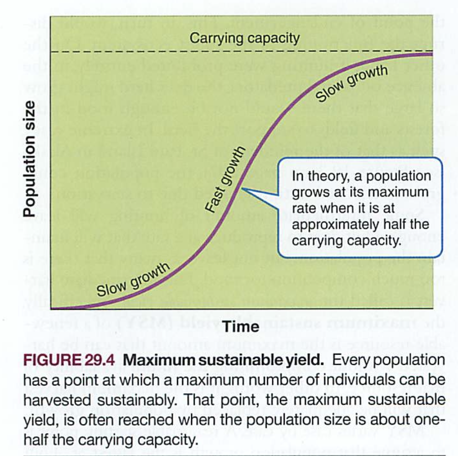
MSY: maximum sustainable yield: max renewable output without compromising futureSee: native peoples: "seventh son of seventh son"Also: "Sustainability = thinking about forever"See diagram in chapter, greatest growth is at 50% of carrying capacity (there's that word again!)
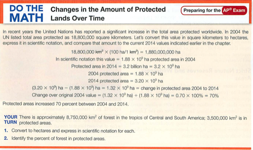
Protected lands:
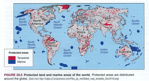
See also Amboseli in Kenya, Serengeti in Tanzania (Tanganyika+Zanzibar), Kruger park in S. Africa (Afrikaans)Public LandsIn the US, we classify public lands as Rangelands-open range, enables some ranching with leases National forests-old growth and new growth, limited forestry National parks-national treasures, limits on visitors, infrastructure (e.g. Denali)National wildlife refuges-usually associated with an endangered species or transit/migration path (e.g. wolves)Wilderness areas-no development, often noise abatement as well (think of helicopters in Waipio or Haleakala)
We have several of these here in Hawaii:Kilauea Volcano (Madame Pele)Haleakala ("House of the sun")Honokohau ("City of Refuge")Pearl Harbor Pu'u Kohola (Whale Heiau)Papa hanau moku a kea-Northwest Hawai'ian Islands NWHI
Federal lands: owned by the people, but can be leased to individuals
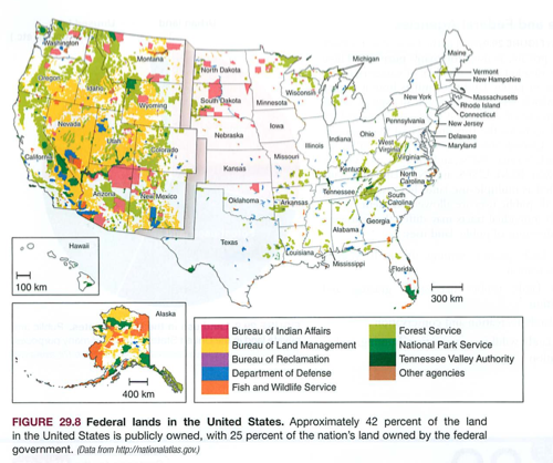
Two ethics are in competition:Resource conservation ethic-maximum use based on greatest good for everyone, usually preservationMultiple use lands-designated lands for grazing, timber, minerals, leased to individuals or companies for profit
Land Management in the US:BLM: Bureau of land managementGrazing, ranching, monitors rangeland health, erosion
USFS: Us Forest ServiceManges timber harvesting, where, how, what treesOld growth vs. new growth, replanting, clear cut?
FSC: Forest stewardship council:FSC certification: no clear cut, no damage to land, replanting, selective cutting, underbrush considerationsHUGE debate over underbrush, USFS believes in regular forest fires to deplete the amount of underbrush (as in nature)See also California and Australia wildfires: drought, no regular fires, buildup of underbrushSee Yellowstone fire of 1988-result of overgrowth of underbrush
Forests: clear cut vs. selective cutFSC wood-how different?https://en.wikipedia.org/wiki/Forest_Stewardship_Council
Fire management: Yellowstone fire 1988https://www.northcountrypublicradio.org/news/npr/94114095/series-overview-yellowstone-s-evolution
USFS prefers many small fires, removing flammable underbrush
NPS: National park serviceManages parks for recreation, multiple use ethic, preservation of timber, minerals and "natural curiosities"Also significant native peoples monuments (see above)
FWS: Fish and wildlife serviceManages fishing and hunting on all public lands
Know these:BLM: Bureau of Land Management USFS: US Forest Service NPS: National Park Service FWS: Fish and Wildlife Service
NEPA: National Environmental Policy Act 1969 (why then?) mandates an EIS for all developmentEIS (environmental impact statements) are new standard for any projectESA endangered species act-often brought in where development could impact ES
Charlie Hales Mayor of Portland 2013-2017
Videos:
Land Use: Modules 29-30


email: GPS ranching-why is this closer to pre-contact buffalo herds?
Tragedy of the commons (old idea, new article) 1968 Garret Harding KNOW THIS...An old 1833 concept from farming villages, article updated in 1968 this to include rivers, streams, ocean, air...https://en.wikipedia.org/wiki/Tragedy_of_the_commons
Econ students may know this one:Externalized costs, externality: shedding financial responsibility for your impact the the wholee.g. Minamata: https://en.wikipedia.org/wiki/Minamata_disease
Conservation movement: Important peepsRalph Waldo Emerson-"Nature" "behind nature, throughout nature, spirit is present" 1837https://en.wikipedia.org/wiki/Ralph_Waldo_Emerson
Henry David Thoreau-Walden "truth in nature and wilderness over the deceits of urban civilization". 1845https://en.wikipedia.org/wiki/Henry_David_Thoreau
Ansel Adams: Photographer championed the National Parks: 1920-1980http://physics.hpa.edu/physics/apenvsci/videos/ansel_adams.mp40:00-8:00
"More than any other artist of the century, he would help transform the meaning of "wilderness" in America and change what people thought and felt about their own land"
"it's a place that you step into, and you don't know what's going to happen, a place that can surprise you, it's a place where you are small, where being small is not a bad thing, where being small is actually a wonderful thing"-Carl Pope, Sierra Club
"...the world is beautiful, that humanity is part of this larger world, that the concerns of the moment are part but not separate from a larger system of forces that that connect us to all of creation"Jonathan Spaulding, BiographerQuestion: How did his photographs change the awareness of the public? People usually care about what they know...-----Land use:MSY: maximum sustainable yield: max renewable output without compromising futureSee: native peoples: "seventh son of seventh son"Also: "Sustainability = thinking about forever"
Protected lands:
Public lands: often victim of economic predation (e.g. Burma illegal logging)Other side: NRDC and others, purchase lands to protect them from predatory practices (e.g. Amazon basin)In the US: National Parks are one example of a national recognition of several things:1. Spiritual/psychological benefit to nature2. Preservation of resources for future generations3. Recreation4. Habitat preservation for species (can be land, ocean, islands, etc.)
See also Amboseli in Kenya, Serengeti in Tanzania (Tanganyika+Zanzibar), Kruger park in S. Africa (Afrikaans)Public LandsIn the US, we classify public lands as Rangelands-open range, enables some ranching with leases National forests-old growth and new growth, limited forestry National parks-national treasures, limits on visitors, infrastructure (e.g. Denali)National wildlife refuges-usually associated with an endangered species or transit/migration path (e.g. wolves)Wilderness areas-no development, often noise abatement as well (think of helicopters in Waipio or Haleakala)
We have several of these here in Hawaii:Kilauea Volcano (Madame Pele)Haleakala ("House of the sun")Honokohau ("City of Refuge")Pearl Harbor Pu'u Kohola (Whale Heiau)Papa hanau moku a kea-Northwest Hawai'ian Islands NWHI

Two ethics are in competition:Resource conservation ethic-maximum use based on greatest good for everyone, usually preservationMultiple use lands-designated lands for grazing, timber, minerals
Changes:
Let's check out these guys again:English folks might recall Emerson, Thoreau and WhitmanConservation movement: Important peepsRalph Waldo Emerson-"Nature" "behind nature, throughout nature, spirit is present"https://en.wikipedia.org/wiki/Ralph_Waldo_Emerson
Henry David Thoreau-Walden "Truth in nature and wilderness over the deceits of urban civilization"https://en.wikipedia.org/wiki/Henry_David_Thoreau
Teddy Roosevelt- ca. 1900, National Parkshttps://en.wikipedia.org/wiki/Theodore_Roosevelt
http://physics.hpa.edu/physics/apenvsci/videos/national%20parks/
First two minutes, start again at 7:00-10:00Note influence of railroads in parks as well as all lands in the west (Leland Stanford, for example)"Americans think 100 years is a long time, and Europeans think 100 miles is a long distance..."
Aldo Leopold-environmental ethics, wildlife management, conservation, Sand County Almanac (Wisconsin) https://en.wikipedia.org/wiki/Aldo_Leopold
John Muir-started the Sierra Club: "wilderness mirrors divinity, nourishes humanity and vivifies the spirit"https://en.wikipedia.org/wiki/John_Muir
Rachel Carson-silent spring DDT (persistent pesticide, weakens bird egg shells), 1963:https://en.wikipedia.org/wiki/Rachel_Carsonhttps://en.wikipedia.org/wiki/Dichlorodiphenyltrichloroethane
Land Management in the US:BLM: Bureau of land managementGrazing, ranching, monitors rangeland health, erosion
USFS: Us Forest ServiceManges timber harvesting, where, how, what treesOld growth vs. new growth, replanting, clear cut?
FSC: Forest stewardship council:FSC certification: no clear cut, no damage to land, replanting, selective cutting, underbrush considerationsHUGE debate over underbrush, USFS believes in regular forest fires to deplete the amount of underbrush (as in nature)See also California and Australia wildfires: drought, no regular fires, buildup of underbrushSee Yellowstone fire of 1988-result of overgrowth of underbrush
Forests: clear cut vs. selective cutFSC wood-how different?https://en.wikipedia.org/wiki/Forest_Stewardship_Council
Fire management: Yellowstone fire 1988https://www.northcountrypublicradio.org/news/npr/94114095/series-overview-yellowstone-s-evolution
USFS prefers many small fires, removing flammable underbrush
NPS: National park serviceManages parks for recreation, multiple use ethic, preservation of timber, minerals and "natural curiosities"Also significant native peoples monuments (see above)
FWS: Fish and wildlife serviceManages fishing and hunting on all public lands
Know these:BLM: Bureau of Land Management USFS: US Forest Service NPS: National Park Service FWS: Fish and Wildlife Service
NEPA: National Environmental Policy Act 1969 (why then?) mandates an EIS for all developmentEIS (environmental impact statements) are new standard for any projectESA endangered species act-often brought in where development could impact ES
Urban sprawl:
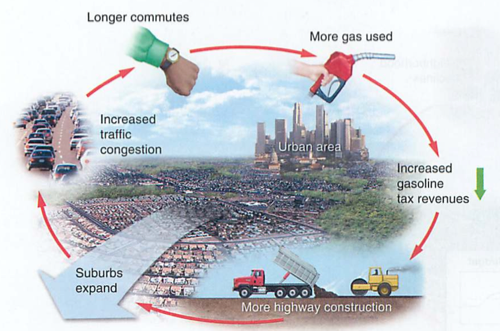
UGB (Urban Growth Boundary)-see PortlandPrevents Urban Sprawl (richer folks move to the suburbs, commute, need parking, city dies from the inside, food deserts, etc.)Portland Example of urban planning:Tom McCall Governor of Oregon, 1967-1975
Charlie Hales Mayor of Portland 2013-2017E2 video: Portland: Sense of Place....listen for Brad Pitt:http://physics.hpa.edu/physics/apenvsci/videos/e2_videos/e2%20transport/5%20Portland-sense%20of%20place.m4v
weblog withgott 6.6
e2: food miles
e2: Food miles
- Look up Michael Pollan: what books has he written?
- What is the fossil fuel to food ratio he cites?
- Why is this so high?
- What did it used to be?
- What does he mean by “sustainable agriculture”?
- Why did WWII give us a new form of agriculture?
- Look this up: in 1895, what portion of our workforce in our country was farmers? What is it today?
- Look up Lancaster PA, and who lives there?
- Local farmers may not be able to sell to Foodland and other grocery stores because of guarantees of supply. Where can the farmers then sell their produce, and what does this imply?
- When you go into Foodland and see the sandwiches and other wrapped foods, where were these prepared? Why? Why is this so nasty?
- Starbucks baked goods used to be baked here in Waimea (Mamane Bakery, behind the Montessori school). They are now baked on the mainland and shipped here frozen. Why does this make sense for Starbucks, and what impact does this have on you?
- McDonalds gets their food products from the mainland in huge truck and air shipments. Why do they do this?
- In the video, why is a restaurant that buys local food better than the examples above?
- Do you know of a restaurant here in Waimea that does this? What about our cafeteria?
- Why would Amish farmers be more sustainable farmers than other modern farmers?
- How many miles does the average food item travel in the video? Add 2500 miles for us, what is the new total?
- Why would they fly salmon to China and back?
- Local farmers can supply “food baskets” also known as a “CSA”. What are these and why are they more sustainable? https://en.wikipedia.org/wiki/Community-supported_agriculture
- Is “eating local” always a good thing? What are these folks known as?
- What is the difference between a solar and a fossil fuel food supply?
- What percentage of our income do we spend on our food? Is this the same in Hawaii? In Waimea? Why?
- Where does most of the cost of food go?
- Why do you think folks do not cook the way Pollan suggests?
- Contrast the amount of each dollar going to a farmer in the past and now. How does localization change this?
- Ok, now think of your home. What could you do differently?
Food: Modules 31-33
Weekend: Unit 4 ZipgradeNext week: review week, finals (using zipgrade forms)Modules 29 and 30 on land in JanuaryRecall our main themes: energy->water->food->culture
Food!Three main groups: Proteins: always include NitrogenCarbohydrates: CHO in chains (starches) or simple (sugars)Fats: CHO again, but in a special branch structure (glycol backbone) that is good for energy storage and insulation (e.g. killer whales, eskimos)
Proteins: complex molecules of CHO and N. Look up amino acids, note the common structure.Now look up the amino acid methionine. What element does it contain as well? Why do rotten eggs, swamps (and Kilauea volcano) stink?
CHO=carbohydrates (clever name), usually in a chain, short chains are sugars (used for fuel), longer ones are starches and can be used for structures (e.g. cellulose in plants) or pasta...smallest: sugars, all end in -ose (glucose, sucrose) LOOK THESE UP, CHECK OUT THEIR MOLECULE SHAPEglucose is a "monosaccharide" created by photosynthesis (next chapter)longer chains: starches (rice, pasta) slowly digested (see diabetics, and glycemic index)structural CHO: cellulose-little boxes with goo inside, need enzymes to break these down (cows)ENZYMES ALL END IN -ASE
Fats/lipids: same chemical structure as CHO, but built along a glycol (alcohol) backbone. If the fats have long carbon chains with only single bonds, they are saturated (lots of Hydrogen atoms) and can hold together (e.g. animal fat)https://en.wikipedia.org/wiki/Saturated_fat
If the long chains have double bonds and don't fit together, they melt easier (e.g. oils) and are called "unsaturated", usually better for your health.n.b. McDonalds® got into real hot water a while ago for frying all of their stuff in "supersaturated fats". Ugh...
Notes: Chapter 11 FR Overview:
- Frog 12.3 Agriculture
- Frog 12.4 Food Production
- Ch. 12 assessment
- FR ch. 11 feeding the world
- mod 31 nutritional needs
- mod 32 industrial ag-insecticides, GMO
- mod 33 sustainable farming
- Trophic pyramids in nature are sustainable
- Planet is nearing carrying capacity (K)
- Think of how many "earths" your global footprint represents
- To meet this food demand, current farming and fishing is industrial, not sustainable
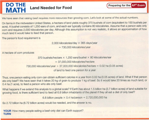
Food security: not just in lesser developed countries ("LDC"), also in the US"Food deserts"-what are these?Famine: one of these impacting a large group, often from crop failure, drought or war/displacementOvernutrition: common in the US, look up the US obesity rate-how is this determined? Why? Seen any food ads lately?Look up US obesity rate-----Meat diet: high in protein, also in fat (energy store) and cholesterol-these contribute to heart diseaseWait-Eskimos eat lots of blubber, why don't they have heart disease? How is this different from Kalahari bush tribes?ClimateWait, wait-what happened to Japanese health care system when they moved from their traditional diet?What impact does this have globally?Diet for a small planet 1971: planet can sustain population using fewer calories while supplying protein, vitamins and calories. Not by relying on meat.Vitamins="vital amines"Food energy subsidy (cost factor):20 kg of grain to produce 1 kg of beef (20:1 factor, or subsidy factor 20x)2.8 kg of grain to produce 1 kg of chicken (2.8:1 factor, or subsidy factor of 2.8)Better to eat beef, chicken, fish or tofu? (you need protein in some form)
Mod 32: Industrial Farming (and fishing)
Agribusiness: just what it sounds like, the larger conglomerates taking over instead of smaller privately owned family farms. Often use monoculture crops to increase profits (economy of scale), as well as patented seeds and herbicides (e.g. "roundup ready corn")
Hybrid crops vs. GMO crops:Started as a good thing: Hybrid crops"Selective breeding" works for animals (dogs, etc.) and crops called "hybrid crops" created by mixing pollen from one breed of plant (e.g. large kernel corn) with another breed of the same plant (e.g. short stalk corn) to form a "hybrid".
Green Revolution, Norman Borlaug-Mexican famine averted by development of hybrid (not GMO) wheat, called dwarf wheat (large kernel, short stalk).dwarf wheat
GMO crops:in the beginning were just to withstand frost, now into a larger patent issue with GMO seeds and "round up ready crops"What is the impact on lesser developed countries of this business model?
Genetically modified organisms (GMO) are different: they are done by splicing one part of a gene from an organism (like a frost resistant bacteria) into a totally different species (like a tomato) to make it frost resistant."IP" means intellectual propertyMonsanto spends money creating GMOs, so they patent the process, meaning using their seeds requires an IP license from them (just like software).If your farm has these seeds, intentionally or by accident, you have to pay them.You also cannot "re-use" seeds in the next season without paying for them.This is just like software in that you could buy the software or pay a monthly fee to use it.Which makes more money for the company?What is the impact on poorer countries?Roundup ready corn: seeds genetically modified to resist roundup (a herbicide)Result: plant their seeds, spray their herbicide and save money on weeding, more crops, more money (to whom?Issue: exposure to roundup (a carcinogen) and possible impacts of mutated foodLabeling? Where is this done so far?GMO from Food inc.
High Fructose Corn Syrup: HFCSCorn Lobby is very powerful (Iowa=presidential primaries)Corn: HFCS (food, meat, fish) and Corn Ethanol (energy, fuel)HFCS is in everythingCorn is used to feed cattle, pork, poultry, even fishCattle are not used to metabolizing corn, it makes them sickBad for humans, increases incidence of diabetesHFCS from Food inc.
Main problems:
- Irrigation-desertification
- Pesticides-persistent organic pollutants (POPs)-like in your water hunt
- Fertilizers-eutrophication
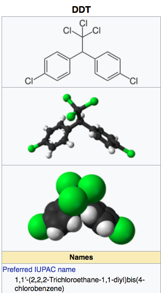
Pesticides and herbicides: can be persistent or not (DDT, round up)Invented during WWII to kill humans (nerve gases, nazis), ("homicides")Modified to kill pests ("pesticides") or insects ("insecticides")Special cases include rodent poisons ("rodenticides") and others, like plants ("herbicides")
Pesticide resistance-much like COVID: genetic variation in a rapidly multiplying pathogen will eventually overcome the stress (recall evolution) by replicating only those with immunity to the stress (vaccine, pesticide, drug resistant TB)
Here's one pesticide that changed malaria around the world: DDT:https://en.wikipedia.org/wiki/Dichlorodiphenyltrichloroethane
Fishing:Aquaculture means fish or other water animal farmed in the oceanHydroponics means growing plants in a water/air mediumFisheries: population of fish, look up Atlantic Cod fisheries collapse in 1990Bycatch: unnecessary death of animals caught in fishing nets/traps (dolphins, sharks, etc.)
Mod 33: Sustainable agriculture (fishing too)Desertification (see above)intercropping vs. monocropping, see "the three sisters"Contour cropping: saves space, reduces runoff, preserves top soil (e.g. our garden, most of Asia)No-till ag: same idea, retains organic material in topsoil, reduces erosion by wind and waterIPM: integrated pest management (see Lalamilo Farmers)Organic agriculture (also mentioned in Portlandia and Colin the Chicken)More than just N-P-K, also micronutrients, slower release time, low salinityCAFO: concentrated animal feed operation (e.g. chickens, pigs, cattle)Usually inorganic feed (purines), hormones and other drugs
Methyl xanthines: caffeine, theobromine, theophyllineevolved plant poisons for insects:
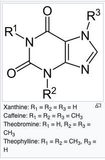
- Xanthine: group name
- Caffeine: energy drinks, coffee, soft drinks (to offset drowsiness from insulin spike)
- Theobromine: chocolate
- Theophylline: tea (also a bronchodilator-helps breathing)
- nicotine: tobacco
- caffeine: coffee, tea
- cocaine: coca plants
Poisoned Waters, part Deux
Poisoned Waters-Frontline Video
Video is here:
http://physics.hpa.edu/physics/apenvsci/videos/poisoned_waters/POISONED_WATERS.mp4
High quality version is here:
http://physics.hpa.edu/physics/apenvsci/videos/poisoned_waters/poisoned_waters.m4v
You may find it helpful to download this into your own computer: hold the option key while clicking on the link.
Context:
- Water Pollution-air pollution-climate change
- Watersheds, transit time
- water pollution:continuity, local until ocean,
Segments:
Segment 1: Chesapeake bay: 00-45:00
Segment 2: Potomac River: 45:00-54:00
- Chesapeake watershed
- EPA CWA 1970
- Perdue/hog Ag farms, Eutrophication
Segment 3: Puget Sound: 54:00-1:33:00
- Endocrine disrupters-drinking water
Segment 4: FairFax County, VA: 1:33:00-1:54:00
- Bioaccumulation-PCB Killer Whales
- Boeing-PCBs from runways
- Runoff-water transit time King County
- Tyson’s corner-transit time, sediment runoff
- Loudon county-traffic planning
- Arlington-urban planning
Questions:
Chesapeake Bay
- Why is it useful to get the historical view of the craggy old fishermen?
- How are the fish an indicator species?
- How large is the Chesapeake watershed?
- Why is this bay uniquely vulnerable?
- What causes dead zones in the film?
- What is the global trend in dead zones? where?
- What three basic functions of the bay will likely be lost to your generation?
- What was different 40 years ago?
- What was the cause and effect process of Earth Day and the EPA?
- Did Nixon back the clean water act? Explain.
- What were the key tenets of the CWA?
- What were the initial actions of the EPA?
- RFK jr. says he could not swim in the Hudson, Charles or Potomac. Where are these?
- Why did you have to take a shower if you fell into these rivers?
- What was the Potomac point source pollution source described in the film?
- What is BNR and how does it work?
- What is not removed from human wastewater with BNR that concerns us?
- How did Reagan’s policies impact the EPA and pollution regulation?
- What is “voluntary compliance” and did it work? explain.
Factory farms
- What is the biggest danger with concentrated animal farms/ CAFOs (poultry, pigs, cows)?
- Look up why we have different names for the same animals: cow/beef,chicken/poultry, pig/pork
- Why is it advantageous for Perdue to subcontract chicken operations?
- What is vertical integration?
- What was the national response to cheap chicken?
- If you were to put chicken manure on your garden, you could burn your plants. why?
- On the way downhill to the coast, there is an egg factory that went out of business, who now sells “manure compost”. Where did this come from, and how is it a good deal for them?
- Why does not Perdue own the chicken waste, if they own the chickens? How does the Perdue guy dodge the problem?
- What is the difference between city waste and ag waste?
- What does the chicken guy say about deer?
- What did the chicken lobby in Maryland (Eastern shore) do about pollution regulation? why?
- How is this similar to the Iowa corn ethanol lobby?
- RFK Jr. describes two things: externalized costs and subsidies. What does he mean by these?
Endocrine disrupters
- Why are not endocrine disrupters part of the clean water act?
- What is intersex in the male bass? what causes this?
- How does the concept of river continuity impact endocrine disrupters?
- Do they need to be very concentrated to be effective?
- A person flushes birth control pills (hormones) or other drugs down the drain. How can this impact someone living many miles downstream?
- Why are these hormones not filtered by water treatment plants?
- What is “synergism”? Why is it critical here?
Puget Sound
- How cold is the water in Puget Sound? Why is this relevant?
- Why do the apex predators have the highest concentration of PCB?
- What is a sentinel species? why is this relevant?
- Which population of humans is now showing similar health effects?
- What is Superfund, who funds it?
- What is the biggest liability problem with the Boeing dioxin situation?
- What is the concept of “deep pockets”?
- Why would native Americans be the indicator species in the Duomish river?
- Is South Park (not the tv show) upper income or lower, immigrant or not? Why is this important?
- On the AP exam, you will be expected to know all about Love Canal. How is this similar?
- What do you think is coming out of the pipe underwater in the video?
- Why are “impervious surfaces” so bad for the Puget Sound?
- Why do folks get upset about oceanic oil spills and not the stuff you see in the video?
- What is the difference in "transit time" for rain water hitting concrete vs. soil?
- Ron Sims has enemies in King county. Who?
- How is the Growth Management Act/Critical Areas Ordinance (CAO) similar to the Urban Growth Boundaries (UGB) concept in Portland Oregon (we'll see this in the Portland e2 video)
- Look up the CAO now. How is it going?
Fairfax
- Look up Tyson’s corner. What did it look like in 1945?
- Would Tyson’s corner have been successful without cars?
- How is Tyson’s corner like Los Angeles?
- How is Arlington different from Tyson’s corner?
- In a sense, US cities are learning to become more like older European cities. Why are they different?
- What is the meaning of the phrase “canary in the coal mine” and where did this term come from?
- According to the narrator and Governor of Washington, what is a necessary part of the solution?
- What is your part in this future?
2. From the Poisoned Waters Frontline video, choose one of the stories and explain why it is important to you, what it explained, and how it relates to your work.
Modules 26-28 Water ch. 9
Recall:
Water: key points
Section one: What is it, where is it:
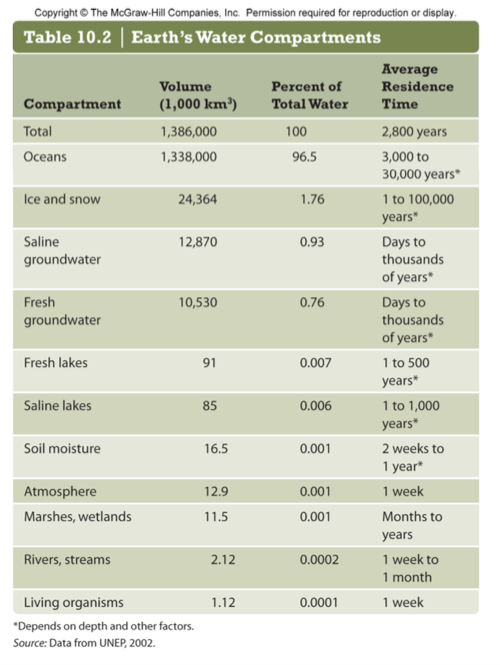
Freshwater, saltwater, how it moves, aquifers and reservoirs, impact of climate change, water wars
Section two: Pollution:
Often human driven (anthropogenic): Nutrient, thermal, BOD, sediment
Almost always human driven: Pathogens, inorganic chemicals, organic chemicals, radioactive chemicals
Section three: Water Quality index:
DO, BOD, pH, temp, turbidity, conductivity, nitrates (NO3), phosphates (PO4)
Section one: What is it, where is it?
Where is the water? Note: 97% salt water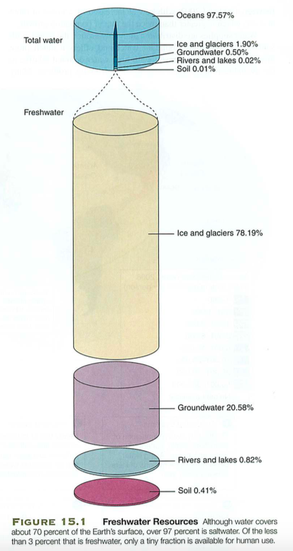
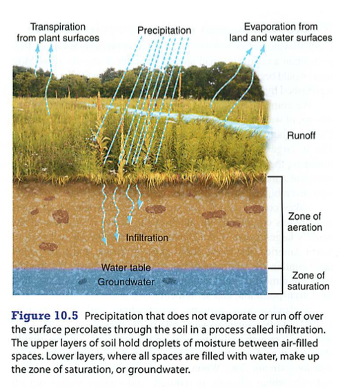
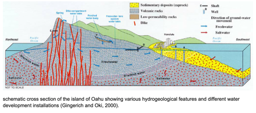
Aquifers: open or closed ("captive")

Huge Ogallala aquifer-note recharge time is in centuries, pesticides in Nebraska, cancer rates there are very high...


- Pearl river delta and salt intrusion (sea level rise): gradual slope, so 1 meter of sea-level rise is many km of salt intrusion, so no more rice farming in that area
- Vanishing Himalayan Glaciers: no farming in western China, no annual flow through their two main rivers
Glaciers are the "water towers" for all of Asia...Rivers impacted:Ganges, Yangtze, Yellow, Mekong, Brahmaputra, Irrawaddy, Indu, Salween,
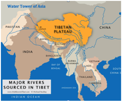
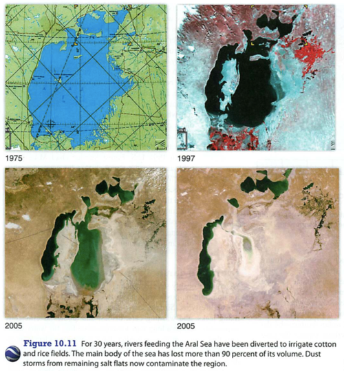
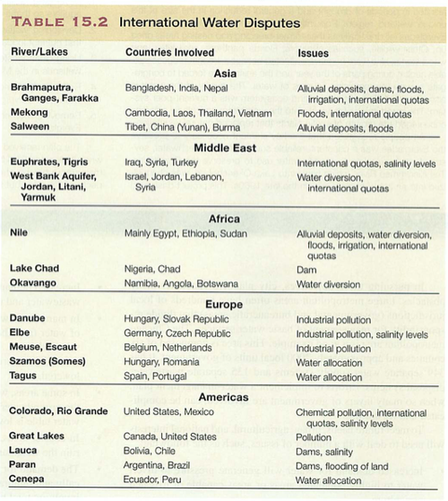
Section two: Water PollutionBig ideas:
- Rivers are continuous, so easier to find sources along the route (continuity analysis: all sources add to total)
- Groundwater is harder to determine point sources, as flow is over larger area (not confined by river banks) and there is no continuity analysis possible (we don't know sources and sinks)
- Oceans are the hardest to trace, and impact everyone eventually, just like the atmosphere, only without the rain, and it is wetter. And full of fish.
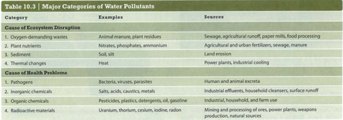
Water Pollutant list: Common culprits
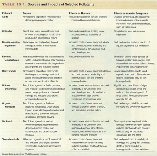
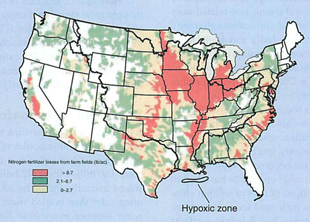
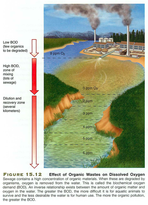
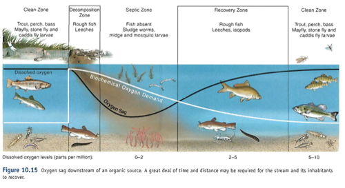
Note that temperature changes DO (dissolved oxygen) content, so does physical agitation (aeration).Section three: Water Quality Index:
http://www.water-research.net/watrqualindex/index.htm
Calculation worksheet:
http://www.pathfinderscience.net/stream/forms/WQI_worksheet.pdf
Main case studies-each related to a form of human pollution:Case 1: High turbidityCauses: erosion of topsoils, till farming, no cover crops, e.g. dustbowl in the USImpact: poor light transmission, so low photosynthesis, low DO
Case 2: Low Dissolved Oxygen (DO)Causes: Thermal pollution, e.g. power plants on rivers
Case 3: Eutrophication (high N and/or P)Causes: Fertilizers, animal waste, e.g. Mississippi dead zone, Chesapeake bay
Chesapeake bay is the perfect storm of these three: 1. Warm water: shallow, so no cool lower zone away from sunlight, dissolved solids turn visible light into heat2. High Turbidity: watershed runoff from rivers to the Appalachian range and north to NY state3. Eutrophication: chicken and pig farms, runoff from farms along watershed
See also point source and non-point source pollution (from Poisoned Waters video, remember the Deer?)
Important: cooler water holds dissolved oxygen better (fishermen know this, so do the fish).
Water Quality Lab:
Tests: Probe sets
- Turbidity sensor: passes light through a small vial, measures light that passes, low light=high turbidity
- Conductivity: passes electric current through sample, proportional to salt content
- Temperature: warmer water has lower DO
- Dissolved Oxygen: amount of oxygen dissolved in the sample
- pH: acid/base tendency
Tests: dip strips:
- Alkalinity
- pH
- Hardness (calcium/mineral content)
- Iron
- Copper
- Lead
- Nitrate
- Nitrite
- Chlorine
Lab samples
- Post waterfall
- Post power plant
- Everglades close to ocean
- Post sewage plant
- Best fishing spot
- Mine tailings runoff
- Snow melt river
- Mississippi river
- Chesapeake river
- Flood after monsoon rains
- Golf course runoff
- Eutrophied lake
- DO
- BOD
- pH
- temperature
- turbidity
- conductivity
- nitrates
- phosphates
- DO:1.5
- BOD:low
- pH:7
- temperature:30°C
- turbidity:high
- conductivity:low
- nitrates:high
- phosphates:high
- DO:6
- BOD:low
- pH:7
- temperature:10°C
- turbidity-low
- conductivity-low
- nitrates-low
- phosphates-low
- DO: 4
- BOD:low
- pH:8
- temperature:25°C
- turbidity: high
- conductivity: high
- nitrates: high
- phosphates: high
- DO: 2
- BOD: high
- pH:5
- temperature: 28°C
- turbidity:high
- conductivity: low
- nitrates: low
- phosphates: high
- DO: 2
- BOD:low
- pH:2
- temperature:20°C
- turbidity:high
- conductivity: high
- nitrates: low
- phosphates: low
- DO: 1
- BOD: high
- pH: 4
- temperature: 30°C
- turbidity: high
- conductivity: high
- nitrates: high
- phosphates: high
Soils Lab
- visual inspection (color, grain size)
- manual inspection (tilth, moisture content)
- soil size percentages (sifting test)
- pH
- N: Nitrogen
- P: Phosphorus
- K: Potassium (Kalium)
Lab Format
Title: what the lab is about
Background: some information to give context to your reader
Purpose: what you hope to study
Materials: everything needed for the experiment
Procedure: what you do with these things to study the purpose
Data: any numbers, charts, tables or information using numbers
Observations: anything not explained by your numbers above
Error Analysis (optional, but required in college): what went wrong, possible reasons or explanations, when proving something or synthesizing something, what is your yield, percent error, and why
Conclusions: think back to your purpose-what did you discover, how would you improve upon this in the future, what lessons could be shared with others?
Example:
Title: Making Chocolate chip cookies
Background: Home made chocolate cookies are the best, so making them at home is a necessary skill
Purpose: To make chocolate chip cookies at home
Materials: flour, sugar, butter, sugar, vanilla, sugar, chocolate chips (nuts optional, but yucky)
Procedure: Pre-heat oven to 550°F, mix ingredients, test for taste, put blobs on greased cookie sheet and bake for 45 minutes.
Data: 12 totally burned cookies, 25 grams each
Observations: cookies were burnt to a crisp, inedible and quite stinky
Error analysis: temperature was too high, baking time was too long
Conclusions: next time we try this, we should reduce temp and cooking time
Modules 24-25 earth and soils
Module 24: Earth ScienceKey points:- All elements up to Iron on the periodic table came from the big bang
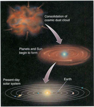
- Earth was formed from materials created by first generation stars going supernova
- The core of the earth is made up of a rotating solid core surrounded by a liquid core
- The inner core creates our magnetic field, which reverses periodically
- Layers: crust-mantle-outer core-inner core
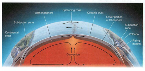
- Uranium in the core produces heat that travels to the surface by convection
- Tectonic plates on the surface move on top of the sticky asthenosphere because of this convection
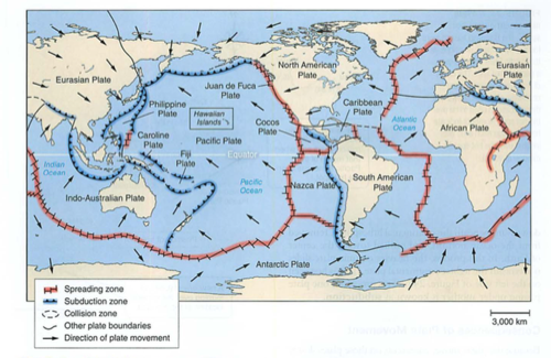
- Spreading zones are were these plates are created, subduction zones are where they dive under others
- Subduction zones create trenches in the ocean and andesitic volcanoes (sticky lava, pointy cones)
- Hot spots in the crust can create basaltic volcanic islands like the one we are on (runny lava, broad cones)
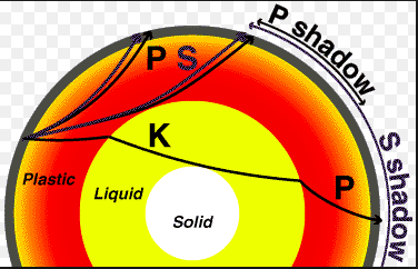
- Earthquakes include P (primary, compression) waves and S (secondary, shear) waves
- P waves are faster and go through solids and liquids, S waves only travel through solids
Why?Well, if we know what asteroids are made of, we have a clue about what materials (e.g. water) that were around when the solar system formed.From this info, we can look for those elements in other solar systems, and look for life there.Back to our earth...
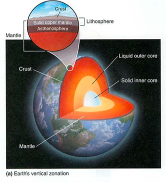
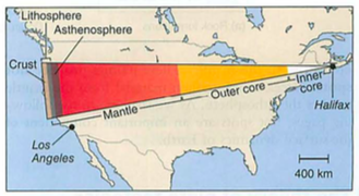
The core is actually two bits: solid inner iron and nickel, liquid outside that bit. It spins, giving us a weak magnetic field which switches direction every few thousand years. Remember this, it comes up later...How do we know this? Nuclear bomb testing and our global seismic sensor network.How?Two key clues about the earth came from military conflict: one from WWII and another from the cold war, when everyone was building bigger and bigger bombs.First the cold war part:We set up seismic sensors called seismographs all over the world to spy on Russian and Chinese nuclear ("A-Bomb", fission) and thermonuclear ("H-Bomb", Fusion) bomb testing to see how powerful they were.You next need to know that there are two main types of earthquake wave: P or "primary" waves which are compression waves. and S waves "secondary waves" that are transverse, like shaking a slinky.P waves are faster, and go through solids or liquids, but at slightly different velocities.S waves are slower, and can only travel through solids.So,Here's what they saw:
Now, to the WWII part...Submarines like to hide underwater, so planes and ships can't find them.So, during WWII, our side tried dragging little magnetic sensing torpedo thingys from behind their ships, hoping to detect submarines. (they later used airplanes too).Here's what they found:What the heck is this?
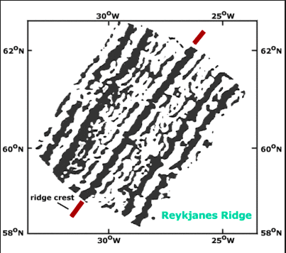
This might help:

Ok, let's break this down: between England and the US, they found stripes of North then South weak magnetic fields.When they got to the middle of the Atlantic (about where Iceland is on the map above), the pattern reversed.Huh?That's what they said too...Remember the shifting magnetic field every few thousand years?As the magma came out of the earth in the molten state, it solidified in the magnetic field of that time, so the newest lava was along the center of the ocean (under Iceland too).
Ok, now shift quickly to a meteorologist named Alfred Wegener. Meteorologist is a fancy name for a person who studies the weather.He cut out the continents on a map (like, with scissors) and noticed that South America and Africa fit nicely together. Try this on your globe----Everyone in the geology community told him he was nuts.He later froze to death in Greenland, but I digress...
Then, these strange magnetic stripe thingys showed up from the ships dragging those magnetic torpedoes....and it proved he was RIGHT:Remember how hot is was in the earth core?That heat rises to the surface as magma (say like Dr. Evil), just like the Hadley, Ferrel and Polar cells do:
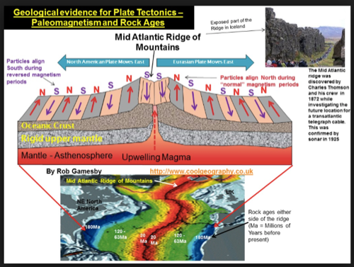
Remember the earth's magnetic field changing?
Check out this diagram: note the red (spreading) and the blue (subducting), esp. look at Chile---->
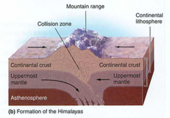
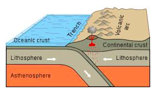
Let's review the geological players:Magma-(Dr. Evil voice here: https://www.youtube.com/watch?v=yVo1S52xdpI)Asthenosphere-"sticky rock" (from Greek ἀσθενής asthenḗs 'weak' + "sphere")Lithosphere-floating rock (litho = stone) (Ancient Greek: λίθος [lithos] for "rocky", and σφαίρα [sphaira] for "sphere")Continents-even more floaty, made of lighter rock (granite) that formed from the interaction of magma with oceans
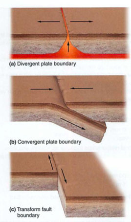
Plates are large, float on the AsthenosphereContinents are like rafts on the Asthenosphere, more buoyant than the platesThe plates can slide under each other (subduction zones), crash into each other (Himalayas), next to each other (transform faults), and are formed at spreading zones (divergent boundaries)
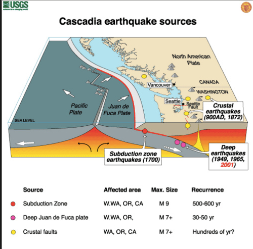
Neato. What about those earthquakes?Check this out:
 |
| Click for a full-size image |
Two things to take-away about subduction zones:1. subduction zones create ANDESITIC (pointy) volcanoes, which are high in silica, and sticky like thick pancake batter.2. subduction zones create lots of deep-focus earthquakes.
We are lucky enough to live on an island with several active or dormant volcanoes. We live on top of a "hot-spot":
Hot spots:Usually in the middle of an oceanic plate, but can also be mid-continent (e.g. Yellowstone supervolcano caldera)Hot spots-basalt-low silica content which melts easier (e.g. look out the window)
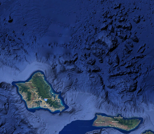
Look at the Hawaii island chain on google earth (underwater version)While you are at it, look for the Nuuanu landslide that created a 4000' tsunamiYou can also look at the Mauna Loa simulated tsunami on youtube...
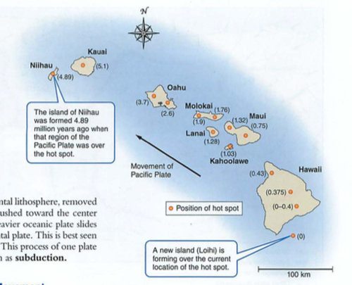
Note the tracking of the pacific plate:
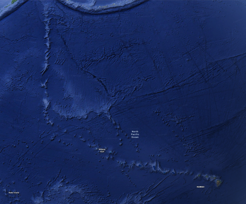
This is what happens to a shield volcano when it "calves" one side, in this case, the northeast side, in the Nuuanu landslide, one of the largest landslides on earth, causing a tsunami that deposited coral on the top of Mt. Kaala, 4055 ft. high...
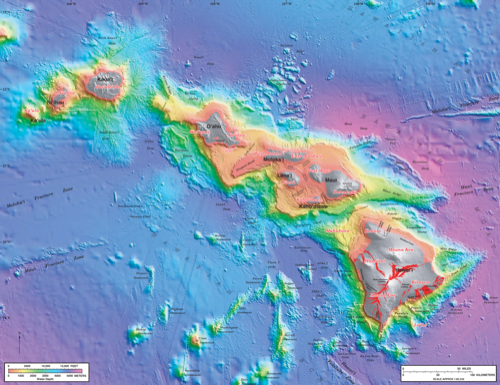
More about earthquakes:
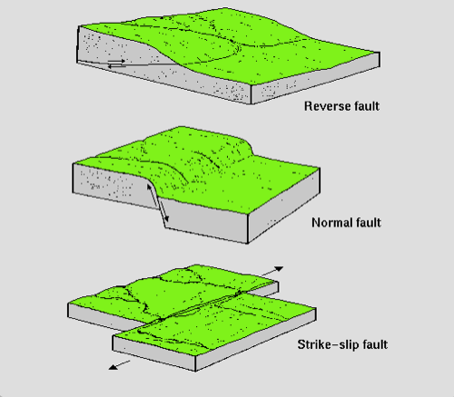
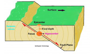
How do we find these?Seismographs:P waves travel by compression (comPression). These are longitudinal waves, like sound. They can travel through liquid or solid.S waves travel by shear (Shear). These are transverse waves, like a slinky. They can only travel through solids.Remember this?
Ok, back to earthquakes.Suppose you have a house on posts (called "post and pier" construction). An earthquake happens some distance away. First, your house moves back and forth (P wave, much faster at 8 km/sec). After a time, your house bounces up and down from the S waves (slower at 3 km/second).If you are far away, these are separated by different arrival times.If you are near the epicenter, they hit at the same time...up, over, down=your house is demolished
We use this difference to calculate distance from the epicenter (and hypocenter if you are interested) using delay times on the seismograph
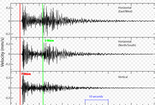
Look at the HPA seismograph here:http://www.fdsn.org/networks/detail/PT/
and our Hawaii quakes here:https://volcanoes.usgs.gov/observatories/hvo/hvo_earthquakes.html
Click on some earthquakes and note the depth and the seismic image.
Next: Rocks Module 25Igneous (fire)Sedimentary (layers)Metamorphic (Kafka rocks, just kidding: changed by heat and pressure)
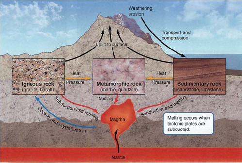
Igneous= directly from magma, and can be either basalt (low melting point, like our island or oceanic plates) or granite (lighter, what continents are made of)Granite breaks down into light-colored sand, makes for fertile soil. Basalt (like us) can make sand too, but less fertile (e.g. black sand beach).
Sedimentary= just like it sounds, from mud, sand, or dust, usually in layers.
Metamorphic= changed by heat and/or pressure (slate, marble, or coal)
Soil-formed by weathering (chemical or physical) of parent rockErosion can be by water or air (wind)
Soil Horizons:
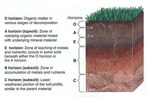
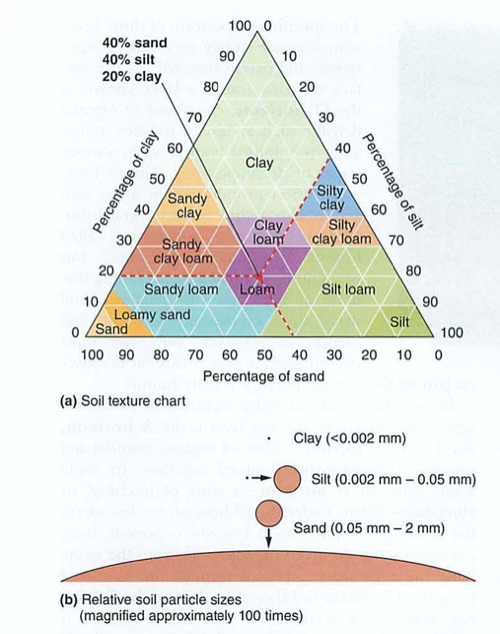
Our Soil Sieve has 4 filters, with 5 layers:mesh 5 = 4 mmmesh 10 = 2 mmmesh 60 = .25 mmmesh 230 = 0.063 mm
Basically, most of what you find is silt and clay...
Populations Mods 23-24
First of all a flow diagram: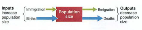
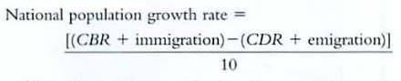
If you look at the planet as a whole (sans aliens or Elon Musk):

so, there is a neat shorthand formula for this:
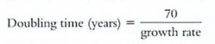
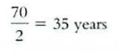
Note that as the growth rate increases, the doubling time decreases.Look for this on the AP as multiples/fractions of 70: 14, 28, 35, and so on...
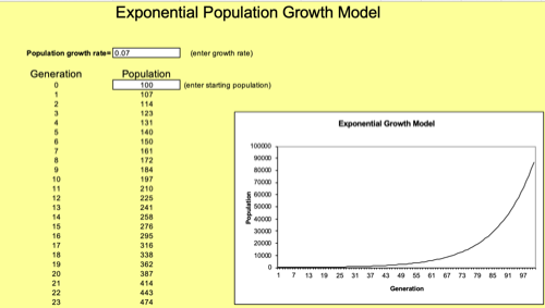
You can also see this by using our previous formula: Nt = Noe^rtSet N to 100, try with a 7% growth rate (0.07 is r) and set time to be 10 years (70/10)Calculate NtHere's what this might look like:
Now, to babies: TFR is the total number of babies a woman will have in her lifetime.Replacement level fertility (RLF) is just above 2.0, (usually 2.1, as some babies don't reproduce or make it to reproductive age).What does this mean in Japan, where young people are not having babies?
RLF depends on developed/developing nations as well (clean water, medical care, access to food, war)Life expectancy: depends on these as well...Infant mortality: under age 1 (reason for big Hawaiian one year birthdays)child mortality: under 5
Look up life expectancy in 1900...Look up the average family size and how many made it to age of 5 in 1900What portion of the US population was farmers then?
Age structure diagrams/population pyramids-check these out: UAE, Japan, Sudan, Iraq/Iran, Russia----WHY?See also baby boom and boom echoes...Check this out:https://www.populationpyramid.net/world/2021/
...and look these up:
- Go to 1950 and look at the US population. Look again in 1960. Where is the baby boom? Why were there so few babies born during 1940-45?
- If you were a 42 year old American in 2000, when were you born? How old are your kids? Find the "boom echo".
- Find the impact of the Iran/Iraq war of 1980-89, which side had the biggest impact? If you were a 35 year old Iraqi man in 1995, how old were you during this war?
- If you are a 30 year old German man in 1950, when were you born? How old were you in WWII (1936-1945)?
- If you were a 35 year old woman in Japan in 1960, why are there so few men to choose from?
- Look at the UK in 1960. Where are the casualties of WWII, and are they both male and female? Explain.
- What the heck is going on in UAE?
- Look at Russia in 1960. What gaps do you see? Why?
- Information about China is very spotty-why would this be? See if you can find the impact of the one-child policy from 1979-2021.
- Compare present day Japan to Africa. What issues will they need to address?
- Look at present day Italy, Japan and Germany. What is common?
- Compare present day India and China. What do you see?
Terms to know: Human Populations-----------------------------
Fecundity: the ability to reproduce
Fertility: production of offspring
CBR: crude birth rate: births per 1000 people
TFR: total fertility rate: total kids per woman in her lifetime (25-30!)
ZPG: zero population growth: 5+ where infant mortality is high, 2.1 is normal
China: was 6 -> 1.8 (below replacement level since 1979, one child policy)
China has a 140/100 male to female ratio: why?
Global TFR is 2.6
CDR: crude death rate: deaths per 1000
Why is there a life span? mitochondrial DNA...
1900 Indian man had life expectancy of 23! Trace this to now...
Not now, reasons: nutrition CLEAN WATER, sanitation, education
75 men, 85 women (testosterone, war, "hold my beer and watch this!", Darwin Awards)
Dependency ratio; baby boomers and your future: how many workers to retirees
imagine your life at your age in other countries...
Russia low TFR: alcoholism and antibiotic resistant Tuberculosis
Module 23 Demographic Transition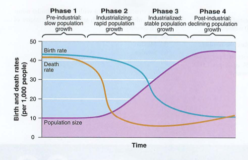

Things to notice:1. in phase 1, lots of babies, lots of death (infant mortality and short lifespans), so population is low 2. as clean water, sanitation and health care improve, deaths drop, so population rises3. as women gain reproductive rights and/or education, the birth rate drops (many factors here), while death rate stays low, so the population growth curve flattens a bit (hard to see on this diagram)4. as industrialization includes more women, esp. as professionals, they may delay pregnancy later in life, so there is actually a population drop. Examples are Italy, Japan and Germany, where the dependency ratio (number of people depending on social retirement divided by number of people in the workforce paying into the system) is greater than 1.0.
Make sure you can cite at least one example country for each...1. Sub-Saharan Africa, most of the world before the industrial revolution2. Afghanistan3. US4. Japan
Another view:

IPAT formula:

IPAT: the impact on an ecosystem = population x affluence x technology
Why is Apple using a robot ("Daisy") to take apart iPhones? How does this impact iPAT?https://www.apple.com/newsroom/2018/04/apple-adds-earth-day-donations-to-trade-in-and-recycling-program/
Which parts of the iPAT formula does this impact, and in which ways?
Think also of electric vehicles: great for the environment, but use materials (Lithium, Neodymium, etc.) that need to be mined. Gasoline/Diesel cars need steel, glass, plastic and some rare materials for electronics, but are much worse for the environment, both in production, use and disposal. More on this later.-------------------https://www.gapminder.org/tools/#$chart-type=bubbles&url=v1
https://www.ted.com/talks/hans_rosling_on_global_population_growth--------------------GDP vs. GNP (nationalism, global economy)GDP is global domestic product, or the sum of all goods and services delivered inside a countryThis was the standard growth metric until recently...GNP is the same thing, but includes multinational companies, or companies "off shore"
Urban areas, UGB (Portland)

See also Ecological Footprint Calculator:
http://www.footprintnetwork.org/resources/footprint-calculator/
https://www.ted.com/talks/hans_rosling_shows_the_best_stats_you_ve_ever_seen(9 minutes)
Play with these:
https://www.gapminder.org/https://www.gapminder.org/tools/#$chart-type=bubbles&url=v1
Rule of 70, er 69.3...The TRUTH!We know that Nt =Noe^rtWhen Nt/No = 2, this is the doubling timeln (Nt/No) = ln (e^rt)ln(e^x) = x just like square root of x squared is x. They are reverse of each other...ln (2) = 0.693 = rtSo...0.693/r = t2, the "doubling time"But wait! we saw 70, not .693...Growth rates are in percent (part/100) so the percents cancel out, meaning you can just use percent as a number, like 14%.You will certainly see this on an AP exam, usually as a multiple or fraction of 70: 14, 28, 35, 7, 3.5...Rule of 70 rules! (or actually the rule of 69.3)....
Next: earth and soils:https://www.youtube.com/watch?v=xzAOhyOtfqc
Mod 18-21 Population Ecology
See also chapter 5 in Withgott: Evolution, species interaction, communities and species interactionsLab: Predator prey phase delayModule 18-abundance and distributionStart with this: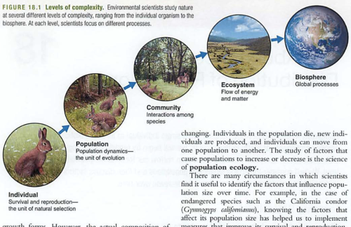
or:some rabbit individualsome of the rabbit's friends, a population of rabbitsrabbits and the things they eat and eat them-communityecosystem-the plants that support both ends of this processbiosphere-the planet
We covered ecosystem energy and matter a few weeks ago, this chapter is about population ecology.
Notation: Population size is represented as N (note not "n"): population size within a defined area at a specific time (brings in migration).So, we could say the student population of HPA would be all students here this year, 2020-2021
Check out the diagrams on population distribution: random, uniform and clumped. Important vis a vis biodiversityStructures: age and gender (sex)
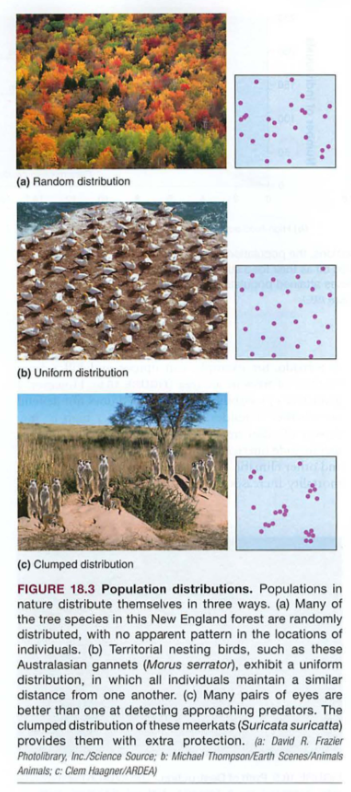
Density dependent factor: e.g. food or reproductive rate in rats (more rats, lower fecundity)Something that influences reproduction or survival...
Density independent factors: storms, disasters, fires (note density independent: one bambi or 100 bambi all perish in the same fire)
Limiting resource: usually food, but could include space, nutrients, etc.
Carrying capacity: K (note not "k"): how many individuals an environment can support
Module 19: growth modelsImagine you are a happy bacteria, or rabbit, with lots of food, land and no predators. Your population growth curve might look like this:
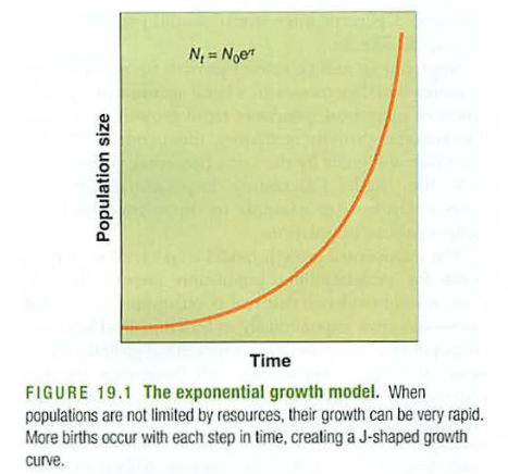
This is called exponential growth, or "J shaped growth"Note that it has no end, or limiting factor.
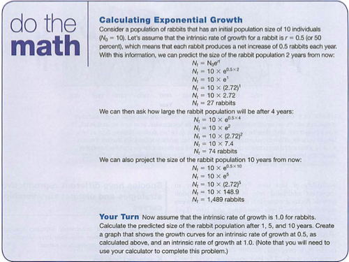
Small r is the growth rate. If you have had physics (yay!) this is usually "k" in some examples, or related to RC decay/growth.Learning this equation is VERY useful.Note that it depends on two things: the starting amount in the population (No) and the growth rate (r)Here is an example:
You might also find this link useful:https://www.khanacademy.org/science/ap-biology/ecology-ap/population-ecology-ap/a/exponential-logistic-growth
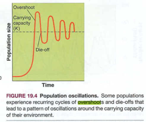
Many systems follow J shaped exponential growth until they run out of food or space, then there is overshoot and die-off:
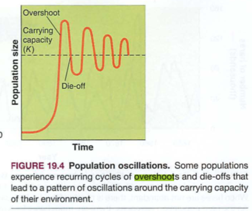
A more ideal version of this is the S shaped curve, called logistic growth:
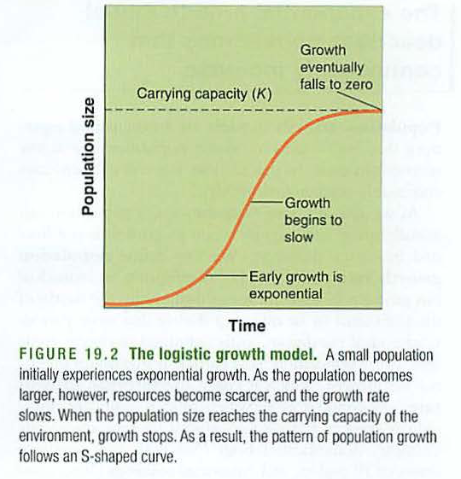
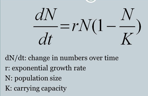
Here is a formula for logistic growth that we'll discuss:
------
Logistic growth worksheet
First: exponential growth:
Imagine 10 imaginary rabbits (No=10)
Assume r = 0.5 (50 percent growth rate, or each rabbit makes 0.5 rabbits per year)
Find the population 2 years later:
Nt = Noe^rt
Nt = 10e^0.5*2
Nt = 27 rabbits
After 4 years:
After 10 years:
———
Next, use the logistic growth formula, same data, with a carrying capacity (K) of 100:
Small population: 10 rabbits
∆N/∆t = rN(1-N/K)
= 0.5*10(1-10/100)
= 5(1-0.1)
= 5(0.9)
= 4.5 rabbits per year
Find the rabbits per year for these populations:
Medium population: 27 rabbits
Near K: 74 rabbits
Above K: 1489 rabbits
quiz (you may use your worksheet only)
- 30 rabbits live on an island with carrying capacity 200. They reproduce at a rate of 0.5 per year. How many rabbits will be on the island after 3 years? (hint: you would do the calculation three times-this is only an estimate though, the true formula would be a bit more complex)
- What will be the slope of the growth curve at this point?
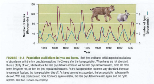
Predator Prey Lab:

Worksheet: (uses Numbers application)

Worksheet: excel version:

Questions:

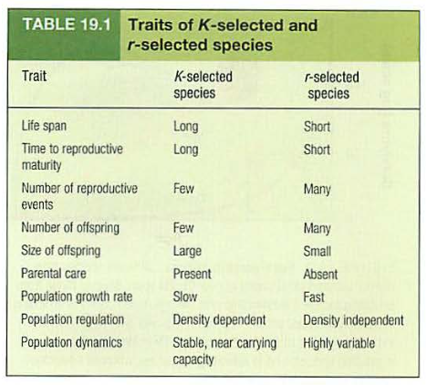
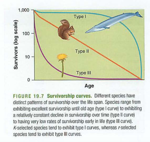
Now we can discuss generalizations of r and K strategists:Note: r comes from small r (growth rate) in the growth formula, while K comes from large K in the same formula (carrying capacity):
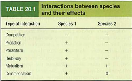
Module 20: Community ecologyCompetitive exclusion principle: two species competing for the same resources cannot co-exist, leads to...Resource partitioning: time, space, type of food (one species picks one, the other survives)Relationships:Predation: predator and prey, one lives, the other diesSymbiotic:Mutualism: both benefitCommensalism: one benefits, no harm to the otherNon-symbiotic:Parasitism: one benefits, harm to other
keystone species vs. indicator species
Keystone species-many others depend on it, removal has an impact much greater than their relative population
e.g. beavers: create habitat for others (dams), so they are also "keystone engineers", only they don't wear funny hats.
Here's what a keystone looks like:
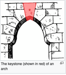
In architecture, if you remove the keystone, the arch collapses. Cool term, right?
This is different from a capstone (seniors might like this): a capstone is what you put on top of a finished structure
Another example: "keystone predators" e.g. sea stars, which eat mussels, clearing space on rocks for other species
Indicator species-signal health of a system, like some fish or worms signify water quality, also known as "bioindicators"
Succession: one species takes over another in time
Module 21: Community Succession
Primary succession: From bare rock, no soil: (e.g. lichen)
These hold moisture and some sort of matrix (e.g. soil) so that others can then grow
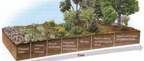
Secondary succession: from disturbed area with soil (e.g. after a fire)-there is soil, but no plants, growth here might be quicker than primary sucession.
Pioneer species: arrives first, sets up reliable system of water and matrix
Climax community: stable, well evolved ecosystem, e.g. old growth forest, able to survive disasters (e.g. fire)
Aquatic succession: from stream (flowing water) to pond (less flow) to shallow pond (even less flow) to marsh (mostly mud)
Island biogeography (like here in Waimea): habitat size AND distance from others influences diversity (e.g. birds)
This was Darwin's whole gig, also some folks off the coast of Chile, often with birds involved.
Check out an alternate presentation of these in the Withgott text, with a special section about our island:
http://physics.hpa.edu/physics/apenvsci/texts/withgott/withgott%206e/3-4.pdf
Frog book chapter 5:

Questions:
- What three things in order are necessary for evolution to succeed?
- What are the characteristics of an r specific species. Give an example.
- What are the characteristics of a K specific species. Give an example as well.
- The population of wolves may rise and fall along with rabbits, but not at the same time. Explain why.


Mods 14-17 Biodiversity
Sunday Earthquakes 4.3 and 6.2https://www.usgs.gov/observatories/hawaiian-volcano-observatory/earthquakes

Northern Lights over Scotland: space weather.com
CME event: coronal mass ejectionhttps://en.wikipedia.org/wiki/Coronal_mass_ejection
------------------------------Mod 14: Biodiversity: (see also chapter 7 in Froggie book)
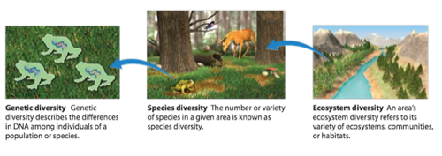
Genotype: set of genes (dominant and recessive)Phenotype: traits expressed in a living creature
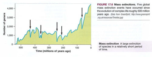
Genetic drift-pretty much what it sounds likeBottleneck effect-VERY important: when a species is almost extinct, there is little variation in the gene pool of the survivors, even if their population rebounds (e.g. whales hunted almost to extinction, the entire gene pool is limited to the diversity of the sole survivors)Founder effect: random selection of survivors, creating a new gene pool (birds, gilligan)
Questions:1. If the early atmosphere of our planet was thinner and less developed, it might have allowed more cosmic radiation to reach the surface. How would this impact the natural mutation/evolution rate?2. what would be the impact on an ecosystem of rampant mutation rates?
Mod 16: speciationGeographic isolation (e.g. Galapagos) also found where we disturb natural habitats with roadsThis causes Allo (other) Patric (father) speciationEventually reproductive isolation will result: different breeds will not be able to procreate
There is another more rare form of speciation: Sympatric ("same father"), from polyploidy, ("many chromosomes")
GMO: see roundup ready corn and wheat, freeze proof tomatoes and others.Not to be confused with Dwarf Wheat and Norman Borlaug (see population chapters for more on this).Dwarf wheat was a simple hybrid, not a GMO.Look up "gene guns" and CRISPR
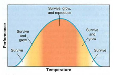
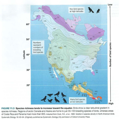
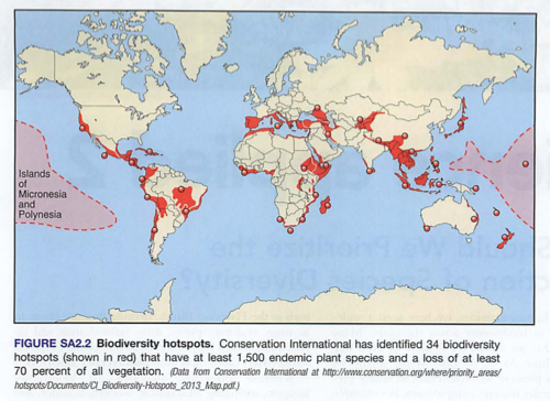
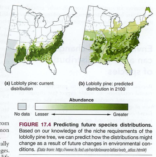
Mod 17: niches and species distributionCheck this out:
Global warming and biodiversity:
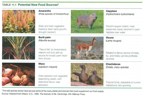
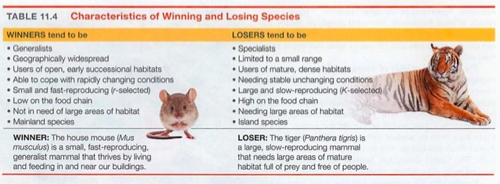
Alternates to low biodiversity food sources (e.g. monoculture):
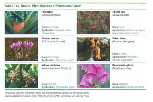
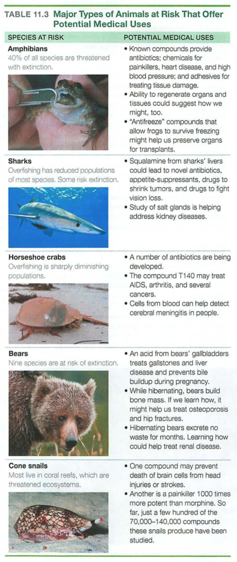

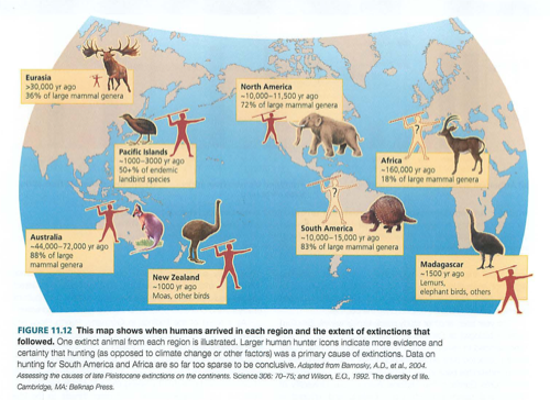
Past human impact:

Delete this content
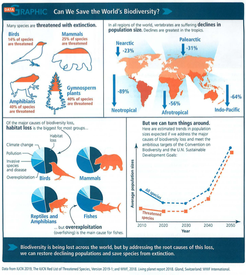
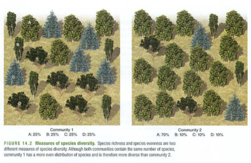
We can calculate biodiversity:
Delete this content
: Calculating Shannon's index, using baked goldfish (the cheddar kind, not the ones that stink):
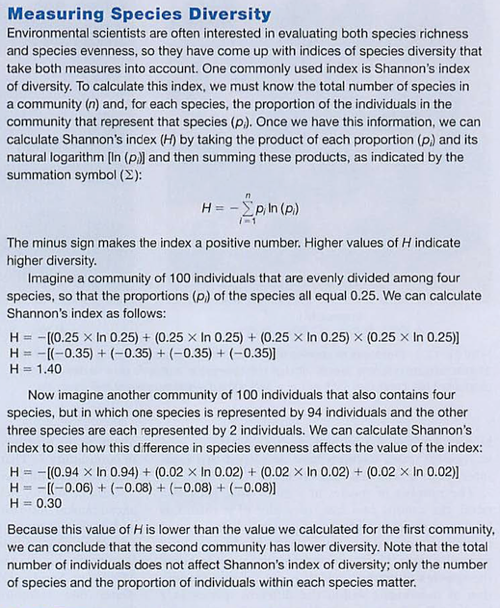
Labwash your handspour out a random number of different colored goldfish on your plate (your "pond")determine the number of distinct populations by color, using chopsticksdetermine the proportion for each population (e.g. 5 red ones out of 20 total would be 5/20 or 0.25)calculate Shannon's index (H) for this "pond"repeat the experiment with a very low biodiversity, calculate Hrepeat with a very high biodiversity, calculate Heat the contents of your "pond", representing a catastrophic eventQuestionswhat is the value of biodiversity in any community?what are the benefits and drawbacks of a low biodiversity?how does this play into competition (next chapter)why is it important to determine the number of "distinct populations"?what is the impact of this on a human population, e.g. the census?
Check-in review:Unit 2 from Cliff notes 2011: Delete this content
Unit 2 practice exam p. 190-----NEXT: Population ecology-----------

Delete this content
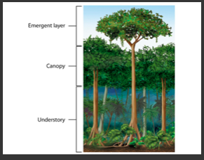
tropical rain forest-canopy (layers)--------
Delete this content
tropical dry forest——
savanna——
desert——
temperate forest——
temperate (mild) grassland——
chaparral——
Boreal (north) forest———
tundra——
polar ice—
mountains—
Delete this content
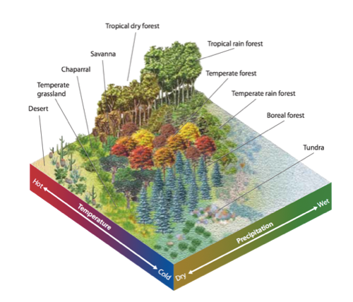
Recall terrestrial biomes are defined by temperature and precipitation (rain)Aquatic biomes are by definition underwater, so they are defined by We separate aquatic biomes into freshwater (lakes, rivers, streams) and saltwater (oceans, estuaries):Riparian=riverLimnotic=lakes:Shallow shore area=littoral (means shallow), see the "littoral Navy", photosynthesis here (shallow, light shines through)Open water area=limnetic zone, no rooted plants (too deep), phytoplankton here, only as deep as sunlight can penetrateDeep water=profundal ("profound") or deep zone: no light penetrates, bacterial decomposition.Bottom=benthic zone: mud, dark, cloudy
aquatic ecosystems—
oceans——
0 commentsadminMod 13 Aquatic BiomesDepth: how deep is the deepest part, how much photosynthesis is possibleDistance from shore: shallow water has more life, more things to attach to, more biodiversity
Freshwater biomesLakes
Delete this content
: note usually related to photosynthesis (plants)Oligo (few) trophic=low productivityMeso (middle) trophic=mediumEutrophic (eu=good trephien=food)=lots of productivity (sometimes too much, like in "Poisoned Waters")Freshwater wetlands-submerged most of the time (swamps, marshes, bogs) this is the history of all coal and oil we now use usually connected to the sea, act as a coastal buffer for Hurricanes, very productive, many nutrients, lots of organic materialp: special version of this in Tropical areas (e.g. Florida) area between high and low tide or seasonal variationsCoral reefs-see coral bleaching, pH, temperature and salinity sensitive (see Hamakua coast vs. Puako)Intertidal zone: between high and low tidePhotic (light) zone-shallow, photosynthesis, kelp, othersAphotic (dark) zone-too dark for photosynthesisChemosythesis/thermosynthesis: deepwater steam vents, based on Sulfur instead of Oxygen, bacteria generate energy with methane (CH4) and H2S (instead of H20)Benthic=deep oceanPelagic=open ocean (think of big sailing ships, whales, stuff like that)Hadal zones: like Hades: deepest, darkest zones. Weird fish, no light...
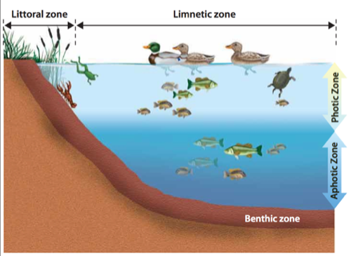
ProductivitySalt marsh:Mangrove swamIntertidal zone:
Ocean zones:
Delete this content
Biodiversity next:Look:Here's what we learned so far:
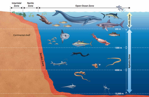
http://physics.hpa.edu/groups/apenvironmentalscience/weblog/542a8/Biodiversity_and_Extinction_Ch_5_Mods_1417.html0 commentsadminMod 12 Terrestrial Biomes
Delete this content
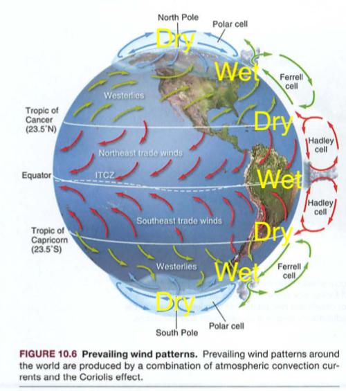
Now look at this map, and compare with your trusty globe:
Delete this content
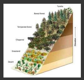
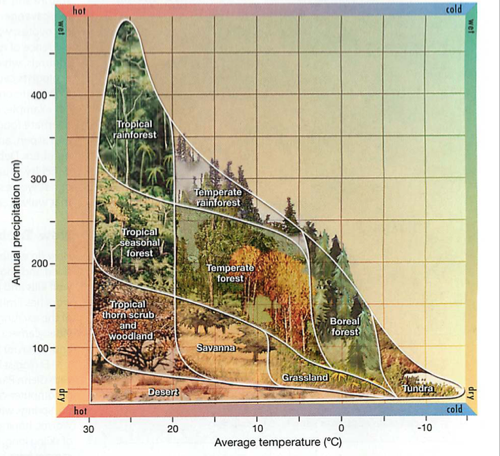
See the pattern?Pay close attention to cause and effect:There are about 9 Biomes, usually defined by (rain, fog, others) and . Big Island has 8 of the 9 biomes, or in the 12 biome model, we have 11/12, or 9 of 13, or 10 of 14 in another model. Many models...Traveling up a mountain is like crossing biomes. Check this out:
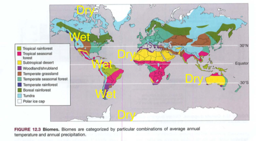
onshore moist air from the Pacific ocean hits the mountains near Seattle=rainy thereonshore moist air from the lower Atlantic ocean hits the amazon basin=rainy theredry air moving down from the Mediterranean moves over the Sahara Desert=dry there
precipitationtemperaturehttps://www.hawaiimagazine.com/content/hawaii-has-10-worlds-14-climate-zones-explorers-guide-each-themDelete this content
Imagine driving from Hamakua or Hilo up to the summit of Mauna Kea: tropical rain forest to temperate (mild) rain forest to boreal (north) forest to tundra. There is even a glacier up on Mauna Kea. Cool.This would be like starting in the upper right corner of the diagram and moving diagonally down and to the left.Now check out the planet again:
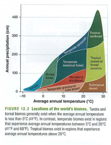
Delete this content
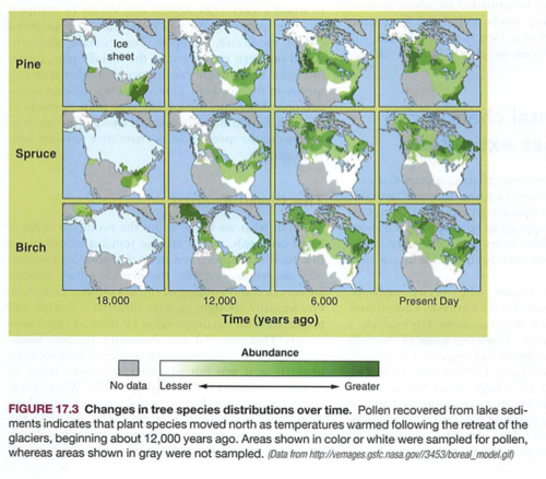
Notice the horizontal bands. If you've read "Guns Germs and Steel" you know that humans migrated horizontally, so their crops and livestock would thrive in similar biomes. See? Migrating north to south is tough.How is this changing?Now look at this:
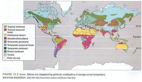
https://climate.nasa.gov/interactives/climate-time-machine
Delete this content
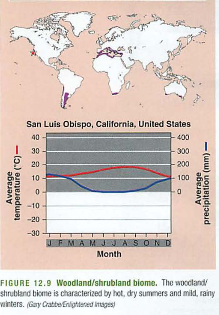
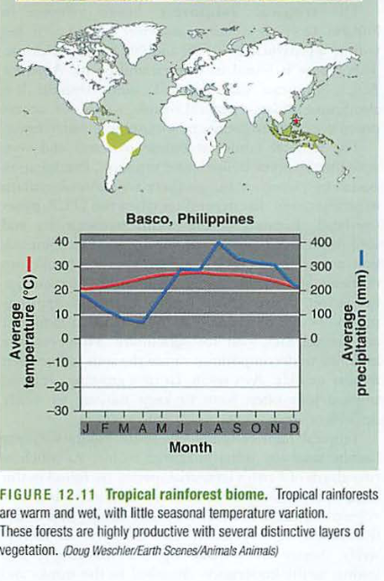
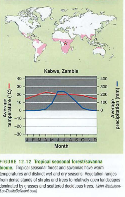
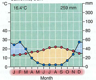
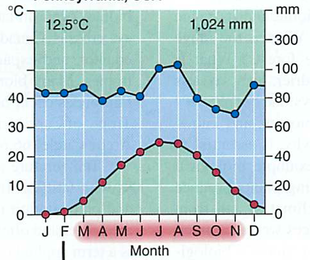
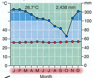
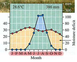
These diagrams are how climatologists describe biomes without a cool map. The blue line is the amount of rainfall, with units on the RIGHT side of the graph. The red line is the temperature, with units on the LEFT side of the graph. The shaded region in the months below (jfmamjjasond) is the growing season when temperatures are above freezing. When the precipitation line is above the temperature line, growth is limited by temperature (e.g. freezing). When the blue line is below the red line, growth is limited by precipitation (e.g. the desert).Start with the north: Tundra is what you'd see in Alaska. Permafrost is soon to be in the news. It is made of permanently frozen ground a few feet below the surface. Even roots cannot penetrate it, so some trees grow in a stunted fashion. It is also composed of frozen organic matter, which when it melts will decompose, releasing CO2 and CH4 (methane), which is 20x as powerful as CO2 as a greenhouse gas.

Tundra:
Delete this content
Note the cool temp, so growth is determined by temp, not rainfall. Lots of snow here, and little liquid water for plants, so yeah, mainly snow and glaciers.
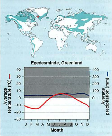
Contrast that with the boreal (north) forest:
Delete this content
Note the short growing season. Any plants that survive usually have an oily sap (pine trees, evergreens) that does not freeze. Also note the serious cold in the winter-animals have to adapt to these (fur, hibernation, etc.) are nicer, longer growing season, and rarely freeze. They are usually near the ocean, so they do not freeze (ocean is a huge heat sink). The often have lots of rain (think of Seattle). You may recall these are places where the surface parts of Ferrell and Polar cells converge, bringing in clouds and as these clouds rise into the atmosphere, they release their water as precipitation.

Temperate (mild) forests
Delete this content
Temperate (mild) seasonal forest actually has seasons:

Delete this content
Deciduous trees can live here, like maple and oak. It gets close to freezing, but no real dry season. is like much of southern California, or the Mediterranean. Wine can grow here. It is also known as the mediterranean (medi=middle, terra=earth) biome.

Woodland/shrubland
Delete this content
Note it never really freezes, but growth is determined by precipitation (blue line is below the red line). This is also known as "chaparral" or the "fynbos" or "nice forest" in Afrikaans (South Africa). Look up the main wine regions of the world, they will fit this biome. Also consider how many Italians could start vineyards in northern California... is a dry, grassy area, like Oklahoma, although it does get very cold there, so think more of Texas, or the Gobi desert. Again, growth is rain limited: (you may recall these are near Hadley/Ferrel cell subsidence, so dry air from space falls here). These areas tend to be far from large bodies of water, so they have more extreme temperatures than similar latitudes near water (e.g. Italy, France, California)
Temperate grassland/cold desert
Delete this content
is the rainiest of them all, and much of our island has this near the shore. Warm temperatures, and paradoxically poor soil nutrition (all of the nutrients are in the plants). On Mt. Waialeale on Kauai, the rainfall is 480 INCHES per year, 2.5 times as high as the high point on the chart below:
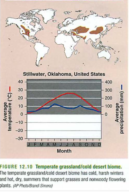
Tropical rainforest
Delete this content
Africa and Brazil hold the next biome: . Think of Madagascar (the film): not many large trees, room for animals to roam, lots of grass, happy lions, maybe a bossy penguin or two...Growth dependent on rainfall: (blue line below red one)
Savanna or tropical seasonal forest
Delete this content
Finally, the , like what you'd see in the Sahara desert (another film), or most of Australia, the Atacama in Chile, the Mojave desert in California, and some of Mexico. Note the Gobi desert is not on this list-too cold. Again, note these areas are where dry air subsides (falls) from the Hadley and Ferrell cells.
subtropical desert biome
Delete this content
Clues:

Biome Game:
Delete this content
Philadelphia, PennsylvaniaSan Diego, CaliforniaBelem, Brazil
Delete this content
Delete this content
Delete this content
Find these biomes below:
tropical rain forest
tropical savanna
desert
temperate grasslands
temperate deciduous forest
temperate rain forest
boreal forest
tundra
Delete this content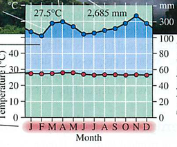
Delete this content
Delete this content
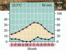
Delete this content
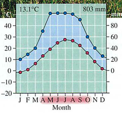
Delete this content
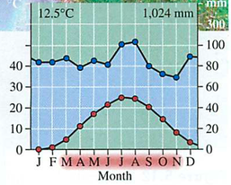
Delete this content
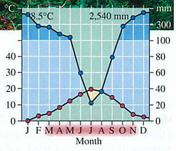
Delete this content
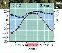
Delete this content

Find these biomes:
Tropical Savanna
Temperate Grassland
Chaparral
Desert
Tundra
Taiga
Temperate Deciduous Forest
Tropical Rain Forest
Delete this content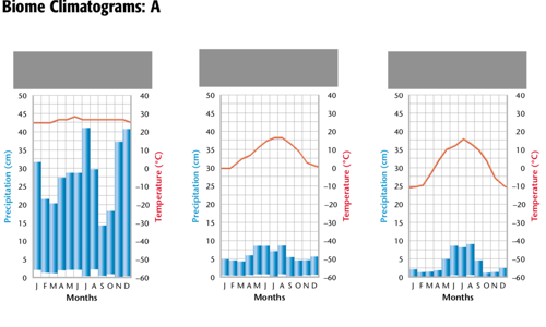
Delete this content
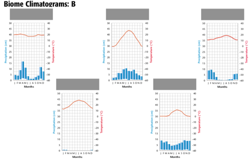
LAB: Gambling with biomes
Gambling with biomes
Below is a list of locations around the world. Roll the dice and using your vast knowledge of biomes and the high tech globes on your desk, determine the biome and type of life you might find there.In the next round reverse the process with the biome list below, determining the locations around the globe.
Locations:
ChileZambiaPhilippinesOklahomaSan Luis ObispoGermanySeattleGreenlandOntario CanadaTunisiaNorth PoleKamuelaBiomes:
tundraboreal foresttemperate rain foresttemperate seasonal forestwoodlandstemperate grasslandtropical rain forestsavannahdesertcold deserttaigatropical seasonal forestDelete this content
0 comments
September 27, 2021
by
Three ways heat energy moves:
: no medium needed, e.g. light
Radiation: contact
Conduction: matter in motion
ConvectionSummary:
Solar passes through the atmosphere
radiationRadiation hits the earth surface, to air
conductsHot air rises, () cooler air comes in to take its place
convectionTilt of the earth: Basis for seasons : tilt away=winter
equinox=equal night, solstice=extremes
Equator is hottest, so greatest convection there
Three cells based on convection, cause winds
Hadley, Ferrel, Polar
Ocean currents follow the winds, clockwise in N hemisphere
Cells converge at rainy spots, diverge at deserts
Why? Clouds lift at convection spots, cooling them = rain
Dry air dropping from space = warm, dry air (deserts)
Layers: spheres bottom to top
: at the surface, where all weather happens, conduction to air from surface, convection to other layers, albedo is how much energy it reflects (albus=white)
tropo: higher, drier air, cooler, air travel is here, also ozone layer (stops UV)
strato: middle
meso: hot, charged particles, also ionosphere, bounces radio waves
thermo: outer
exo; even further, deflects solar wind, protects surface (none on Mars)
magnetoAir stuff:
compress air and it heats
uncompress air (e.g. altitude) it cools
warmer air holds more water
cooler air holds less water
humidity measures how much water in how much air
relative humidity: compared to how much it can hold at that temp
absolute humidity: total amount of water
dew point: temp where water condenses
rising air condenses (rain) “adiabatic cooling” rain carries the heat away
falling air heats (deserts) “adiabatic heating” absorbs energy from the surroudings
rain shadows=dry areas after mountains
saturated 100% RH air is fog, then rain or snow
Cells:
ITCZ: at the equator, inter-tropical-convergence-zone
Hadley cell: equator to 30°N or 30°S
Ferrel cell: 30-60°
Polar cell: 60-90°
since earth is spinning, as air flows south, it also falls a bit west=tradewinds
if air flows north, it also flows a bit east=westerlies (weather describes wind from source direction)
this change of direction creates the coriolis effect
Hurricanes are low pressure systems, rising air creates a counter-clockwise flow (L on the weather maps)
High pressure systems create clockwise flow (H on the weather map)
Oceans:
winds carry surface water along, so N hemisphere has clockwise currents (cool water off CA coast)
a special current from Greenland melt flows to Hawaii, called the thermo (heat) haline (salt) current.
ENSO is a big deal: normally winds carry water off-shore of chile, bringing up food from the deep ocean (happy fisherpeeps).
El Niño reverses this, so sad fisherpeeps
La nada is no flow at all
0 commentsadminModules 9, 10, 11 circulationCirculation modules:Module 9: Heating of the earthModule 10: Air circulationModule 11: Ocean circulationModule 9 heating of the earth
Delete this content
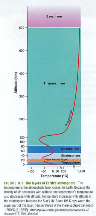
layers
Atmosphere slice:RH, AH
Air currents:radiation, convection, conduction
3 energy modes:Delete this content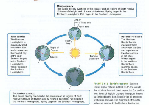
4 seasons (not just a hotel), equinox means "equal night”, solstices are the extremes (why sacred?)Earth spins counter clockwise when viewed from north pole (think: sun rises in the east)Latitudes are like a ladder, go horizontally (east to west), some short (near the poles), some long (equator)Longitudes are all long, go vertically (north to south), all the same lengthSeasons are determined by earth tilt, by distance to the sunnotAlthough, Australia (southern hemisphere) summer happens when we are closer to sun in our elliptical orbit, so more extreme summers (tilt + proximity)Albedo-think of Albus (white) Dumbledore, means reflectivity. Earth is about 30%, snow is 95%Delete this content
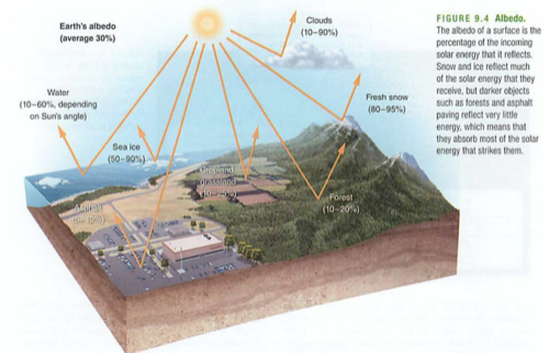
Module 10 Air currents and Water stuff the amount of water in the air at a certain temperature, relative to the maximum it could hold at that temperature (RH). Look this up here: Relative humidity:http://10.14.30.1You can blow on the room sensor and see this rise.: true amount of water in percent water in that parcel of air (AH)Absolute humidityDelete this content
You can look this up, it is called the "comfort curve" or psychrometric chart:
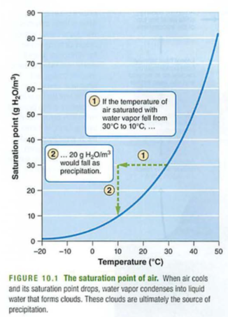
the max amount of water air can hold at that temp (rises with temperature, note how this compares with gases dissolved in liquids, like your dissolved oxygen (DO) lab. You may know this as fog.Saturation point:You may feel more comfortable with high temp and low humidity because your body can evaporate and cool more effectively. Conversely, humid, hot weather is ugly. Cold, humid air insulates poorly, so feels chilly, so running your air conditioner when it is humid and cool may actually make you feel warmer. Why?Delete this content

Delete this content
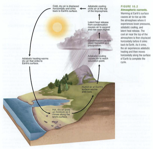
Questions:You see a circular flow in the counter-clockwise direction in the Northern Hemisphere on . Is this low or high pressure?windy.comWhy is the ocean less salty near the equator?As a parcel of air rises (like Waipio or the Himalayas), what happens to the absolute and relative humidity? What happens next?What level of the atmosphere has most of the weather and why? reverse of this: think of Puako or Kawaihae: as air descends, it is compressed and gets hotter.Adiabatic heating:when vapor condenses from gas to liquid, it releases energy. Opposite of evaporation or boiling, which both require energy.Latent (hidden) heat release: one of three means that energy moves from place to place: Convection:radiation (like light, can be reflected), conduction (contact), convection (movement of mass, usually air or water). between 30N and 30S, convergence at the equator (hot air rises there), descends after shedding heat to space and water as it rises (rain), descending dry air forms deserts at 30N and 30S. Winds from the north to south at the surface, opposite in the stratosphere.Hadley cells:Delete this content
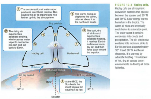
Delete this content
Check this out on windy.com:
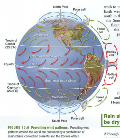
https://www.windy.com/?20.002,-155.533,5 intertropical convergence zone: the place near the equator where this convergence occurs, lower salinity in equatorial oceans (rains all the time, good AP question).ITCZ:Hadley Cells: Between the equator and 30N or 30S. between 30N and 60N, also on the southern hemisphere: deserts at the bottom, northward wind at the surface, opposite in space (stratosphere), which is why commercial flights usually have a headwind where they'd have a tailwind at the surface. Also why when trades are strong, mainland flights are faster/shorter.Ferrell cells: southward wind from 60N to 90N, creates dry desert at the north pole.Polar cells: spinning of earth makes air near the equator rotate faster around the axis than polar air. This difference creates hurricanes and ocean currents, therefore diagonal winds (see fig 10.6)Coriolis effect; think of the coast near Mahukona or Lapakahi, between Kawaihae and Hawi: very dry as all moisture has been wrung out of the air by ascending above mount Kohala. Think also of Eastern Washington, or the Desert in Chile, where the Andes dry out the air. Many more-find some!Rain shadow:
Delete this content
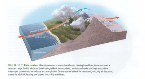
Check this out:
Delete this content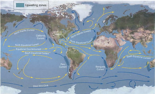
Verify on windy.com again:
https://www.windy.com/?20.002,-155.533,5Notice that the north pacific currents flow clockwise, south pacific counter clockwise. why?There are places with little forward current, so they become islands of debris, e.g. the so called "Pacific Gyre", which is about the size of Texas, and made up of floating trash.Gyres describe the circular flow, some refer to the islands of debris as gyres (not accurate), gyres are the circles, most equatorials move west (arrows match)Difference between flotsam and jetsam: one floats, the other is jettisoned from boatsThermohaline (thermo=heat, haline=saltwater) circulation:
Delete this content
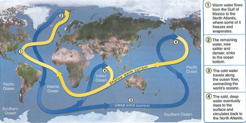
Note: top diagram has strong OFFSHORE wind, pulling up nutrients from below, note also that it is one big box from Peru to Indonesia, with a strong warm, dry subsidence around the coast of Peru (good for beach folks), known as La Niña, or the little girl,
Delete this content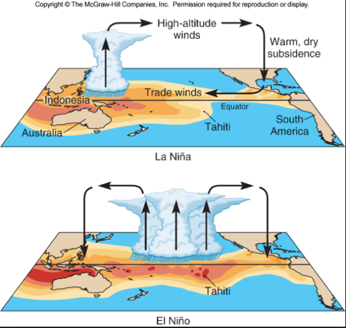
Note: lower diagram (El Niño) has main convection moving to the middle of the ocean basin, weakening the offshore wind around Peru, so sad fisher-folk. El Niño was often associated with Christmas, so the "little boy" reference.
Though ENSO is a single climate phenomenon, it has three states, or phases, it can be in. The two opposite phases, “El Niño” and “La Niña,” require certain changes in both the ocean the atmosphere because ENSO is a coupled climate phenomenon. “Neutral” is in the middle of the continuum, also known as “La Nada” or “the nothing”.
andEl Niño: A warming of the ocean surface, or above-average sea surface temperatures, in the central and eastern tropical Pacific Ocean. Over Indonesia, rainfall tends to become reduced while rainfall increases over the tropical Pacific Ocean. The low-level surface winds, which normally blow from east to west along the equator (“easterly winds”), instead weaken or, in some cases, start blowing the other direction (from west to east or “westerly winds”). This makes for sad fisher-people off the coast of Peru. Named for "the boy" or the Christmas child since it was first seen around December (winter solstice again).La Niña: A cooling of the ocean surface, or below-average sea surface temperatures, in the central and eastern tropical Pacific Ocean. Over Indonesia, rainfall tends to increase while rainfall decreases over the central tropical Pacific Ocean. The normal easterly winds along the equator become even stronger. Happy fisher-people off the coast of Peru due to nutrient upwelling from the Peruvian trench. Named after "the girl", just the opposite of "the boy".Neutral: Neither El Niño or La Niña. Often tropical Pacific sea surface temperatures are generally close to average. However, there are some instances when the ocean can look like it is in an El Niño or La Niña state, but the atmosphere is not playing along (or vice versa).Delete this content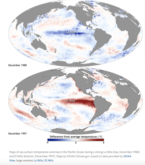
Figure 11.3 below——
Top: La Nada or La Niña: happy fisher-people off the coast of Peru (nutrient upwelling)
Delete this content-all life (also primary producer) gets energy from sun or heat directly, also known as autotrophexample: grass: CO2 + water + energy (heat or light) -> sugars (CHO)Reverse process is : Sugars + O2 -> energy + CO2 + water
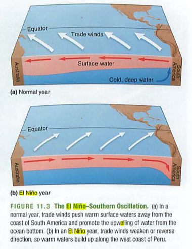
Bottom: El Niño: sad fisher-people off the coast of Peru
0 commentsadminChapter 3: modules 6-8 energy and matter cyclesModule 6: Movement of energyBiosphereProducerPhotosynthesisrespirationDelete this content(e.g. bacteria) don't use O2, less efficient, older primitive source of energy (pre-oxygen) (heterotroph) consumes other primary autotrophsTrophe = "nourishment"Trophic levels = food levels, see also food web gross primary productivity= Total amount of solar energy into the system: like gross income in a businesse.g. all of the money coming into your business net primary productivity = GPP minus respiration (think of Maui onions): gross income-expenses=net income-total mass of all living things in an ecosystem-odd fact: rain forest soil is the lowest in nutrients and biomass-why?-total plant biomass (e.g. forest)Efficiency is low (around 10%) 10x reduction in energy for each level (why?)-vegetarians vs. meat eatersSo, carnivores (us, wolves) are eating harvesting devices (cows) for autotrophs (grasses):
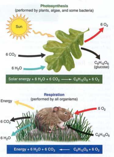
Anaerobic respirationConsumerPrimary consumers eat plants (e.g. herbivores)Secondary consumers eat them (carnivores)Tertiary consumers eat other carnivores (algae->zooplankton->fish->eagles)Scavenger-eats dead stuffDetritovore-eats dead stuff that is decayingDecomposers-break down into basic elementsGPPNPPBiomassStanding cropTrophic pyramid:Delete this content
Not very efficient, unless you can't digest grass, or it takes too much energy to walk around all day. This IS, however a good argument for global sustainable survival, as the sun will not go away soon, and as long as we have arable (farmable) land to grow plants, we could survive with a global population of 8-10 billion.But we'd need access to fresh water...
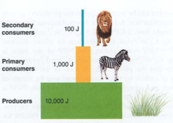
Delete this content
Biogeochemical cycles: bio=life geo = minerals chemical = chemical cycle = something that rotatesHeat provides energy for , Plants secrete water as , is collection of water vapor to drops, is the falling of these drops as rain, snow, hail etc. amount of water moving through an ecosystem, usually plants.Farmers need to know EtO to know how much water to supply to their crops.Eto depends on sunlight, humidity, wind and temperature (think of how these impact transpiration)
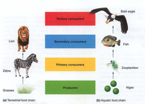
Module 7: Movement of Matter
Hydrologic (water) cycle: evaporationtranspirationCondensationPrecipitationETO evapotranspiration:Delete this content
-just like it soundsYou will need to know about "transit time" which is the time it takes rain to reach a water body after hitting the groundWhy is this crucial?(you will see this mentioned in the Poisoned Waters video this weekend) photosynthesis, respiration, exchange, sedimentation, burial, extraction, combustionair<->water<->land-CO2 to sugar (air to plant structures or fruits-e.g. corn)-sugar to CO2-HCO3 (carbonic acid) e.g. seawater changing pH, remember?-CaCO3 (seashells, limestone) most efficient long term carbon sink (solids are dense)burial-just like it sounds, oil, coal, nat gasextraction-mining fossil fuelscombustion-burning fossil fuels with oxygen to release CO2
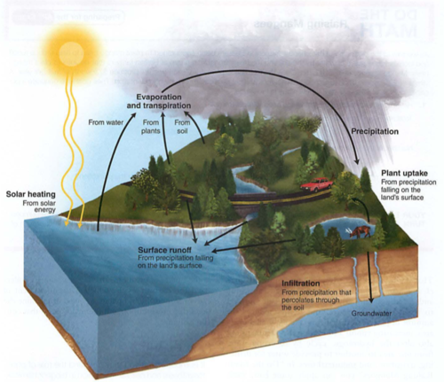
Runoff
Carbon cycle:photosynthesisrespirationacidification or exchangesedimentationDelete this content
6 macronutrients needed by plants: N,P,K, Ca, Mg, S (sulfur becomes part of Methionine, an amino acid)NPK from fertilizersN is a limiting nutrientN fixation is when you can't get Nitrogen off your mindIt also means bringing N2 gas from the atmosphere into the biome, biotically or abiotically (without life): lightning or burning fossil fuels (high temps) direct to nitrate (NO3) (that interesting smell after rainstorms): nitrogen fixing bacteria: N2 ->NO2 ->NO3 ->NH3 ->NH4 ion (used by producers, it is aqueous): petrochemicals to form fertilizers (NH3, anhydrous ammonia, ammonium nitrate NH4NO3, which is used in ANFO bombs): NH4+ ->NO2- ->NO3-nitrite kills bacteria (used in preserving meats), but nitrate is a good plant fertilizer (ANFO bombs): producing amino acids and then proteins (chains of AA) mineralization or ammonification (dead fish smell: NH4+ and amines) = "vital amines": NO3- goes to N2O to N2 gas (anaerobic bacteria, swamps): washing N out of soil
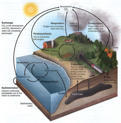
Nitrogen cycle:
quiz Define N, P, K and how each impacts plantsDefine evapotranspiration, condensation and precipitationWhich biogeochemical cycle only has a solid phase in the environment?What element replaces oxygen in chemosynthesis?
abioticbioticcommercial N fixationnitrificationassimilationDead stuff:Vitamins
denitrificationLeachingDelete this content
Mainly rocks, between land and waterONLY SOLIDS, NO LIQUID OR GAS PHASE: animals uptake PO4--- (see also phosphoric acid H3PO4), turn it into bones, teeth as CaPO4, then back to soil: phosphate sediments in ocean-> become rocks, erosion on land dissolves into watershed: phosphate detergents, fertilizers (Dead zones) PO4 -> lots of algae on surface (light) -> these die, fall to the bottom, and as they decompose, they take all O2 from the water (hypoxia)Arsenic in bananas---why we cannot use greywater for irrigation
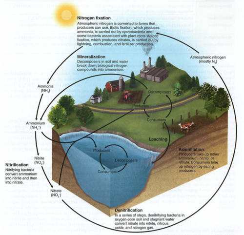
Phosphorus cycle:bioticabioticHumansAlgal bloom:Delete this content
dust (Kauai dependent on Gobi desert dust for K)rocks -> SO4, can become part of methionineSee also SO2 (vog, acid rain, pollution)
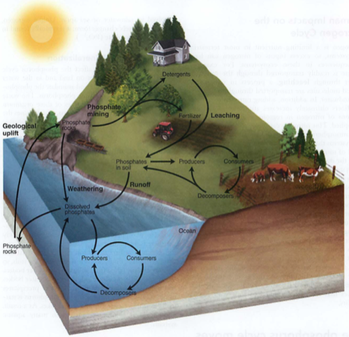
Ca, Mg and K:Sulfur cycle:Delete this content
Here's something interesting:Find Sulfur below:
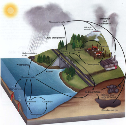
Delete this content
Ok, now find Oxygen. Hydrothermal vents use sulfur instead of oxygen for a thermal (heat) version of photosynthesis called Recall negative feedback (stable ships, relationships): greater the disturbance, the greater the restoring force (pendulums too) is how hard it is to move the pendulum (ecosystem) away from center is how fast the pendulum (ecosystem) returns to normalThis is strange stuff:Rare disturbances = competition, so only a few species dominateCommon disturbances = only fast reproducers survive, so low biodiversityIntermediate disturbances = highest biodiversity: drainage basin usually leading to a large body of water (Chesapeake watershed is huge):
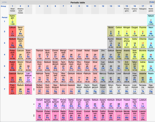
Module 8: Response to disturbancesResistance
ResilienceBiodiversity and disturbances:
Watershedhttps://www.cbf.org/about-the-bay/chesapeake-bay-watershed-geography-and-facts.html
Delete this content
How do you think this impacts the water quality, phosphates, nitrates and silt in the Chesapeake bay?Why are we not allowed above the fences behind Pu'u La'e La'e?On Oahu, the watershed is guarded by a barbed wire fence-why?How are the Himalayas acting as a watershed?:On campus try these:Systems
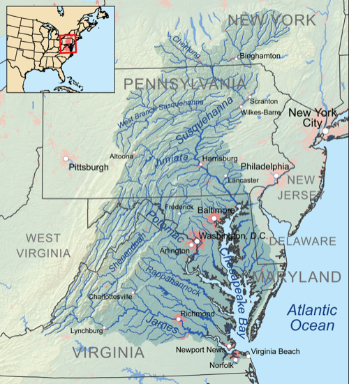
Poisoned waters:Videohttp://physics.hpa.edu/physics/apenvsci/videos/poisoned_waters/POISONED_WATERS.mp4
http://physics.hpa.edu/physics/apenvsci/videos/poisoned_waters/poisoned_waters.m4v
Weblog page:http://physics.hpa.edu/groups/apenvironmentalscience/weblog/973c4/Poisoned_Waters_videoPBS.html
http://physics.local/physics/apenvsci/videos/poisoned_waters/POISONED_WATERS.mp4
http://physics.local/physics/apenvsci/videos/poisoned_waters/poisoned_waters.m4vhttp://physics.local/groups/apenvironmentalscience/weblog/973c4/Poisoned_Waters_videoPBS.html
quiz why is the soil on Kauai so poor, and how does it get its Potassium?how does the size of the Cheseapeake watershed impact eutrophication in the Chesapeake bay?what is the difference between resistance and resilience in natural systems?why do rotting fish smell so bad?
Summary notes:systems are usually connected, exchange matter and/or energymain energy source is our sun, or past suns (e.g. uranium)feedback loops (again)spheres: litho=stone, bio=living, hydro=water, atmo=abovegeosphere: crust-mantle-core-inner core (spins, no way!)plates-who thought this up? need to understand convectionwhere are oldest parts of crust? trick questionsubduction zones, mid atlantic ridges (atlantis?)eq: deep near subduction zones, shallow in transform faultsmid atlantic ridge: how do we know this? submarineshimalayas-how? matterhorn-what?water cycle: evaporation and transpiration (eTO)precipitation-condensation is first (condensation nuclei, e.g. vog)aquifers-underground lakes, low turnover rate (pesticides) Oglallawater can be ground water: aquifer, water table, water lens or surface water
Migrated from Apple Server Wiki. Original page W1j374b3.ID: W1j374b3