
Lab 06: navigation: globes and calculating latitude
Migration
Globes 101:
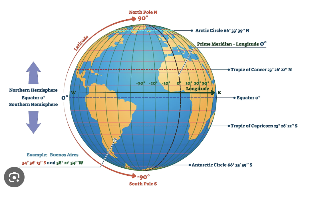
- start with the equator: named because it is an equal distance from each pole
- notice there is a 0° mark on the equator
- track north to see the degrees marked-these are latitudes (think of rungs on a ladder)
- do the same going south
- notice the tropics of Cancer and Capricorn, these are named for the star constellations that are at these angles in
progressthe sky
To navigate to a place on the globe, we need both latitude and longitude:
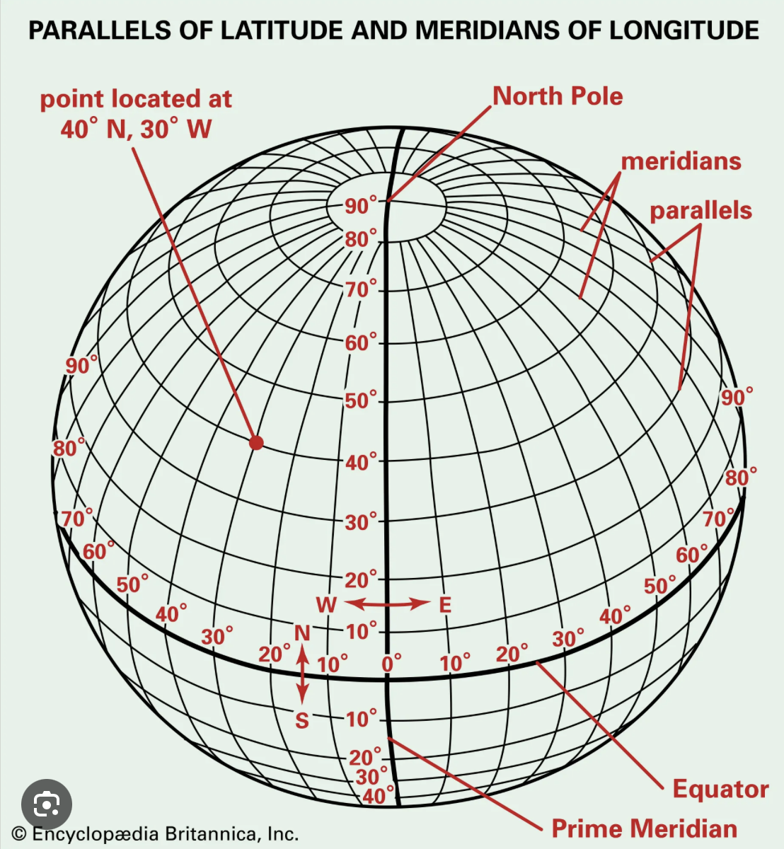
- Notice that 0° longitude is called the "prime meridian"
- This is no accident: the first telescope used to calibrate clocks to calculate longitudes while at sea was based outside London in a place called Greenwich (pronounced "gren-ich")
- This is why you might see times while traveling or calculating a phone or zoom call as GMT, this is Greenwich Mean Time, also known as UTC, or Coordinated Universal Time.
- In the diagram below, Washington DC is at 39° North Latitude or 39°N and 77° West Longitude (sometimes called 77°W
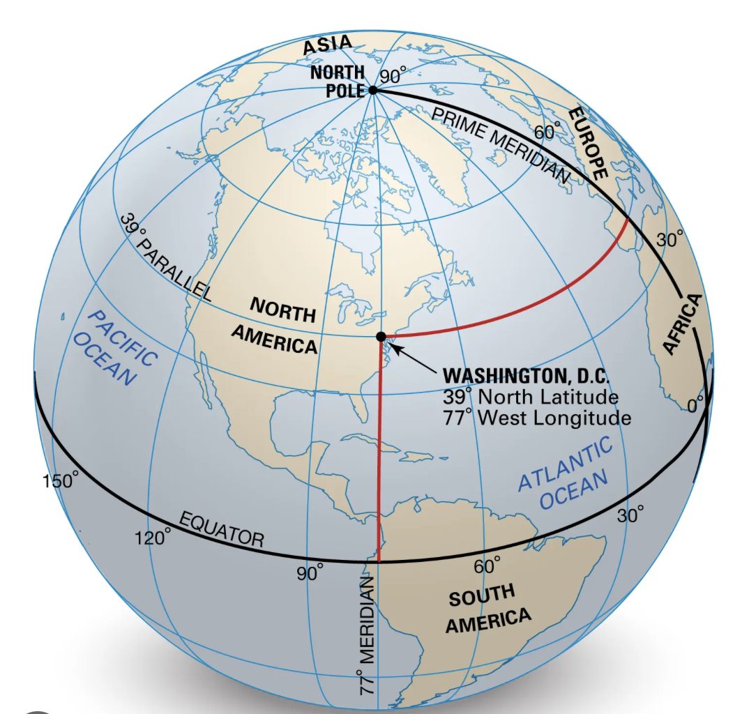
- Find the longitude and latitude of six places of your choice and quiz your classmates. Make sure to include several in both north and south hemispheres, east and west of the GMT line.
You can find people on the globe if you know both of these, even evil kidnappers like in the next lab...
Globe 102: Orbits and seasons
First you have to understand the seasons...
- map out the orbit of the earth around the sun on your big piece of paper (we know it is not a circle, ok for now), using a loop of dental floss
- label out the seasons on your paper, including the tilt angle of the earth at each transition, March 21, June 21, September 21, December 21, with June 21 at the top of your paper
- at the equinoxes ("equal night") determine the tilt of the earth everywhere on the planet
- what would the angle of a shadow look like in Waimea at noon on this date?
- compare with Alaska, Spain, Brazil, Germany and a few others that you pick
- Look these up here: https://www.sunearthtools.com/dp/tools/pos_sun.php?lang=pt
- repeat this at the solstices for these locations-what do you notice?
- if we lived on the tropic of cancer (north) or tropic of capricorn (south) what would the sun angle be on the solstices?
- what about on the equinoxes?
- why are they named this way? (look this up)
- what would be the lowest angle the noon sun should be in Waimea, and on what date?
- what would be the highest angle the sun should be at noon in Waimea, and on what date?
- what are the longest and shortest days where you are from?
- mark where we would be on your season map based on the date
- what degree should ours be between?
- measure the angle of the sun at around noon (noon is best, but close will be ok for now)
- using your angle, look up on a navigation almanac online what our latitude should be
- how close are you?
Questions:
- If you lived where the shadow of the sun was 22.5° at solar noon, on 9.21, where could you possibly be?
- What would your angle be on 12.21?
- What would your angle be on 6.21?
- What other date would have the same angle as #1?
- Calculate the noon solar angle for your home on 3.21
Migrated from Apple WikiServer Wiki. Original page C6S3f6.ID: C6S3f6