
Earth Science Modules 19-21 FR4e
Key points:
- All elements up to Iron on the periodic table came from the big bang
- Earth was formed from materials created by first generation stars going supernova
- The core of the earth is made up of a rotating solid core surrounded by a liquid core
- The inner core creates our magnetic field, which reverses periodically
- Layers: crust-mantle-outer core-inner core
- Uranium in the core produces heat that travels to the surface by convection
- Tectonic plates on the surface move on top of the sticky asthenosphere because of this convection
- Spreading zones are were these plates are created, subduction zones are where they dive under others
- Subduction zones create trenches in the ocean and andesitic volcanoes (sticky lava, pointy cones)
- Hot spots in the crust can create basaltic volcanic islands like the one we are on (runny lava, broad cones)
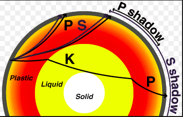
- Earthquakes include P (primary, compression) waves and S (secondary, shear) waves
- P waves are faster and go through solids and liquids, S waves only travel through solids
Big Bang:
- First, there was the big bang (see the cute video here: https://www.youtube.com/watch?v=xzAOhyOtfqc)
- The only thing at first was Hydrogen, which is just a proton and an electron, sometimes a neutron making isotopes of Hydrogen
- Stars formed from this hydrogen, and through fusion created all of the elements up until Iron (Fe)
- Look this up on your periodic table------https://ptable.com/#Properties
- Eventually, these stars expanded and then collapsed...Smaller stars became neutron stars or various versions of these
- Huge ones (15x our sun size) exploded and created all of the elements after Fe (check the periodic table again)so,
- Any element in you below Fe on the table came from an exploding star cool...
Exoplanets:
- NASA and other folks are really interested in two things now: exoplanets (planets outside our solar system) and asteroids https://www.cnn.com/2020/10/23/world/asteroid-bennu-sample-update-scn-trnd/index.html
- Why?
- Well, if we know what asteroids are made of, we have a clue about what materials (e.g. water) that were around when the solar system formed.
- This is why capturing materials from Bennu last week was such a big deal...
- From this info, we can look for those elements in other solar systems, and look for life there.
- Back to our earth...
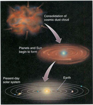
Our Solar System
- This is how our solar system formed.
- Our earth was molten for a long time, then cooled to become solid-mostly.
- Since it is also made up of Uranium and other things that combine to create heat, our planet is still really hot deep down.
- A minister named Ussher (https://en.wikipedia.org/wiki/Ussher_chronology) worked backwards from the molten state to solid state of the earth to guess that the earth was created one Sunday afternoon in 4004 BC.
- We was not stupid, he just did not know about Uranium, and our molten core...
- Here's what we know the earth to look like (check this out on your globes too):
- Layers: (onion boy)
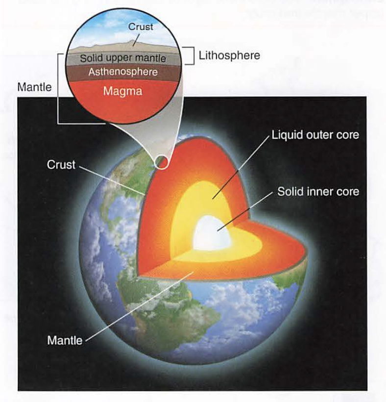
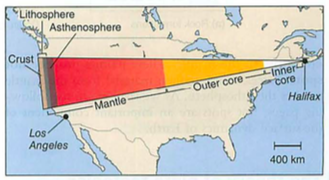
- The core is actually two bits: solid inner iron and nickel, liquid outside that bit.
- It spins, giving us a weak magnetic field which switches direction every few thousand years.
- Remember this, it comes up later...
- How do we know this?
- Nuclear bomb testing and our global seismic sensor network.
- How?
- Two key clues about the earth came from military conflict: one from WWII and another from the cold war, when everyone was building bigger and bigger bombs.
First the cold war part:
- We set up seismic sensors called seismographs all over the world to spy on Russian and Chinese nuclear ("A-Bomb", fission) and thermonuclear ("H-Bomb", Fusion) bomb testing to see how powerful they were.
- You next need to know that there are two main types of earthquake wave:
- P or "primary" waves which are compression waves. and S waves "secondary waves" that are transverse, like shaking a slinky.
- P waves are faster, and go through solids or liquids, but at slightly different velocities.
- S waves are slower, and can only travel through solids.
- So, here's what they saw:
- This data was found by spying on atomic bomb tests in the 1950s, not because we wanted to know about the guts of our planet...
- Submarines like to hide underwater, so planes and ships can't find them.
- So, during WWII, our side tried dragging little magnetic sensing torpedo thingys from behind their ships, hoping to detect submarines. (they later used airplanes too).Here's what they found:
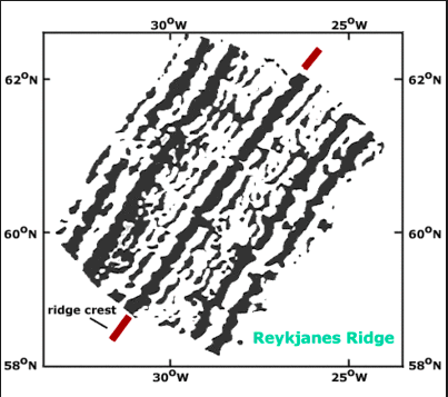
This might help:

Ok, let's break this down:
- Between England and the US, they found stripes of North then South weak magnetic fields.
- When they got to the middle of the Atlantic (about where Iceland is on the map above), the pattern reversed.
- Huh?
- That's what they said too...
- Remember the shifting magnetic field every few thousand years?
- As the magma came out of the earth in the molten state, it solidified in the magnetic field of that time, so the newest lava was along the center of the ocean (under Iceland too).
Ok, now shift quickly to a meteorologist named Alfred Wegener. (look this guy up)
("Meteorologist" is a fancy name for a person who studies the weather)
He cut out the continents on a map (like, with scissors) and noticed that South America and Africa fit nicely together.
Try this on your globe----Everyone in the geology community told him he was nuts.
Fossils from different places lined up:
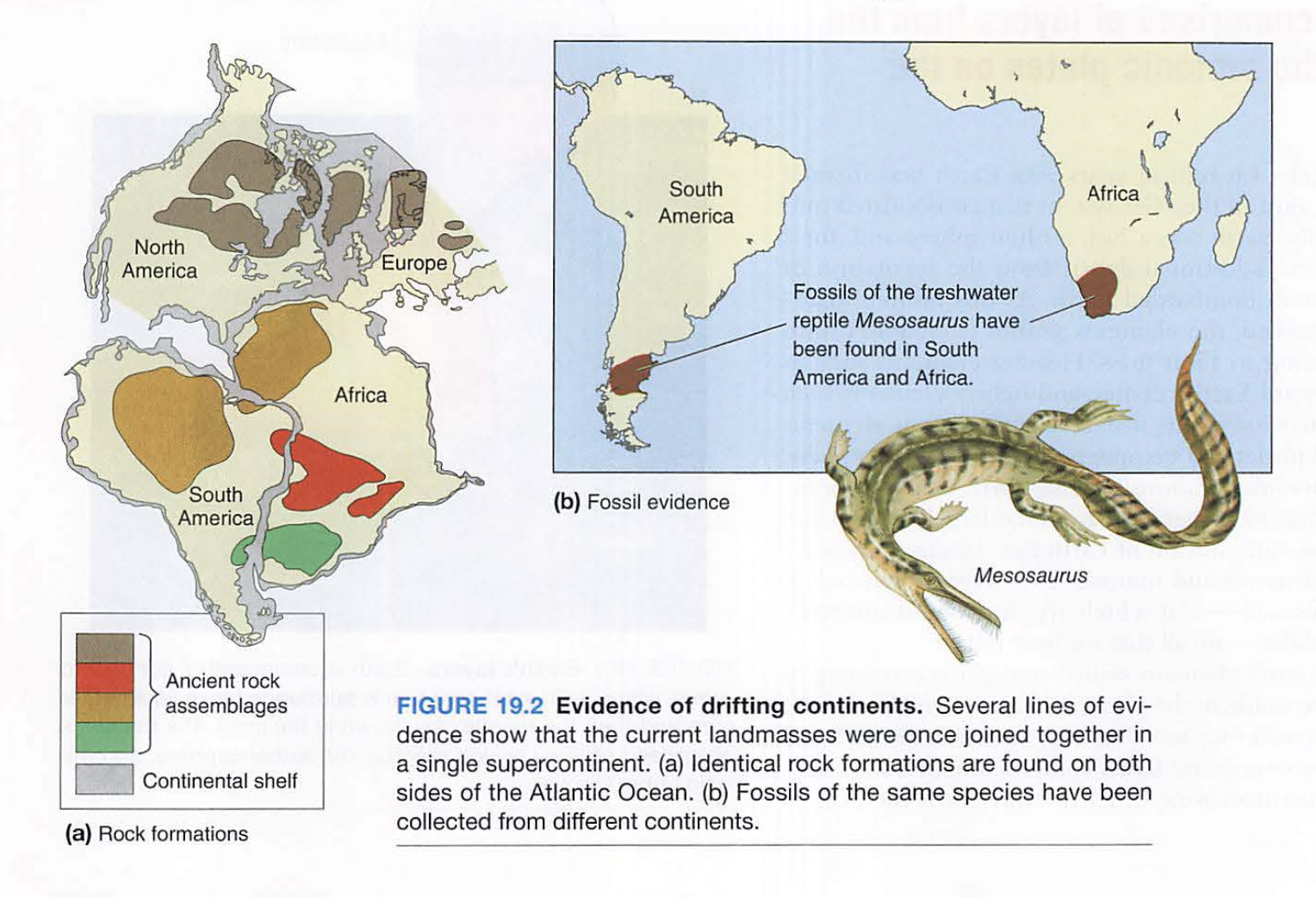
Then, these strange magnetic stripe thingys showed up from the ships dragging those magnetic torpedoes....and it proved he was RIGHT
He later froze to death in Greenland, but I digress...
Ok, now remember convection, conduction and radiation?
Remember how hot is was in the earth core?
That heat rises to the surface as magma (say like Dr. Evil), just like the Hadley, Ferrel and Polar cells do: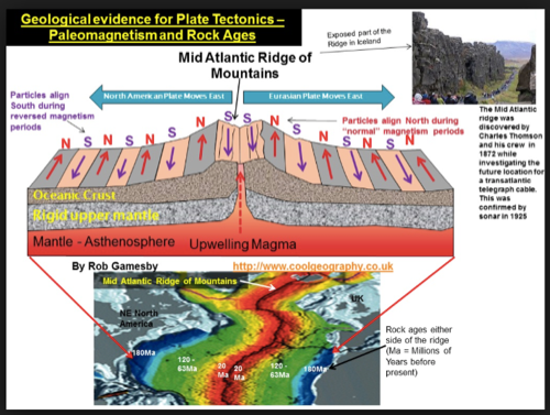
Remember the earth's magnetic field changing?
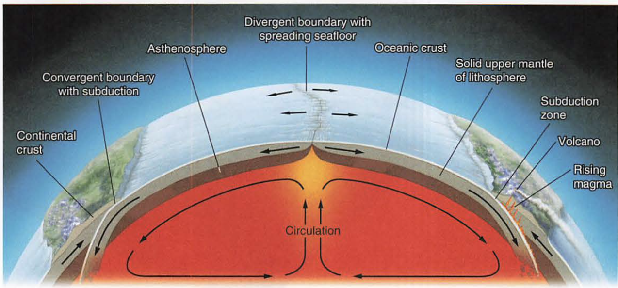
Check out this diagram: note the red (spreading) and the blue (subducting), esp. look at Chile---->
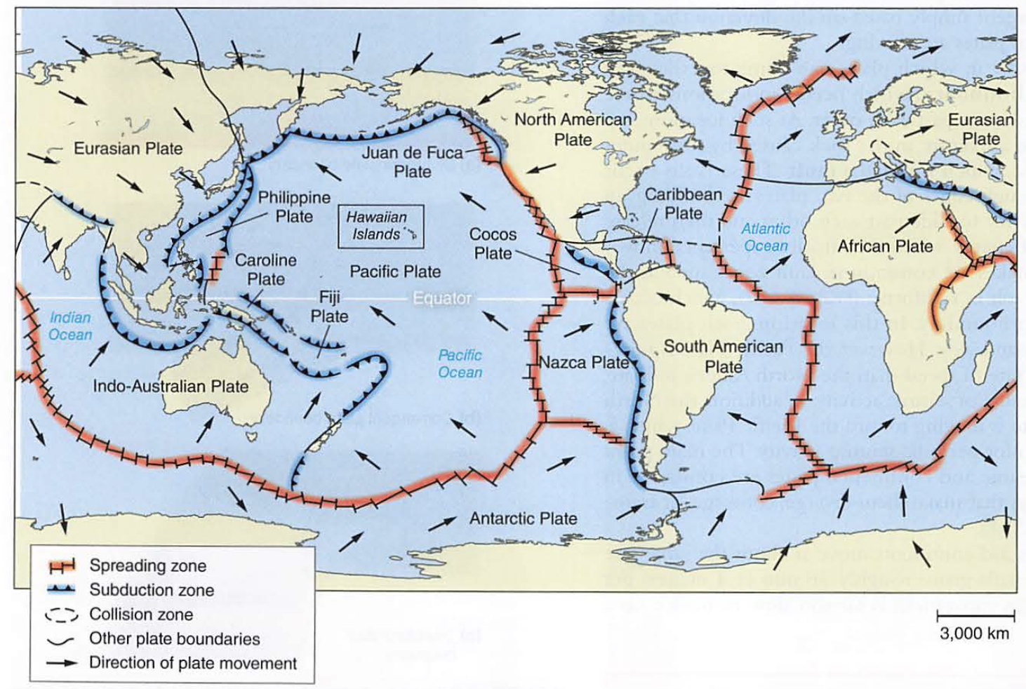
What about those mountains in Chile?
First, on your globes, trace out the red (subduction) zones and the blue (spreading) zones
This is the key to the two types of volcanoes:
Andesitic (pointy)
Basaltic (runny, look out your window)
Andesite-from pressure and heat as plates subduct (sticky, high silica content, e.g. Andes mountains)
Basalt-from ocean crust, lots of water, makes for weak, runny magma, formed as magma pushes through watery ocean plates
Subduction zones:
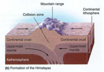
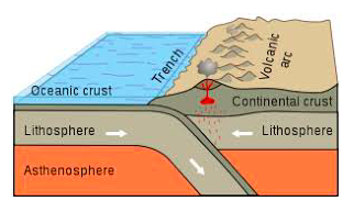
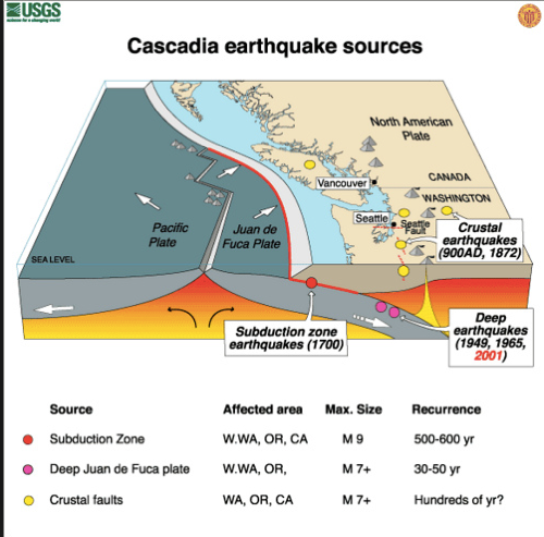
- Note the sticky stuff boiling up in red-this is why the Andesitic volcanoes are sticky, and always found near subduction zones (Andes, Cascades, Japan, Italy, etc.)
- Note also the trench where the subduction zone goes down: this is the origin of the Chilean/Peruvian trench we covered in the El Nino notes, as well as the deepest part of the ocean: the Marianas Trench, which is 7 MILES deep.
Whoa!
Now put it all together: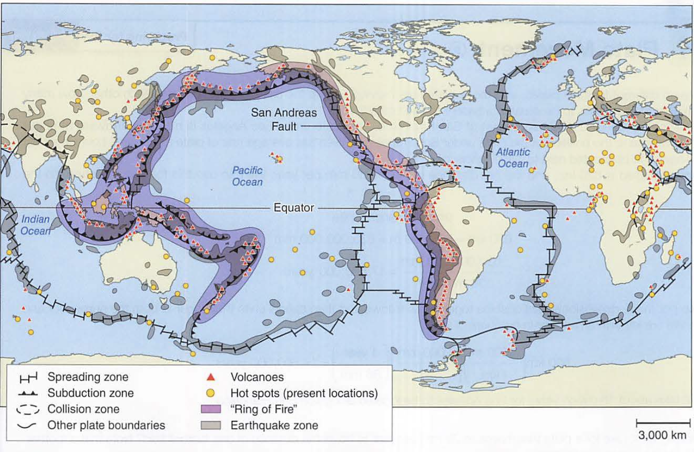
- Look at the red triangles (volcanoes)
- Which ones are andesitic and which are basaltic?
- (clue: hotspots)
Let's review the geological players:
- Magma-(Dr. Evil voice here: https://www.youtube.com/watch?v=yVo1S52xdpI)
- Asthenosphere-"sticky rock" (from Greek ἀσθενής asthenḗs 'weak' + "sphere")
- Lithosphere-floating rock (litho = stone) (Ancient Greek: λίθος [lithos] for "rocky", and σφαίρα [sphaira] for "sphere")
- Continents-even more floaty, made of lighter rock (granite) that formed from the interaction of magma with oceans
Plates and continents:
Check this out:- Plates are large, float on the Asthenosphere (less dense, so they float)
- Continents are like rafts on the Asthenosphere, more buoyant than the plates
- The plates can slide under each other (subduction zones), crash into each other (Himalayas), next to each other (transform faults), and are formed at spreading zones (divergent boundaries)
 |
| Click for a full-size image |
Two things to take-away about subduction zones:
1. subduction zones create ANDESITIC (pointy) volcanoes, which are high in silica, and sticky like thick pancake batter.
2. subduction zones create lots of deep-focus earthquakes.
2. subduction zones create lots of deep-focus earthquakes.
We are lucky enough to live on an island with several active or dormant volcanoes.
We live on top of a "hot-spot":
Hot spots:
- Usually in the middle of an oceanic plate, but can also be mid-continent (e.g. Yellowstone supervolcano caldera)
- Hot spots-basalt-low silica content which melts easier (e.g. look out the window)
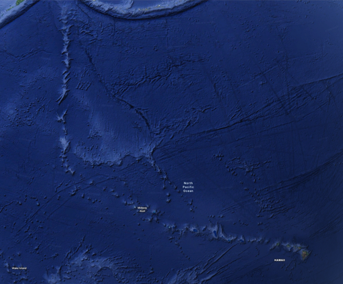
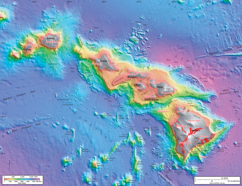
- Look at the Hawaii island chain on google earth (underwater version)
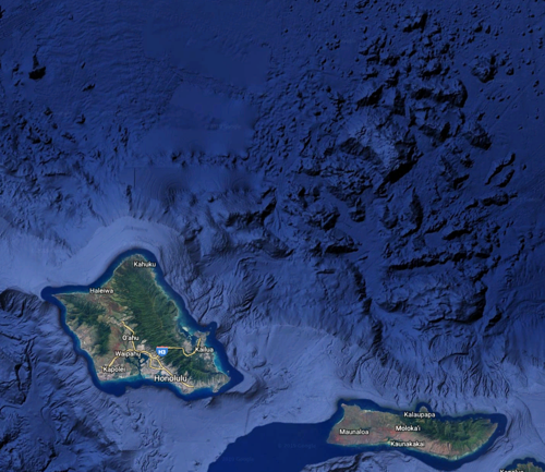
- While you are at it, look for the Nuuanu landslide that created a 4000' tsunami (!) 1.5 my ago
- You can also look at the Mauna Loa simulated tsunami on youtube...
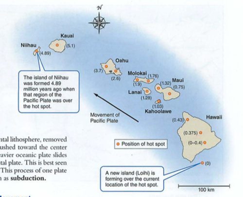
Note the tracking of the pacific plate:
This is what happens to a shield volcano when it "calves" one side, in this case, the northeast side, in the Nuuanulandslide, one of the largest landslides on earth, causing a tsunami that deposited coral on the top of Mt. Kaala, 4055 ft. high...
More about earthquakes:
Three types of fault boundaries:
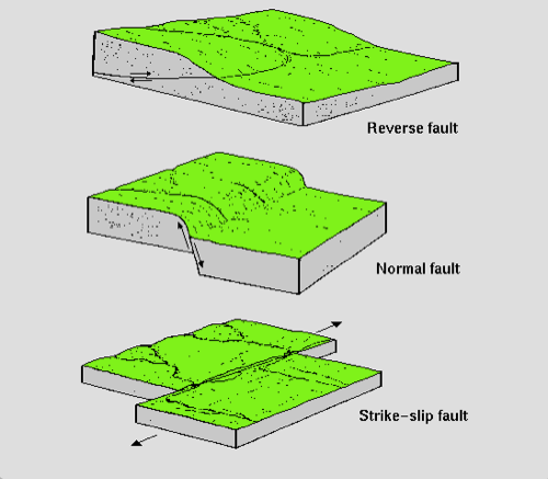 then there's the famous "not-my" fault...
These map to three types of plate boundaries:
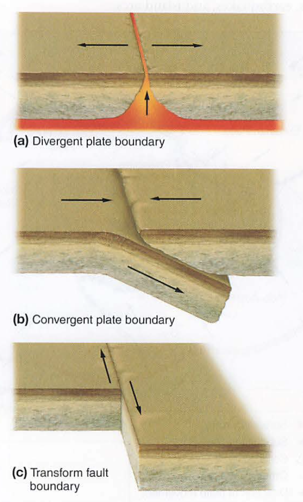
Earthquakes occur where there is movement between plates or sections along fault lines.
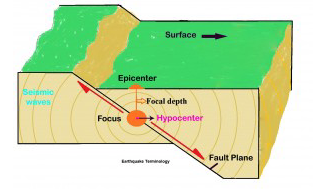
The epicenter is the place ON THE SURFACE above the hypocenter (true origin) or earthquake FOCUS.
Deeper hypocentric quakes often feel "longer", while shallow hypocentric quakes feel "sharp".
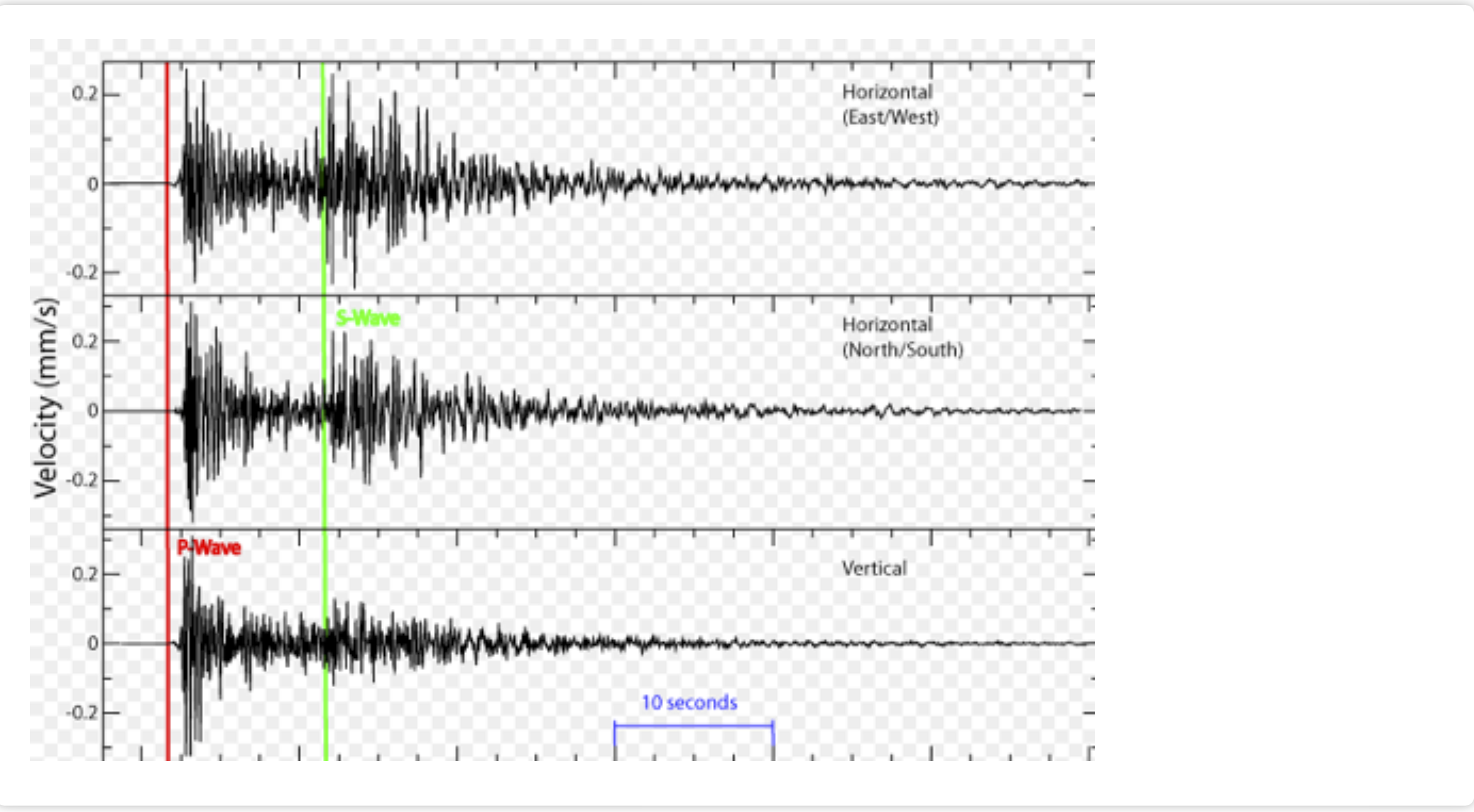
Since one wave (P wave) travels faster than the S wave, the farther away you are from the hypocenter, the greater the delay between the two:
How do we detect these?
Seismographs:
- P waves travel by compression (comPression).
- These are longitudinal waves, like sound.
- They can travel through liquid or solid.
- S waves travel by shear (Shear).
- These are transverse waves, like a slinky.
- They can only travel through solids.
- Remember this?
Ok, back to earthquakes.
- Suppose you have a house on posts (called "post and pier" construction).
- An earthquake happens some distance away.
- First, your house moves back and forth (P wave, much faster at 8 km/sec).
- After a time, your house bounces up and down from the S waves (slower at 3 km/second).
- If you are far away, these are separated by different arrival times.
- If you are near the epicenter, they hit at the same time...up, over, down=your house is demolished
- We use this difference to calculate distance from the epicenter (and hypocenter if you are interested) using delay times on the seismograph
Screenshot 2023-10-16 at 3.01.32 PM.png
- Look at the HPA Pacific Tsunami Warning Center (PTWC) seismograph here:http://www.fdsn.org/networks/detail/PT/
- Our Elab quake network here: https://shakenet.raspberryshake.org/
- Hawaii quakes here:https://volcanoes.usgs.gov/observatories/hvo/hvo_earthquakes.html
Click on some earthquakes and note the depth and the seismic image.
Migrated from Apple Server Wiki. Original page ID: q4a1y3v0